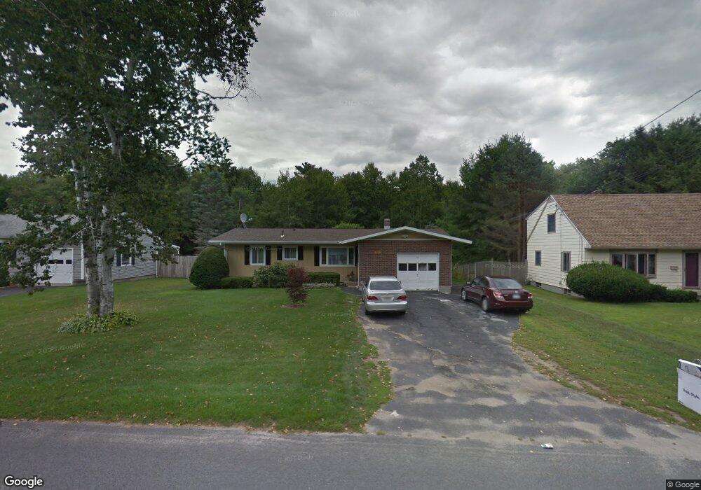
134 Maple Grove Dr Pittsfield, MA 01201
Estimated Value: $299,000 - $315,050
3
Beds
1
Bath
1,020
Sq Ft
$301/Sq Ft
Est. Value
About This Home
This home is located at 134 Maple Grove Dr, Pittsfield, MA 01201 and is currently estimated at $306,763, approximately $300 per square foot. 134 Maple Grove Dr is a home located in Berkshire County with nearby schools including Williams Elementary School, Theodore Herberg Middle School, and Pittsfield High School.
Ownership History
Date
Name
Owned For
Owner Type
Purchase Details
Closed on
Sep 15, 2003
Sold by
Bramley Genevieve S and Odonnell Sandra D
Bought by
Seygerman Semen and Seygerman Galina
Current Estimated Value
Home Financials for this Owner
Home Financials are based on the most recent Mortgage that was taken out on this home.
Original Mortgage
$108,800
Interest Rate
6.22%
Mortgage Type
Purchase Money Mortgage
Purchase Details
Closed on
Feb 19, 1988
Sold by
Baer Robert J
Bought by
Bramley Wesley A
Home Financials for this Owner
Home Financials are based on the most recent Mortgage that was taken out on this home.
Original Mortgage
$29,000
Interest Rate
10.45%
Mortgage Type
Purchase Money Mortgage
Create a Home Valuation Report for This Property
The Home Valuation Report is an in-depth analysis detailing your home's value as well as a comparison with similar homes in the area
Home Values in the Area
Average Home Value in this Area
Purchase History
| Date | Buyer | Sale Price | Title Company |
|---|---|---|---|
| Seygerman Semen | $136,000 | -- | |
| Bramley Wesley A | $93,000 | -- |
Source: Public Records
Mortgage History
| Date | Status | Borrower | Loan Amount |
|---|---|---|---|
| Open | Bramley Wesley A | $93,000 | |
| Closed | Bramley Wesley A | $108,800 | |
| Previous Owner | Bramley Wesley A | $29,000 |
Source: Public Records
Tax History
| Year | Tax Paid | Tax Assessment Tax Assessment Total Assessment is a certain percentage of the fair market value that is determined by local assessors to be the total taxable value of land and additions on the property. | Land | Improvement |
|---|---|---|---|---|
| 2025 | $5,091 | $283,800 | $80,000 | $203,800 |
| 2024 | $4,690 | $254,200 | $80,000 | $174,200 |
| 2023 | $4,369 | $238,500 | $80,000 | $158,500 |
| 2022 | $3,950 | $212,800 | $75,000 | $137,800 |
| 2021 | $3,698 | $192,100 | $75,000 | $117,100 |
| 2020 | $3,709 | $188,200 | $75,000 | $113,200 |
| 2019 | $3,354 | $172,700 | $70,000 | $102,700 |
| 2018 | $3,282 | $164,000 | $65,000 | $99,000 |
| 2017 | $3,145 | $160,200 | $65,000 | $95,200 |
| 2016 | $3,035 | $161,800 | $65,000 | $96,800 |
| 2015 | $2,922 | $161,800 | $65,000 | $96,800 |
Source: Public Records
Map
Nearby Homes
- 140 Maple Grove Dr
- 128 Maple Grove Dr
- 146 Maple Grove Dr
- 122 Maple Grove Dr
- 1 Maple Ln
- 127 Maple Grove Dr
- 152 Maple Grove Dr
- 116 Maple Grove Dr
- 2 Maple Ln
- 121 Maple Grove Dr
- 115 Maple Grove Dr
- 151 Maple Grove Dr
- 158 Maple Grove Dr
- 124 Birch Grove Dr
- 118 Birch Grove Dr
- 134 Birch Grove Dr
- 109 Maple Grove Dr
- 112 Birch Grove Dr
- 164 Maple Grove Dr
- 0 Maple Grove Dr
Your Personal Tour Guide
Ask me questions while you tour the home.