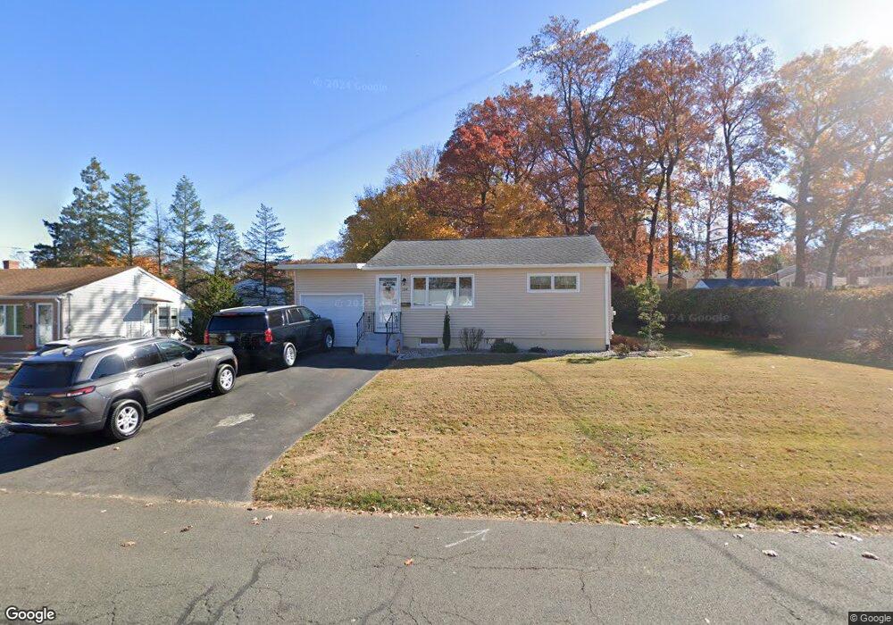
134 Merigold Dr New Britain, CT 06053
Estimated Value: $268,000 - $317,000
3
Beds
2
Baths
936
Sq Ft
$310/Sq Ft
Est. Value
About This Home
This home is located at 134 Merigold Dr, New Britain, CT 06053 and is currently estimated at $289,694, approximately $309 per square foot. 134 Merigold Dr is a home located in Hartford County with nearby schools including Holmes School, Pulaski Middle School, and St. Francis of Assisi Middle School.
Ownership History
Date
Name
Owned For
Owner Type
Purchase Details
Closed on
Nov 3, 1999
Sold by
Prieto Carlos and Prieto Michelle
Bought by
Davidson Mark A and Davidson Alecia M
Current Estimated Value
Purchase Details
Closed on
Nov 1, 1996
Sold by
Rosol Betty J
Bought by
Prieto Carlos and Prieto Michelle
Purchase Details
Closed on
Jul 3, 1995
Sold by
Yaglowski Marla and Yaglowski Gail
Bought by
Fischer Ida
Create a Home Valuation Report for This Property
The Home Valuation Report is an in-depth analysis detailing your home's value as well as a comparison with similar homes in the area
Home Values in the Area
Average Home Value in this Area
Purchase History
| Date | Buyer | Sale Price | Title Company |
|---|---|---|---|
| Davidson Mark A | $92,150 | -- | |
| Prieto Carlos | $85,000 | -- | |
| Fischer Ida | $69,000 | -- |
Source: Public Records
Mortgage History
| Date | Status | Borrower | Loan Amount |
|---|---|---|---|
| Open | Fischer Ida | $30,000 | |
| Closed | Fischer Ida | $97,300 | |
| Closed | Fischer Ida | $130,500 |
Source: Public Records
Tax History
| Year | Tax Paid | Tax Assessment Tax Assessment Total Assessment is a certain percentage of the fair market value that is determined by local assessors to be the total taxable value of land and additions on the property. | Land | Improvement |
|---|---|---|---|---|
| 2025 | $5,595 | $142,800 | $63,630 | $79,170 |
| 2024 | $5,653 | $142,800 | $63,630 | $79,170 |
| 2023 | $5,466 | $142,800 | $63,630 | $79,170 |
| 2022 | $4,484 | $90,580 | $29,330 | $61,250 |
| 2021 | $4,484 | $90,580 | $29,330 | $61,250 |
| 2020 | $4,535 | $89,810 | $29,330 | $60,480 |
| 2019 | $4,535 | $89,810 | $29,330 | $60,480 |
| 2018 | $4,535 | $89,810 | $29,330 | $60,480 |
| 2017 | $4,376 | $86,660 | $26,740 | $59,920 |
| 2016 | $4,376 | $86,660 | $26,740 | $59,920 |
| 2015 | $4,246 | $86,660 | $26,740 | $59,920 |
| 2014 | $4,246 | $86,660 | $26,740 | $59,920 |
Source: Public Records
Map
Nearby Homes
- 57 Merigold Dr
- 172 Batterson Dr
- 55 Alexander Rd
- 27 Janet Dr
- 678 Farmington Ave
- 160 Brittany Farms Rd Unit D
- 24 Pentlow Ave
- 2453 Corbin Ave
- 2415 Corbin Ave
- 432 Mcclintock St
- 153 Horseplain Rd
- 89 Hazelmere Rd
- 165 Bradford Walk Unit 165
- 45 Tunxis St
- 1634 Stanley St
- 43 Robin Rd
- 497 Commonwealth Ave
- 182 Francis St
- 31 Cheryl Dr
- 26 Magnolia St
Your Personal Tour Guide
Ask me questions while you tour the home.