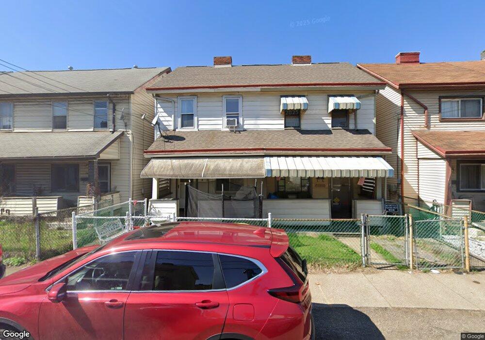
134 Orchard St Mc Kees Rocks, PA 15136
Stowe Township NeighborhoodEstimated Value: $55,000 - $67,000
2
Beds
1
Bath
1,060
Sq Ft
$57/Sq Ft
Est. Value
About This Home
This home is located at 134 Orchard St, Mc Kees Rocks, PA 15136 and is currently estimated at $60,223, approximately $56 per square foot. 134 Orchard St is a home located in Allegheny County with nearby schools including Sto-Rox Primary Center, Sto-Rox Upper Elementary School, and Sto-Rox Junior/Senior High School.
Ownership History
Date
Name
Owned For
Owner Type
Purchase Details
Closed on
Sep 17, 2024
Sold by
Goelz Thomas L
Bought by
Goelz Thomas L
Current Estimated Value
Purchase Details
Closed on
Sep 28, 2001
Sold by
Cercone Richard Anthony
Bought by
Goelz Thomas L
Purchase Details
Closed on
Mar 31, 2000
Sold by
Cercone Anthony J
Bought by
Cercone Richard Anthony
Purchase Details
Closed on
Aug 6, 1998
Sold by
Macik Michael
Bought by
Cercone Anthony J
Purchase Details
Closed on
Apr 28, 1995
Sold by
Coon Eugene L and Mcnamara John M
Bought by
Va
Purchase Details
Closed on
Mar 10, 1995
Sold by
Midfirst Bank State Svgs Bank
Bought by
Government National Mtg Assn
Purchase Details
Closed on
Mar 7, 1995
Sold by
Va
Bought by
Midfirst Bank State Svgs Bank
Purchase Details
Closed on
Jan 1, 1900
Create a Home Valuation Report for This Property
The Home Valuation Report is an in-depth analysis detailing your home's value as well as a comparison with similar homes in the area
Home Values in the Area
Average Home Value in this Area
Purchase History
| Date | Buyer | Sale Price | Title Company |
|---|---|---|---|
| Goelz Thomas L | -- | -- | |
| Goelz Thomas L | $19,000 | -- | |
| Cercone Richard Anthony | -- | -- | |
| Cercone Anthony J | $10,000 | -- | |
| Va | $2,614 | -- | |
| Government National Mtg Assn | -- | -- | |
| Midfirst Bank State Svgs Bank | -- | -- | |
| -- | -- | -- |
Source: Public Records
Tax History Compared to Growth
Tax History
| Year | Tax Paid | Tax Assessment Tax Assessment Total Assessment is a certain percentage of the fair market value that is determined by local assessors to be the total taxable value of land and additions on the property. | Land | Improvement |
|---|---|---|---|---|
| 2025 | $190 | $4,400 | $1,700 | $2,700 |
| 2024 | $190 | $4,400 | $1,700 | $2,700 |
| 2023 | $183 | $4,400 | $1,700 | $2,700 |
| 2022 | $177 | $4,400 | $1,700 | $2,700 |
| 2021 | $173 | $4,400 | $1,700 | $2,700 |
| 2020 | $173 | $4,400 | $1,700 | $2,700 |
| 2019 | $173 | $4,400 | $1,700 | $2,700 |
| 2018 | $21 | $4,400 | $1,700 | $2,700 |
| 2017 | $169 | $4,400 | $1,700 | $2,700 |
| 2016 | $21 | $4,400 | $1,700 | $2,700 |
| 2015 | $21 | $4,400 | $1,700 | $2,700 |
| 2014 | $169 | $4,400 | $1,700 | $2,700 |
Source: Public Records
Map
Nearby Homes
- 113 Ohio St
- 43 Orchard St
- 1213 Island Ave
- 19 Shaw Ave
- 22 Harlem Ave
- 124 Pleasant Ridge Rd
- 45 Harlem Ave
- 82 Harlem Ave
- 1421 Fleming Ave
- 270 Wheeler Ave
- 1490 Island Ave
- 234 Shiloh Ave
- 755 Frederick St
- 27 Highland Ave
- 188 Kendall Ave
- 125 Frazier Ave
- 837 Benwood Ave
- 711 Fruit Way
- 709 Fruit Way
- 155 Roosevelt Ave