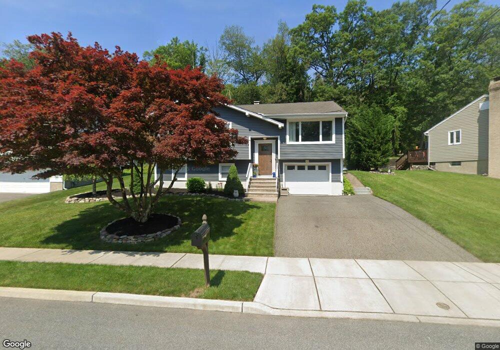
134 Red Twig Trail Bloomingdale, NJ 07403
Estimated Value: $549,875 - $652,000
--
Bed
--
Bath
1,780
Sq Ft
$337/Sq Ft
Est. Value
About This Home
This home is located at 134 Red Twig Trail, Bloomingdale, NJ 07403 and is currently estimated at $600,719, approximately $337 per square foot. 134 Red Twig Trail is a home located in Passaic County with nearby schools including Samuel R. Donald School, Martha B. Day School, and Walter T. Bergen Middle School.
Ownership History
Date
Name
Owned For
Owner Type
Purchase Details
Closed on
Sep 29, 2011
Sold by
Denorchia Rachel A and Bressette Eugene
Bought by
Bressette Eugene R
Current Estimated Value
Purchase Details
Closed on
Apr 27, 2007
Sold by
Bera Jerzy
Bought by
Bressette Eugene R and Bressette Rachel A
Home Financials for this Owner
Home Financials are based on the most recent Mortgage that was taken out on this home.
Original Mortgage
$43,000
Interest Rate
6.21%
Mortgage Type
New Conventional
Purchase Details
Closed on
Aug 31, 2005
Sold by
Vereschagin Valentin
Bought by
Bera Jerzy
Home Financials for this Owner
Home Financials are based on the most recent Mortgage that was taken out on this home.
Original Mortgage
$115,000
Interest Rate
5.79%
Create a Home Valuation Report for This Property
The Home Valuation Report is an in-depth analysis detailing your home's value as well as a comparison with similar homes in the area
Home Values in the Area
Average Home Value in this Area
Purchase History
| Date | Buyer | Sale Price | Title Company |
|---|---|---|---|
| Bressette Eugene R | $182,564 | -- | |
| Bressette Eugene R | $430,000 | -- | |
| Bera Jerzy | $455,000 | -- |
Source: Public Records
Mortgage History
| Date | Status | Borrower | Loan Amount |
|---|---|---|---|
| Previous Owner | Bressette Eugene R | $43,000 | |
| Previous Owner | Bressette Eugene R | $344,000 | |
| Previous Owner | Bera Jerzy | $115,000 |
Source: Public Records
Tax History Compared to Growth
Tax History
| Year | Tax Paid | Tax Assessment Tax Assessment Total Assessment is a certain percentage of the fair market value that is determined by local assessors to be the total taxable value of land and additions on the property. | Land | Improvement |
|---|---|---|---|---|
| 2025 | $12,477 | $272,000 | $135,200 | $136,800 |
| 2024 | $12,245 | $272,000 | $135,200 | $136,800 |
| 2022 | $12,226 | $272,000 | $135,200 | $136,800 |
| 2021 | $11,963 | $272,000 | $135,200 | $136,800 |
| 2020 | $11,865 | $272,000 | $135,200 | $136,800 |
| 2019 | $11,745 | $272,000 | $135,200 | $136,800 |
| 2018 | $11,682 | $272,000 | $135,200 | $136,800 |
| 2017 | $11,462 | $272,000 | $135,200 | $136,800 |
| 2016 | $11,023 | $265,300 | $135,200 | $130,100 |
| 2015 | $10,755 | $265,300 | $135,200 | $130,100 |
| 2014 | $10,360 | $265,300 | $135,200 | $130,100 |
Source: Public Records
Map
Nearby Homes
- 130 Red Twig Trail
- 138 Red Twig Trail
- 126 Red Twig Trail
- 142 Red Twig Trail
- 137 Red Twig Trail
- 141 Red Twig Trail
- 133 Red Twig Trail
- 122 Red Twig Trail
- 145 Red Twig Trail
- 129 Red Twig Trail
- 118 Red Twig Trail
- 149 Red Twig Trail
- 125 Red Twig Trail
- 114 Red Twig Trail
- 117 Red Twig Trail
- 247B Glenwild Ave
- 247 Glenwild Ave
- 110 Red Twig Trail
- 113 Red Twig Trail
- 239 Glenwild Ave