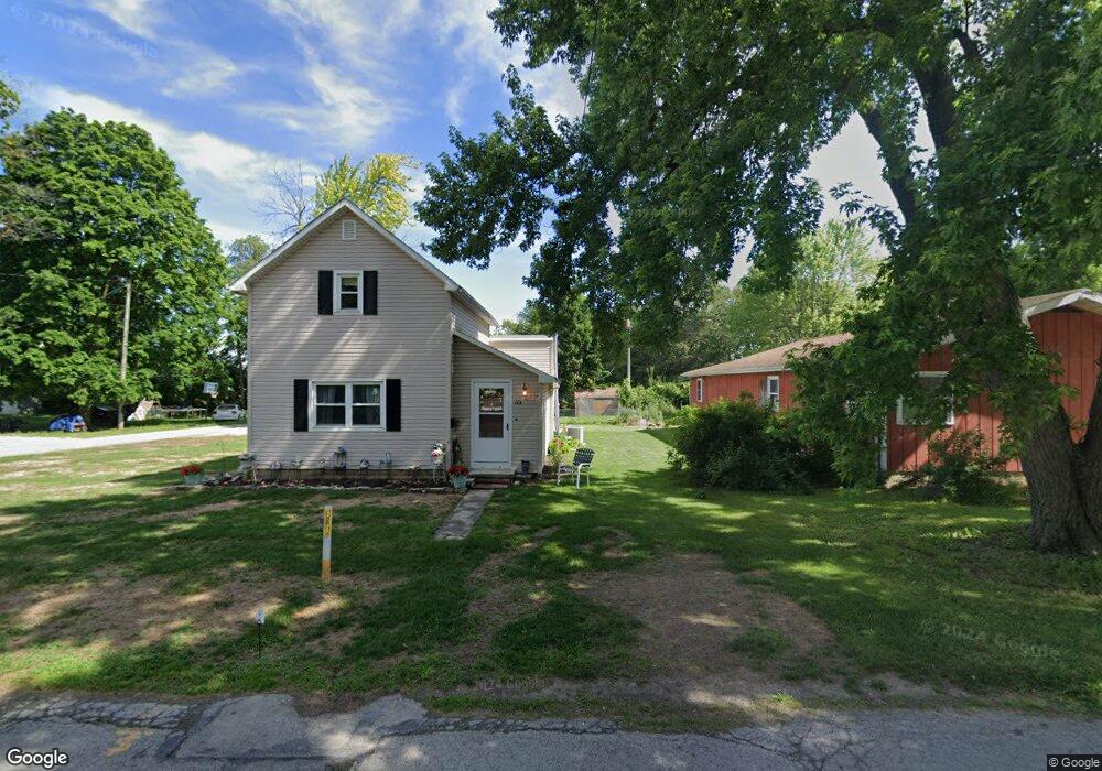
134 Rock St Fostoria, OH 44830
Estimated Value: $64,000 - $124,000
2
Beds
1
Bath
980
Sq Ft
$90/Sq Ft
Est. Value
About This Home
This home is located at 134 Rock St, Fostoria, OH 44830 and is currently estimated at $87,758, approximately $89 per square foot. 134 Rock St is a home located in Seneca County with nearby schools including Fostoria Intermediate Elementary School and Fostoria Junior/Senior High School.
Ownership History
Date
Name
Owned For
Owner Type
Purchase Details
Closed on
Feb 28, 2023
Sold by
Frankart William J
Bought by
Mep Property Management Llc
Current Estimated Value
Purchase Details
Closed on
Dec 28, 2015
Sold by
Frankart Nicholas J
Bought by
Frankart William J
Purchase Details
Closed on
Jun 3, 2014
Sold by
Frankart Arnold R and Ametrano Rosemarie H
Bought by
Frankart Nicholas J
Purchase Details
Closed on
Mar 22, 2004
Bought by
Frankart Arnold R
Purchase Details
Closed on
Mar 17, 2004
Sold by
Smith Chad C
Bought by
Bank One Na
Purchase Details
Closed on
Mar 11, 1996
Sold by
Smith Scott W
Bought by
Smith Chad C
Create a Home Valuation Report for This Property
The Home Valuation Report is an in-depth analysis detailing your home's value as well as a comparison with similar homes in the area
Home Values in the Area
Average Home Value in this Area
Purchase History
| Date | Buyer | Sale Price | Title Company |
|---|---|---|---|
| Mep Property Management Llc | $46,000 | Axxis Title Agency | |
| Frankart William J | -- | Attorney | |
| Frankart Nicholas J | $20,000 | None Available | |
| Frankart Arnold R | $26,500 | -- | |
| Bank One Na | $23,000 | -- | |
| Smith Chad C | $33,000 | -- |
Source: Public Records
Tax History Compared to Growth
Tax History
| Year | Tax Paid | Tax Assessment Tax Assessment Total Assessment is a certain percentage of the fair market value that is determined by local assessors to be the total taxable value of land and additions on the property. | Land | Improvement |
|---|---|---|---|---|
| 2024 | $798 | $15,500 | $1,760 | $13,740 |
| 2023 | $799 | $15,500 | $1,760 | $13,740 |
| 2022 | $638 | $11,030 | $1,520 | $9,510 |
| 2021 | $652 | $11,030 | $1,520 | $9,510 |
| 2020 | $655 | $11,022 | $1,516 | $9,506 |
| 2019 | $636 | $10,637 | $1,463 | $9,174 |
| 2018 | $742 | $10,637 | $1,463 | $9,174 |
| 2017 | $636 | $10,637 | $1,463 | $9,174 |
| 2016 | $732 | $11,690 | $1,617 | $10,073 |
| 2015 | $531 | $8,355 | $1,617 | $6,738 |
| 2014 | $540 | $8,355 | $1,617 | $6,738 |
| 2013 | $2,969 | $9,083 | $1,757 | $7,326 |
Source: Public Records
Map
Nearby Homes
- 1324 N Union St
- 375 Thomas St
- 900 N Countyline St
- 931 N Union St
- 892 N Countyline St
- 633 Maple St
- 827 Buckley St
- 723 N Union St
- 901 Central Ave
- 727 Eisenhower Dr
- 540 N Poplar St
- 520 N Union St
- 711 Circle Dr
- 220 E High St
- 481 Beverly Dr
- 203 N Union St
- 509 College Ave
- 412 E Center St
- 0 W South Route 12
- 348 W South St