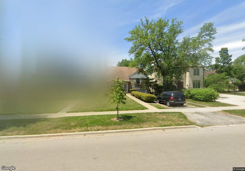
134 S Poplar Ave Elmhurst, IL 60126
Estimated Value: $531,000 - $678,356
--
Bed
--
Bath
1,485
Sq Ft
$397/Sq Ft
Est. Value
About This Home
This home is located at 134 S Poplar Ave, Elmhurst, IL 60126 and is currently estimated at $589,089, approximately $396 per square foot. 134 S Poplar Ave is a home located in DuPage County with nearby schools including Ravenswood Elementary School, Ruggles Elementary School, and Edison Elementary School.
Ownership History
Date
Name
Owned For
Owner Type
Purchase Details
Closed on
Jul 30, 2019
Sold by
Cummins Thomas W and Cummins Michele H
Bought by
Chasing 70 Llc
Current Estimated Value
Create a Home Valuation Report for This Property
The Home Valuation Report is an in-depth analysis detailing your home's value as well as a comparison with similar homes in the area
Home Values in the Area
Average Home Value in this Area
Purchase History
| Date | Buyer | Sale Price | Title Company |
|---|---|---|---|
| Chasing 70 Llc | $340,000 | First American Title |
Source: Public Records
Tax History Compared to Growth
Tax History
| Year | Tax Paid | Tax Assessment Tax Assessment Total Assessment is a certain percentage of the fair market value that is determined by local assessors to be the total taxable value of land and additions on the property. | Land | Improvement |
|---|---|---|---|---|
| 2024 | $7,578 | $133,737 | $119,938 | $13,799 |
| 2023 | $7,022 | $123,670 | $110,910 | $12,760 |
| 2022 | $6,841 | $118,820 | $106,610 | $12,210 |
| 2021 | $6,669 | $115,870 | $103,960 | $11,910 |
| 2020 | $6,409 | $113,330 | $101,680 | $11,650 |
| 2019 | $8,579 | $150,280 | $96,670 | $53,610 |
| 2018 | $8,755 | $152,320 | $91,520 | $60,800 |
| 2017 | $8,547 | $145,150 | $87,210 | $57,940 |
| 2016 | $8,347 | $136,740 | $82,160 | $54,580 |
| 2015 | $9,434 | $144,300 | $76,540 | $67,760 |
| 2014 | $9,774 | $137,830 | $60,940 | $76,890 |
| 2013 | $10,048 | $139,770 | $61,800 | $77,970 |
Source: Public Records
Map
Nearby Homes
- 128 S Linden Ave
- 153 S Kenmore Ave
- 130 S Elm Tree Ln
- 199 S Linden Ave
- 110 N Pine St
- 168 S Fairlane Ave
- 333 E Huntington Ln
- 396 E Park Ave
- 134 N Caroline Ave
- 145 S York St Unit 404
- 145 S York St Unit 322
- 435 E Park Ave
- 219 E Saint Charles Rd
- 454 E Park Ave
- 444 E Schiller St
- 240 N Willow Rd
- 105 S Cottage Hill Ave Unit 304
- 349 E Parkview Ave
- 286 N Indiana St
- 195 N Addison Ave Unit PH03
- 138 S Poplar Ave
- 142 S Poplar Ave
- 146 S Poplar Ave
- 303 E Marion St
- 150 S Poplar Ave
- 122 S Poplar Ave
- 139 S Lawndale Ave
- 295 E Marion St
- 145 S Lawndale Ave
- 151 S Lawndale Ave
- 141 S Poplar Ave
- 135 S Poplar Ave
- 147 S Poplar Ave
- 154 S Poplar Ave
- 285 E Marion St
- 131 S Poplar Ave
- 155 S Lawndale Ave
- 151 S Poplar Ave
- 114 S Poplar Ave
- 160 S Poplar Ave