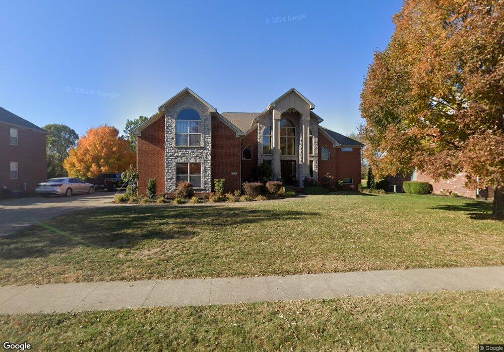
134 Saint Andrews Way Georgetown, KY 40324
Estimated Value: $434,000 - $544,000
5
Beds
4
Baths
2,388
Sq Ft
$208/Sq Ft
Est. Value
About This Home
This home is located at 134 Saint Andrews Way, Georgetown, KY 40324 and is currently estimated at $497,182, approximately $208 per square foot. 134 Saint Andrews Way is a home located in Scott County with nearby schools including Western Elementary School, Creekside Elementary School, and Royal Spring Middle School.
Ownership History
Date
Name
Owned For
Owner Type
Purchase Details
Closed on
Feb 1, 2007
Sold by
Haddix Construction Llc
Bought by
Haddix Paul and Haddix Nicole
Current Estimated Value
Purchase Details
Closed on
Oct 9, 2006
Sold by
Hudson Phillip and Hudson Cars
Bought by
Haddix Paul and Haddix Nicole
Home Financials for this Owner
Home Financials are based on the most recent Mortgage that was taken out on this home.
Original Mortgage
$77,250
Interest Rate
6.27%
Mortgage Type
Construction
Create a Home Valuation Report for This Property
The Home Valuation Report is an in-depth analysis detailing your home's value as well as a comparison with similar homes in the area
Home Values in the Area
Average Home Value in this Area
Purchase History
| Date | Buyer | Sale Price | Title Company |
|---|---|---|---|
| Haddix Paul | -- | None Available | |
| Haddix Paul | $53,500 | None Available | |
| Haddix Paul | $59,500 | None Available |
Source: Public Records
Mortgage History
| Date | Status | Borrower | Loan Amount |
|---|---|---|---|
| Previous Owner | Haddix Paul | $77,250 | |
| Previous Owner | Haddix Paul | $78,750 |
Source: Public Records
Tax History Compared to Growth
Tax History
| Year | Tax Paid | Tax Assessment Tax Assessment Total Assessment is a certain percentage of the fair market value that is determined by local assessors to be the total taxable value of land and additions on the property. | Land | Improvement |
|---|---|---|---|---|
| 2024 | $4,059 | $451,400 | $0 | $0 |
| 2023 | $3,941 | $434,700 | $75,000 | $359,700 |
| 2022 | $3,266 | $384,100 | $65,000 | $319,100 |
| 2021 | $3,438 | $365,000 | $65,000 | $300,000 |
| 2020 | $3,052 | $355,200 | $65,000 | $290,200 |
| 2019 | $3,100 | $355,200 | $0 | $0 |
| 2018 | $2,957 | $340,704 | $0 | $0 |
| 2017 | $2,971 | $340,704 | $0 | $0 |
| 2016 | $2,743 | $340,704 | $0 | $0 |
| 2015 | $2,670 | $333,700 | $0 | $0 |
| 2014 | $2,763 | $333,200 | $0 | $0 |
| 2011 | $207 | $333,200 | $0 | $0 |
Source: Public Records
Map
Nearby Homes
- 141 Shinnecock Hill Dr
- 194 Shinnecock Hill Dr
- 177 Swilcan Bridge Way
- 442 General John Payne Blvd
- 245 Sturbridge Dr
- 145 Inverness Dr
- 407 General John Payne Blvd
- 98 Delissa Dr
- 405 General John Payne Blvd
- 209 Christal Dr
- 134 The Masters
- 126 Autumn Leaf Path
- 109 Acorn Path
- 123 The Masters
- 119 Acorn Path
- 167 Delissa Dr
- 100 Canewood Blvd
- 106 Plymouth Ct
- 127 Anne Jennings
- 127 Lloyd Rd
- 132 Saint Andrews Way
- 136 Saint Andrews Way
- 130 Saint Andrews Way
- 138 Broadmoor Dr
- 140 Broadmoor Dr
- 131 Broadmoor Dr
- 136 Broadmoor Dr
- 129 Broadmoor Dr
- 132 Broadmoor Dr
- 134 Broadmoor Dr
- 135 Broadmoor Dr
- 135 Saint Andrews Way
- 138 Saint Andrews Way
- 133 Broadmoor Dr
- 137 Saint Andrews Way
- 133 Saint Andrews Way
- 128 Saint Andrews Way
- 131 Saint Andrews Way
- 129 Saint Andrews Way
- 139 Saint Andrews Way