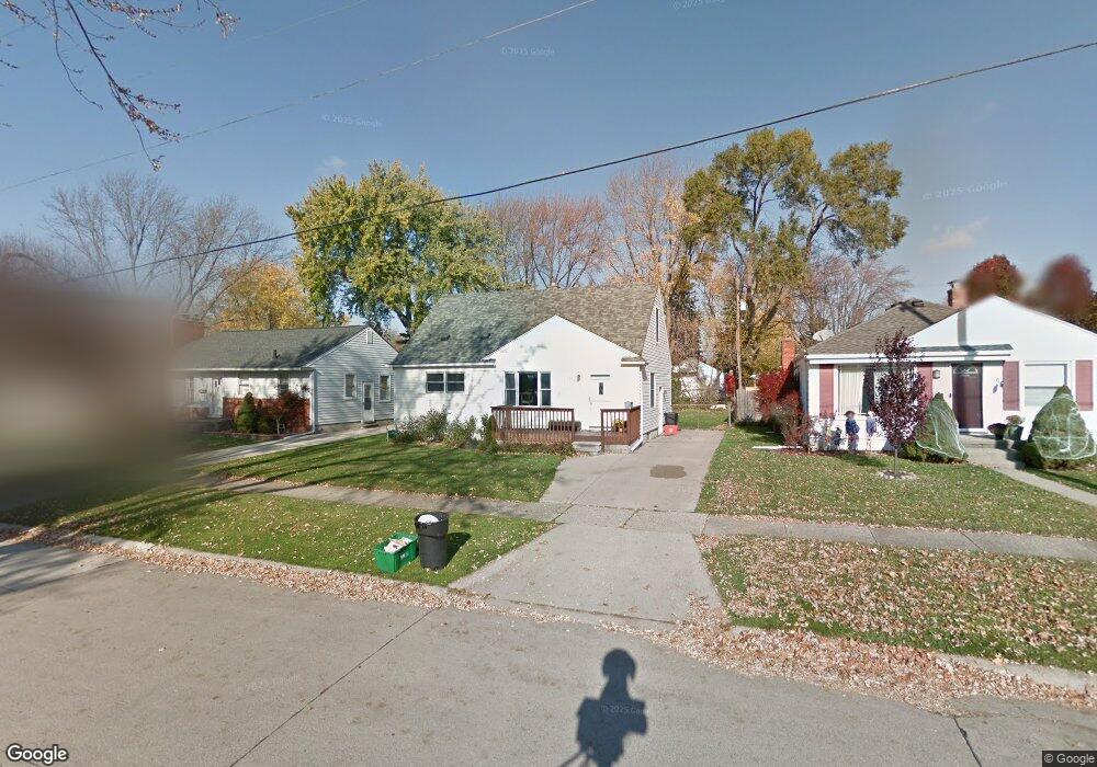
134 Tecumseh St Unit Bldg-Unit Clawson, MI 48017
Estimated Value: $280,411 - $314,000
3
Beds
2
Baths
1,131
Sq Ft
$264/Sq Ft
Est. Value
About This Home
This home is located at 134 Tecumseh St Unit Bldg-Unit, Clawson, MI 48017 and is currently estimated at $298,353, approximately $263 per square foot. 134 Tecumseh St Unit Bldg-Unit is a home located in Oakland County with nearby schools including Clawson High School, Guardian Angels School, and Japhet School.
Ownership History
Date
Name
Owned For
Owner Type
Purchase Details
Closed on
Jun 8, 2018
Sold by
Petzel John S and Petzel Kaylyn
Bought by
314 316 S Broad Llc and 401 S Saginaw Llc
Current Estimated Value
Purchase Details
Closed on
Dec 18, 1998
Sold by
Colling David W
Bought by
Petzel John S
Home Financials for this Owner
Home Financials are based on the most recent Mortgage that was taken out on this home.
Original Mortgage
$62,000
Interest Rate
6.76%
Purchase Details
Closed on
Jun 30, 1997
Sold by
Grant Eleanor Ruth
Bought by
Colling David W
Create a Home Valuation Report for This Property
The Home Valuation Report is an in-depth analysis detailing your home's value as well as a comparison with similar homes in the area
Home Values in the Area
Average Home Value in this Area
Purchase History
| Date | Buyer | Sale Price | Title Company |
|---|---|---|---|
| 314 316 S Broad Llc | $185,000 | None Available | |
| Petzel John S | $132,000 | -- | |
| Colling David W | $70,000 | -- |
Source: Public Records
Mortgage History
| Date | Status | Borrower | Loan Amount |
|---|---|---|---|
| Previous Owner | Petzel John S | $62,000 |
Source: Public Records
Tax History Compared to Growth
Tax History
| Year | Tax Paid | Tax Assessment Tax Assessment Total Assessment is a certain percentage of the fair market value that is determined by local assessors to be the total taxable value of land and additions on the property. | Land | Improvement |
|---|---|---|---|---|
| 2024 | $6,003 | $112,700 | $0 | $0 |
| 2023 | $5,745 | $101,470 | $0 | $0 |
| 2022 | $5,700 | $94,020 | $0 | $0 |
| 2021 | $5,565 | $88,250 | $0 | $0 |
| 2020 | $5,418 | $83,830 | $0 | $0 |
| 2019 | $5,522 | $80,360 | $0 | $0 |
| 2018 | $3,205 | $67,070 | $0 | $0 |
| 2017 | $3,066 | $64,290 | $0 | $0 |
| 2016 | $3,095 | $59,660 | $0 | $0 |
| 2015 | -- | $54,900 | $0 | $0 |
| 2014 | -- | $48,120 | $0 | $0 |
| 2011 | -- | $43,790 | $0 | $0 |
Source: Public Records
Map
Nearby Homes
- 104 Charlevoix St
- 42 Gladwin Ave
- 31 Walper Ave
- 112 Jeffrey Ave
- 308 W Tacoma St
- 407 Jeffrey Ave
- 411 W Sunnybrook Dr
- 216 Woodside Rd
- 306 Charlotte Ave
- 28 Nahma Ave
- 501 E Sunnybrook Dr
- 206 Kinross Ave
- 151 Fisher Ct
- 342 S Manitou Ave
- 306 W 13 Mile Rd
- 625 Whitcomb Ave
- 423 Woodlawn Ave
- 632 Millard Ave
- 345 Midland Blvd
- 206 E Windemere Ave
- 134 Tecumseh St
- 120 Tecumseh St
- 142 Tecumseh St
- 152 Tecumseh St
- 110 Tecumseh St
- 141 Nakota St
- 129 Nakota St
- 166 Tecumseh St
- 153 Nakota St
- 119 Nakota St
- 100 Tecumseh St
- 109 Nakota St Unit Bldg-Unit
- 109 Nakota St
- 163 Nakota St
- 125 Tecumseh St
- 141 Tecumseh St
- 119 Tecumseh St
- 149 Tecumseh St
- 90 Tecumseh St
- 111 Tecumseh St