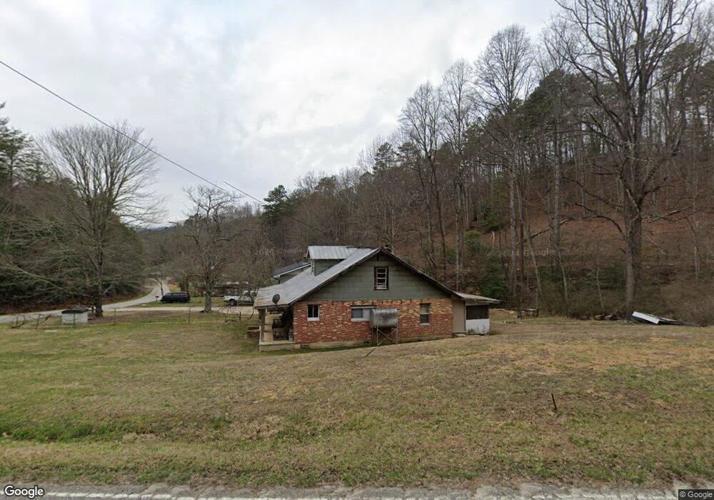
1340 Greasy Branch Rd Bryson City, NC 28713
Estimated Value: $134,000 - $143,000
2
Beds
1
Bath
1,392
Sq Ft
$99/Sq Ft
Est. Value
About This Home
This home is located at 1340 Greasy Branch Rd, Bryson City, NC 28713 and is currently estimated at $138,500, approximately $99 per square foot. 1340 Greasy Branch Rd is a home located in Swain County with nearby schools including Swain County Middle School, Swain County West Elementary School, and Swain County High School.
Ownership History
Date
Name
Owned For
Owner Type
Purchase Details
Closed on
Jan 23, 2015
Sold by
Godfrey Jeffrey Paul and Godfrey Deborah Thomas
Bought by
Godfrey Jeffrey Paul
Current Estimated Value
Purchase Details
Closed on
Oct 10, 2014
Sold by
Godfrey Jeffrey Paul
Bought by
Godfrey Jeffrey Paul and Godfrey Deborah Thomas
Purchase Details
Closed on
May 9, 2014
Sold by
Burchfield Arla Jean Godfrey and Burchfield Stanley
Bought by
Godfrey Leremy Paul and Godfrey Holly Sandvik
Create a Home Valuation Report for This Property
The Home Valuation Report is an in-depth analysis detailing your home's value as well as a comparison with similar homes in the area
Home Values in the Area
Average Home Value in this Area
Purchase History
| Date | Buyer | Sale Price | Title Company |
|---|---|---|---|
| Godfrey Jeffrey Paul | -- | None Available | |
| Godfrey Jeffrey Paul | -- | None Available | |
| Godfrey Leremy Paul | -- | None Available |
Source: Public Records
Tax History Compared to Growth
Tax History
| Year | Tax Paid | Tax Assessment Tax Assessment Total Assessment is a certain percentage of the fair market value that is determined by local assessors to be the total taxable value of land and additions on the property. | Land | Improvement |
|---|---|---|---|---|
| 2025 | $332 | $52,970 | $12,000 | $40,970 |
| 2024 | $332 | $52,970 | $12,000 | $40,970 |
| 2023 | $306 | $52,970 | $12,000 | $40,970 |
| 2022 | $306 | $52,970 | $12,000 | $40,970 |
| 2021 | $122 | $52,970 | $0 | $0 |
| 2020 | $245 | $47,240 | $25,000 | $22,240 |
| 2019 | $245 | $47,240 | $25,000 | $22,240 |
| 2018 | $245 | $47,240 | $25,000 | $22,240 |
| 2017 | $245 | $47,240 | $25,000 | $22,240 |
| 2016 | $98 | $47,240 | $25,000 | $22,240 |
| 2015 | -- | $47,240 | $25,000 | $22,240 |
| 2014 | -- | $47,240 | $25,000 | $22,240 |
Source: Public Records
Map
Nearby Homes
- 0 Rusty's Ridge Rd
- Lot 22 Rusty's Ridge Rd
- Lot 22 Rustys Ridge
- 0 Rustys Ridge
- 275 Conard Cir
- 0 Greasy Branch Rd
- 116 R P Stephenson Dr
- 77 Nash Trail
- Lot 8 Blackberry Hill
- 2130 Round Hill Rd
- 860 Butternut Ridge
- 84 Pelohi Cove Rd
- Lot 6 Butternut Ridge
- Lot 5 Butternut Ridge
- Lot 4 Butternut Ridge
- Lot 9 Butternut Ridge
- Lot 7 Butternut Ridge
- Lot 2 Butternut Ridge
- Lot 1 Butternut Ridge
- 6541 Grassy Branch Rd
- 1360 Greasy Branch Rd
- 1390 Greasy Branch Rd
- 1572 Rusty's Ridge
- 1420 Greasy Branch Rd
- 1424 Greasy Branch Rd
- 1440 Greasy Branch Rd
- 1450 Greasy Branch Rd
- 76 Mountain Top Rd
- 1480 Greasy Branch Rd
- 1459 Greasy Branch Rd
- 24 Rustys Ridge
- 24 Rusty's Ridge
- 2 Greasy Branch Rd
- 1 Greasy Branch Rd
- 9 Greasy Branch Rd
- 7 Greasy Branch Rd
- 6 Greasy Branch Rd
- 8 Greasy Branch Rd
- 5 Greasy Branch Rd
- 3 Greasy Branch Rd