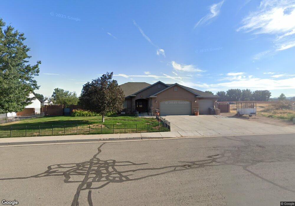
1340 W 325 S Parowan, UT 84761
3
Beds
3
Baths
2,392
Sq Ft
0.36
Acres
About This Home
This home is located at 1340 W 325 S, Parowan, UT 84761. 1340 W 325 S is a home located in Iron County with nearby schools including Parowan School, Parowan High School, and Cedar City High School.
Ownership History
Date
Name
Owned For
Owner Type
Purchase Details
Closed on
Jan 19, 2011
Sold by
Federal Home Loan Mortgage Corporation
Bought by
Badgett Billie Don and Badgett Ronalyn
Purchase Details
Closed on
Oct 25, 2010
Sold by
Applegate Russell
Bought by
Federal Home Loan Mortgage Corporation
Purchase Details
Closed on
Mar 10, 2006
Sold by
Church Joey and Smith Taylor K
Bought by
Applegate Russell
Home Financials for this Owner
Home Financials are based on the most recent Mortgage that was taken out on this home.
Original Mortgage
$39,001
Interest Rate
6.08%
Mortgage Type
Purchase Money Mortgage
Purchase Details
Closed on
Oct 26, 2005
Sold by
Smith James Lavae and James Lavae Smith Family Trust
Bought by
Church Joey and Smith Taylor K
Create a Home Valuation Report for This Property
The Home Valuation Report is an in-depth analysis detailing your home's value as well as a comparison with similar homes in the area
Home Values in the Area
Average Home Value in this Area
Purchase History
| Date | Buyer | Sale Price | Title Company |
|---|---|---|---|
| Badgett Billie Don | -- | First American Title Ins Co | |
| Federal Home Loan Mortgage Corporation | $232,000 | Etitle Ins Agency | |
| Applegate Russell | -- | -- | |
| Church Joey | -- | -- |
Source: Public Records
Mortgage History
| Date | Status | Borrower | Loan Amount |
|---|---|---|---|
| Previous Owner | Applegate Russell | $39,001 |
Source: Public Records
Tax History Compared to Growth
Tax History
| Year | Tax Paid | Tax Assessment Tax Assessment Total Assessment is a certain percentage of the fair market value that is determined by local assessors to be the total taxable value of land and additions on the property. | Land | Improvement |
|---|---|---|---|---|
| 2025 | $2,559 | $317,615 | $41,434 | $276,181 |
| 2023 | $2,472 | $345,825 | $41,435 | $304,390 |
| 2022 | $2,789 | $291,320 | $37,665 | $253,655 |
| 2021 | $1,979 | $206,725 | $18,830 | $187,895 |
| 2020 | $1,838 | $169,560 | $16,080 | $153,480 |
| 2019 | $1,712 | $150,720 | $16,080 | $134,640 |
| 2018 | $1,725 | $148,625 | $13,985 | $134,640 |
| 2017 | $1,547 | $130,000 | $12,730 | $117,270 |
| 2016 | $1,497 | $119,150 | $12,730 | $106,420 |
| 2015 | $1,372 | $103,140 | $0 | $0 |
| 2014 | $1,474 | $105,735 | $0 | $0 |
Source: Public Records
Map
Nearby Homes
- 377 1375 W
- 403 & 404 Kari
- 1435 W 200 S Unit 315
- 1112 W 275 S
- 257 S 1175 W
- 1144 375 South St
- 0 W Old Highway 91 Unit 24-253616
- 0 W Old Highway 91 Unit 108031
- 680 S Heritage Hills Dr
- 1025 W Old Highway 91
- 704 S Heritage Hills Dr
- 273 700 W
- 114 N 850 W
- 1521 W 950 S
- 0 Lot 2 Blk 8 Plat C Unit 108795
- 6.81 ACFT Water Right: 75-251 Unit 1915 Priority
- 1.73 AF Water Right ~ #75-1
- 0 968 S 1650 W Unit 25-264445
- 755 W 130 N
- 7.13 Acres Commercial Land