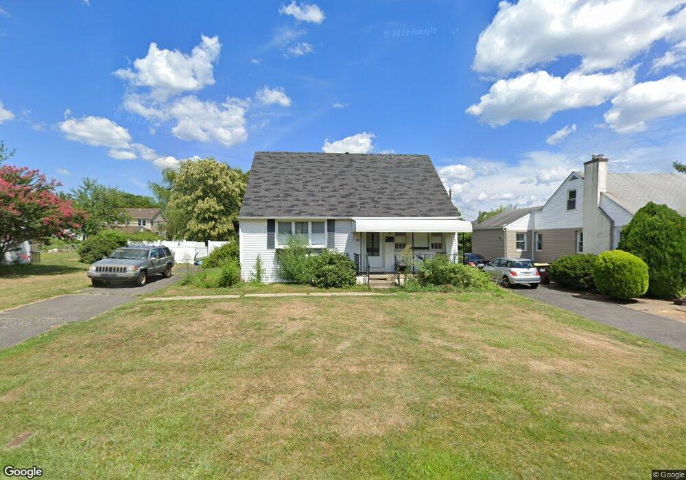
1341 Corry Ave Bensalem, PA 19020
Estimated Value: $323,000 - $379,000
3
Beds
1
Bath
1,080
Sq Ft
$315/Sq Ft
Est. Value
About This Home
This home is located at 1341 Corry Ave, Bensalem, PA 19020 and is currently estimated at $340,537, approximately $315 per square foot. 1341 Corry Ave is a home located in Bucks County with nearby schools including Robert K. Shafer Middle School, School Lane Charter School, and St Charles Borromeo School.
Ownership History
Date
Name
Owned For
Owner Type
Purchase Details
Closed on
Dec 5, 2014
Sold by
Jones Linda Kane
Bought by
Sheppard Duncan
Current Estimated Value
Home Financials for this Owner
Home Financials are based on the most recent Mortgage that was taken out on this home.
Original Mortgage
$153,225
Outstanding Balance
$117,629
Interest Rate
3.98%
Mortgage Type
VA
Estimated Equity
$222,908
Purchase Details
Closed on
Nov 5, 1958
Bought by
Kane Francis J and Kane Frances C
Create a Home Valuation Report for This Property
The Home Valuation Report is an in-depth analysis detailing your home's value as well as a comparison with similar homes in the area
Home Values in the Area
Average Home Value in this Area
Purchase History
| Date | Buyer | Sale Price | Title Company |
|---|---|---|---|
| Sheppard Duncan | $150,000 | Westcor Land Title Ins Co | |
| Kane Francis J | -- | -- |
Source: Public Records
Mortgage History
| Date | Status | Borrower | Loan Amount |
|---|---|---|---|
| Open | Sheppard Duncan | $153,225 |
Source: Public Records
Tax History Compared to Growth
Tax History
| Year | Tax Paid | Tax Assessment Tax Assessment Total Assessment is a certain percentage of the fair market value that is determined by local assessors to be the total taxable value of land and additions on the property. | Land | Improvement |
|---|---|---|---|---|
| 2025 | $3,144 | $14,400 | $3,840 | $10,560 |
| 2024 | $3,144 | $14,400 | $3,840 | $10,560 |
| 2023 | $3,055 | $14,400 | $3,840 | $10,560 |
| 2022 | $3,037 | $14,400 | $3,840 | $10,560 |
| 2021 | $3,037 | $14,400 | $3,840 | $10,560 |
| 2020 | $3,006 | $14,400 | $3,840 | $10,560 |
| 2019 | $2,939 | $14,400 | $3,840 | $10,560 |
| 2018 | $2,871 | $14,400 | $3,840 | $10,560 |
| 2017 | $2,853 | $14,400 | $3,840 | $10,560 |
| 2016 | $2,853 | $14,400 | $3,840 | $10,560 |
| 2015 | -- | $14,400 | $3,840 | $10,560 |
| 2014 | -- | $14,400 | $3,840 | $10,560 |
Source: Public Records
Map
Nearby Homes
- 2387 Forrest Ave
- 1319 Rosalie Ave
- 1742 Paradise Ln
- 1032 Sunset Ln
- 1155 Regina Ave
- 1421 Custom House Square
- 943 Cornwells Ave
- 2498 Ogden Ave
- 2209 Dungan Ave
- 833 Simons Ave
- 4471 Ernie Davis Cir
- 4274 Lawnside Rd
- 2692 June Ave
- 11913 Millbrook Rd
- 4207 Fairdale Rd
- 4208 Greenmount Rd
- 12603 Biscayne Dr
- 4122 Fairdale Rd
- 12614 Biscayne Dr
- 3785 Genesee Dr
- 1335 Corry Ave
- 1357 Corry Ave
- 2072 Hulmeville Rd
- 2056 Hulmeville Rd
- 1365 Corry Ave
- 1320 Cornwells Ave
- 2084 Hulmeville Rd
- 1348 Corry Ave
- 1332 Corry Ave
- 2042 Hulmeville Rd
- 1322 Corry Ave
- 1358 Corry Ave
- 1373 Corry Ave
- 1320 Corry Ave
- 1340 Cornwells Ave
- 2028 Hulmeville Rd
- 1370 Corry Ave
- 1280 Cornwells Ave
- 1385 Corry Ave
- 2051 Hulmeville Rd