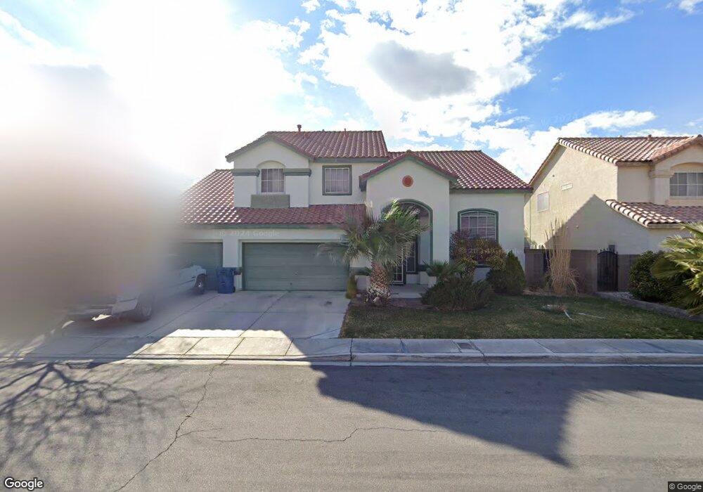
1341 Lime Point St Las Vegas, NV 89110
Estimated Value: $582,008 - $651,000
4
Beds
3
Baths
3,188
Sq Ft
$194/Sq Ft
Est. Value
About This Home
This home is located at 1341 Lime Point St, Las Vegas, NV 89110 and is currently estimated at $618,502, approximately $194 per square foot. 1341 Lime Point St is a home located in Clark County with nearby schools including Eileen Brookman Elementary School, Dr. William H. Bailey Middle School, and Eldorado High School.
Ownership History
Date
Name
Owned For
Owner Type
Purchase Details
Closed on
Dec 28, 1998
Sold by
Robinson Michael Claude
Bought by
Ghigi Mary C and Cervantes Sergio
Current Estimated Value
Home Financials for this Owner
Home Financials are based on the most recent Mortgage that was taken out on this home.
Original Mortgage
$62,000
Interest Rate
6.82%
Purchase Details
Closed on
Aug 1, 1997
Sold by
U S Home Corp
Bought by
Robinson Michael Claude
Create a Home Valuation Report for This Property
The Home Valuation Report is an in-depth analysis detailing your home's value as well as a comparison with similar homes in the area
Home Values in the Area
Average Home Value in this Area
Purchase History
| Date | Buyer | Sale Price | Title Company |
|---|---|---|---|
| Ghigi Mary C | $212,000 | First American Title Co | |
| Robinson Michael Claude | $201,500 | Stewart Title |
Source: Public Records
Mortgage History
| Date | Status | Borrower | Loan Amount |
|---|---|---|---|
| Closed | Ghigi Mary C | $62,000 |
Source: Public Records
Tax History Compared to Growth
Tax History
| Year | Tax Paid | Tax Assessment Tax Assessment Total Assessment is a certain percentage of the fair market value that is determined by local assessors to be the total taxable value of land and additions on the property. | Land | Improvement |
|---|---|---|---|---|
| 2025 | $2,082 | $147,317 | $34,650 | $112,667 |
| 2024 | $2,022 | $147,317 | $34,650 | $112,667 |
| 2023 | $2,022 | $144,047 | $36,750 | $107,297 |
| 2022 | $1,966 | $128,368 | $30,100 | $98,268 |
| 2021 | $1,953 | $118,512 | $24,850 | $93,662 |
| 2020 | $1,851 | $120,354 | $27,300 | $93,054 |
| 2019 | $1,797 | $116,395 | $24,500 | $91,895 |
| 2018 | $1,784 | $108,229 | $19,950 | $88,279 |
| 2017 | $2,873 | $97,969 | $18,900 | $79,069 |
| 2016 | $1,690 | $82,858 | $13,300 | $69,558 |
| 2015 | $1,686 | $72,590 | $10,500 | $62,090 |
| 2014 | $1,637 | $54,152 | $7,000 | $47,152 |
Source: Public Records
Map
Nearby Homes
- 1330 Honey Lake St
- 1239 N Hollywood Blvd
- 6502 Bristle Canyon Ave
- 1250 Bobrich Cir
- 1345 Morning Sun Way
- 1166 Panorama Heights St
- 6435 Heatherton Ave
- 1295 Los Meadows Dr
- 1251 Los Meadows Dr
- 2085 N Hollywood Blvd
- 1083 Sterling Peak St
- 6205 Seaside Park Ave
- 1030 Pearl Peak St
- 1083 Devon Lake St
- 6165 Stanley Park Ave
- 6449 Elizabethtown Ave
- 6271 Brynhurst Dr
- 1086 Eastridge Way
- 6182 Morning Splendor Way
- 6538 Astorville Ct
- 1321 Lime Point St
- 1365 Lime Point St
- 6555 Stormy Sky Ave
- 6630 Abbeywood Dr
- 1301 Lime Point St
- 1330 Lime Point St
- 1350 Lime Point St Unit 2
- 1310 Lime Point St
- 1300 Mound House St
- 1370 Lime Point St Unit 1
- 6600 Abbeywood Dr
- 1397 Lime Point St
- 1287 Lime Point St
- 1290 Lime Point St
- 6554 Stormy Sky Ave
- 6531 Stormy Sky Ave
- 1331 Honey Lake St
- 1351 Honey Lake St
- 1294 Mound House St
- 1311 Honey Lake St