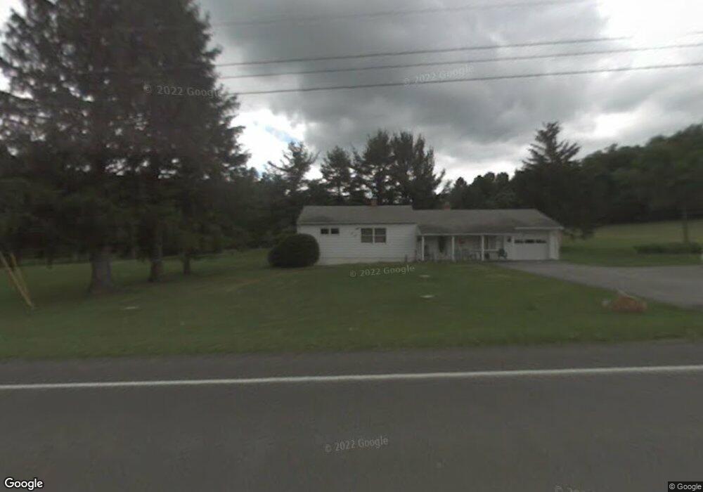
13422 Route 28 Brockway, PA 15824
Estimated Value: $130,000 - $168,000
--
Bed
--
Bath
788
Sq Ft
$196/Sq Ft
Est. Value
About This Home
This home is located at 13422 Route 28, Brockway, PA 15824 and is currently estimated at $154,330, approximately $195 per square foot. 13422 Route 28 is a home located in Jefferson County with nearby schools including Brockway Area Elementary School, Brockway Area Junior/Senior High School, and Hillside School.
Ownership History
Date
Name
Owned For
Owner Type
Purchase Details
Closed on
Mar 16, 2010
Sold by
Foeks Leland C
Bought by
Buttery Suzane M
Current Estimated Value
Purchase Details
Closed on
Jul 17, 2009
Sold by
Foeks Leland C and Foeks Cheryl
Bought by
Foeks Leland C
Purchase Details
Closed on
Dec 29, 2006
Sold by
Buttery Suzane M
Bought by
Foeks Leland C and Delp Lisa
Purchase Details
Closed on
Dec 19, 2006
Sold by
Buttery Suzane M
Bought by
Department Of Transportation
Create a Home Valuation Report for This Property
The Home Valuation Report is an in-depth analysis detailing your home's value as well as a comparison with similar homes in the area
Home Values in the Area
Average Home Value in this Area
Purchase History
| Date | Buyer | Sale Price | Title Company |
|---|---|---|---|
| Buttery Suzane M | $3,100 | None Available | |
| Foeks Leland C | -- | None Available | |
| Foeks Leland C | $3,100 | None Available | |
| Department Of Transportation | -- | None Available |
Source: Public Records
Tax History Compared to Growth
Tax History
| Year | Tax Paid | Tax Assessment Tax Assessment Total Assessment is a certain percentage of the fair market value that is determined by local assessors to be the total taxable value of land and additions on the property. | Land | Improvement |
|---|---|---|---|---|
| 2025 | $1,871 | $48,240 | $6,440 | $41,800 |
| 2024 | $2,193 | $48,240 | $6,440 | $41,800 |
| 2023 | $1,823 | $48,240 | $6,440 | $41,800 |
| 2022 | $1,823 | $48,240 | $6,440 | $41,800 |
| 2021 | $1,823 | $48,240 | $6,440 | $41,800 |
| 2020 | $1,823 | $48,240 | $6,440 | $41,800 |
| 2019 | $1,743 | $48,240 | $6,440 | $41,800 |
| 2018 | $1,698 | $48,240 | $6,440 | $41,800 |
| 2017 | $1,672 | $48,240 | $6,440 | $41,800 |
| 2016 | $1,522 | $48,240 | $6,440 | $41,800 |
| 2015 | -- | $48,240 | $6,440 | $41,800 |
| 2012 | -- | $48,240 | $6,440 | $41,800 |
Source: Public Records
Map
Nearby Homes
- 19 Salandra Ln
- 0 Coal Glen Rd
- 1074 10th Ave
- 970 Baghdad Rd
- 1549 Main St
- 0 U S 219
- 924 Elm St
- 5546 Stevenson Hill Rd
- 7956 U S 219
- 00 Pennsylvania 830
- 425 Zuccolotto Ln
- 725 Russel Rd
- 1083 Rattlesnake Rd
- 3539 Stevenson Hill Rd
- 5850 U S 219
- 559 Buskirk Rd
- 3243 Stevenson Hill Rd
- 1032 Beechtree Rd
- 10217 Pennsylvania 28
- 101 Howard Rd