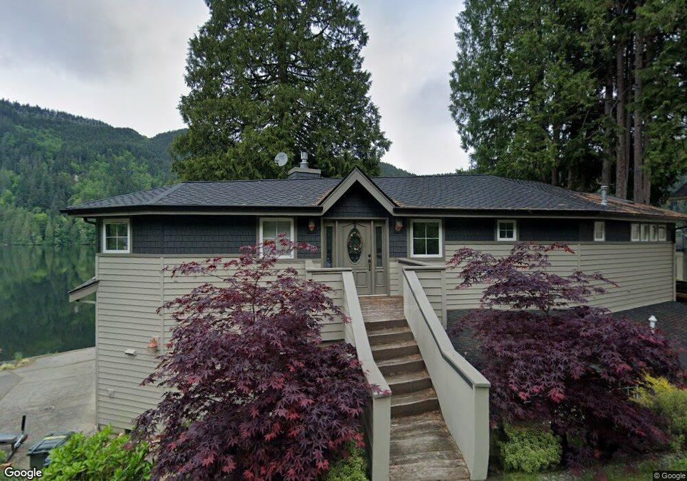
1344 Roy Rd Bellingham, WA 98229
Estimated Value: $1,109,000 - $1,762,000
3
Beds
2
Baths
2,838
Sq Ft
$536/Sq Ft
Est. Value
About This Home
This home is located at 1344 Roy Rd, Bellingham, WA 98229 and is currently estimated at $1,522,228, approximately $536 per square foot. 1344 Roy Rd is a home located in Whatcom County with nearby schools including Wade King Elementary School, Fairhaven Middle School, and Sehome High School.
Ownership History
Date
Name
Owned For
Owner Type
Purchase Details
Closed on
Dec 13, 2024
Sold by
Morris Robby Rob A and Morris Sandra L
Bought by
Robby And Sandra Morris Living Trust and Morris
Current Estimated Value
Purchase Details
Closed on
Jun 27, 2016
Sold by
Lindberg Steven
Bought by
Morris Robby A and Morris Sandra L
Home Financials for this Owner
Home Financials are based on the most recent Mortgage that was taken out on this home.
Original Mortgage
$417,000
Interest Rate
3.66%
Mortgage Type
New Conventional
Purchase Details
Closed on
Apr 19, 2002
Sold by
Bank Of New York
Bought by
Lindberg Steven
Home Financials for this Owner
Home Financials are based on the most recent Mortgage that was taken out on this home.
Original Mortgage
$248,000
Interest Rate
3.37%
Purchase Details
Closed on
Apr 12, 2002
Sold by
Lindberg Maria
Bought by
Lindberg Steven
Home Financials for this Owner
Home Financials are based on the most recent Mortgage that was taken out on this home.
Original Mortgage
$248,000
Interest Rate
3.37%
Purchase Details
Closed on
Apr 25, 2001
Sold by
Anders Marc Alan and Anders Linda R Stephens
Bought by
Bank Of New York
Create a Home Valuation Report for This Property
The Home Valuation Report is an in-depth analysis detailing your home's value as well as a comparison with similar homes in the area
Home Values in the Area
Average Home Value in this Area
Purchase History
| Date | Buyer | Sale Price | Title Company |
|---|---|---|---|
| Robby And Sandra Morris Living Trust | $313 | None Listed On Document | |
| Robby And Sandra Morris Living Trust | $313 | None Listed On Document | |
| Morris Robby A | $610,000 | Whatcom Land Title | |
| Lindberg Steven | $266,460 | Chicago Title Insurance | |
| Lindberg Steven | -- | Chicago Title Insurance | |
| Bank Of New York | $303,750 | First American Title Insuran |
Source: Public Records
Mortgage History
| Date | Status | Borrower | Loan Amount |
|---|---|---|---|
| Previous Owner | Morris Robby A | $417,000 | |
| Previous Owner | Lindberg Steven | $248,000 |
Source: Public Records
Tax History Compared to Growth
Tax History
| Year | Tax Paid | Tax Assessment Tax Assessment Total Assessment is a certain percentage of the fair market value that is determined by local assessors to be the total taxable value of land and additions on the property. | Land | Improvement |
|---|---|---|---|---|
| 2024 | $12,551 | $1,441,315 | $930,522 | $510,793 |
| 2023 | $12,551 | $1,492,846 | $963,790 | $529,056 |
| 2022 | $10,825 | $1,270,514 | $820,251 | $450,263 |
| 2021 | $9,651 | $1,024,636 | $661,511 | $363,125 |
| 2020 | $9,448 | $898,796 | $580,268 | $318,528 |
| 2019 | $8,913 | $853,152 | $550,800 | $302,352 |
| 2018 | $9,286 | $808,169 | $511,461 | $296,708 |
| 2017 | $8,203 | $717,361 | $453,988 | $263,373 |
| 2016 | $7,431 | $660,394 | $417,727 | $242,667 |
| 2015 | $7,291 | $626,214 | $395,970 | $230,244 |
| 2014 | -- | $596,384 | $377,114 | $219,270 |
| 2013 | -- | $569,664 | $362,610 | $207,054 |
Source: Public Records
Map
Nearby Homes
- 961 W Lake Samish Dr
- 715 Samish Heights Ln
- 665 Samish Ln
- 921 Autumn Ln Unit 221
- 921 Autumn Ln Unit 205
- 921 Autumn Ln Unit 243
- 471 Summerland Rd
- 562 W Lake Samish Dr
- 0 Stoney Brook Ln
- 486 W Lake Samish Dr
- 4476 Stoney Brook Ln
- 0 XXXX Stoney Brook Ln Unit E 6-7
- 316 W Lake Samish Dr Unit 35
- 316 W Lake Samish Dr Unit 21
- 316 W Lake Samish Dr
- 125 Summerland Rd
- 550 Manley Rd
- 268 Friday Creek Rd
- 322 Manley Rd
- 4949 Samish Way Unit 17