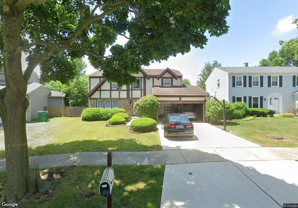
1345 Devonshire Rd Buffalo Grove, IL 60089
Prairie Park-Lake County NeighborhoodEstimated Value: $516,400 - $628,000
Studio
3
Baths
2,199
Sq Ft
$263/Sq Ft
Est. Value
About This Home
This home is located at 1345 Devonshire Rd, Buffalo Grove, IL 60089 and is currently estimated at $577,850, approximately $262 per square foot. 1345 Devonshire Rd is a home located in Lake County with nearby schools including Prairie Elementary School, Twin Groves Middle School, and Adlai E Stevenson High School.
Ownership History
Date
Name
Owned For
Owner Type
Purchase Details
Closed on
Jun 30, 2000
Sold by
Stoller Randy S
Bought by
Friedman Craig and Friedman Dana
Current Estimated Value
Home Financials for this Owner
Home Financials are based on the most recent Mortgage that was taken out on this home.
Original Mortgage
$150,000
Outstanding Balance
$55,232
Interest Rate
8.64%
Estimated Equity
$522,618
Create a Home Valuation Report for This Property
The Home Valuation Report is an in-depth analysis detailing your home's value as well as a comparison with similar homes in the area
Home Values in the Area
Average Home Value in this Area
Purchase History
| Date | Buyer | Sale Price | Title Company |
|---|---|---|---|
| Friedman Craig | $300,000 | Chicago Title Insurance Co |
Source: Public Records
Mortgage History
| Date | Status | Borrower | Loan Amount |
|---|---|---|---|
| Open | Friedman Craig | $150,000 |
Source: Public Records
Tax History
| Year | Tax Paid | Tax Assessment Tax Assessment Total Assessment is a certain percentage of the fair market value that is determined by local assessors to be the total taxable value of land and additions on the property. | Land | Improvement |
|---|---|---|---|---|
| 2024 | $14,225 | $155,445 | $34,108 | $121,337 |
| 2023 | $13,480 | $146,673 | $32,183 | $114,490 |
| 2022 | $13,480 | $135,280 | $29,683 | $105,597 |
| 2021 | $12,970 | $133,821 | $29,363 | $104,458 |
| 2020 | $12,664 | $134,277 | $29,463 | $104,814 |
| 2019 | $12,490 | $133,782 | $29,354 | $104,428 |
| 2018 | $12,138 | $134,135 | $29,011 | $105,124 |
| 2017 | $11,908 | $131,004 | $28,334 | $102,670 |
| 2016 | $11,598 | $125,447 | $27,132 | $98,315 |
| 2015 | $11,292 | $117,317 | $25,374 | $91,943 |
| 2014 | $10,246 | $105,557 | $27,251 | $78,306 |
| 2012 | $10,169 | $105,769 | $27,306 | $78,463 |
Source: Public Records
Map
Nearby Homes
- 1152 Courtland Dr Unit 406
- 1328 Larchmont Dr
- 1234 Devonshire Rd
- 1161 Parker Ln
- 1135 Thompson Blvd
- 962 Thompson Blvd
- 1265 Devonshire Rd
- 5107 N Arlington Heights Rd
- 1318 Gail Dr Unit 4
- 1217 Franklin Ln Unit G5
- 5152 Bridlewood Ln
- 327 Lasalle Ln
- 5176 Aptakisic Rd
- 810 Silver Rock Ln
- 736 Clohesey Dr
- 5135 Bridlewood Ct
- 1005 Cooper Ct
- 711 Woodhollow Ln
- 1548 Bunescu Ct
- 924 Shambliss Ln
- 1343 Devonshire Rd
- 1347 Devonshire Rd
- 1341 Devonshire Rd
- 1349 Devonshire Rd Unit 2
- 1344 Devonshire Rd
- 1339 Devonshire Rd
- 1342 Devonshire Rd
- 1350 Devonshire Rd
- 1351 Devonshire Rd
- 1215 Ranch View Ct Unit 2
- 1217 Ranch View Ct Unit 2
- 1217 Ranchview Ct
- 1217 Ranch View Ct Unit 1217
- 1217 Ranchview Ct Unit 1217
- 1213 Ranch View Ct Unit 2
- 1219 Ranch View Ct Unit 2
- 1211 Ranch View Ct Unit 2
- 1221 Ranch View Ct
- 1221 Ranchview Ct
- 1223 Ranch View Ct Unit 2
Your Personal Tour Guide
Ask me questions while you tour the home.