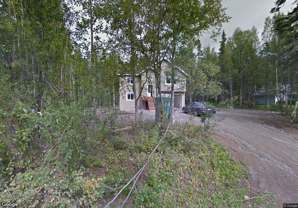
1345 E Brant Cir Wasilla, AK 99654
Estimated Value: $194,000 - $379,705
--
Bed
--
Bath
658
Sq Ft
$445/Sq Ft
Est. Value
About This Home
This home is located at 1345 E Brant Cir, Wasilla, AK 99654 and is currently estimated at $292,676, approximately $444 per square foot. 1345 E Brant Cir is a home located in Matanuska-Susitna Borough with nearby schools including Larson Elementary School, Teeland Middle School, and Colony High School.
Ownership History
Date
Name
Owned For
Owner Type
Purchase Details
Closed on
Nov 2, 2011
Sold by
Fletchers Construction Inc
Bought by
Teel Aaislinn B and Teel Robert D
Current Estimated Value
Home Financials for this Owner
Home Financials are based on the most recent Mortgage that was taken out on this home.
Original Mortgage
$203,877
Outstanding Balance
$139,024
Interest Rate
4.02%
Mortgage Type
New Conventional
Estimated Equity
$153,652
Purchase Details
Closed on
Apr 30, 2004
Sold by
Estate Of Bertha Linthicum and Linthicum Kerry
Bought by
Fletchers Construction Inc
Create a Home Valuation Report for This Property
The Home Valuation Report is an in-depth analysis detailing your home's value as well as a comparison with similar homes in the area
Home Values in the Area
Average Home Value in this Area
Purchase History
| Date | Buyer | Sale Price | Title Company |
|---|---|---|---|
| Teel Aaislinn B | -- | Mat Su Title Ins Agency Inc | |
| Fletchers Construction Inc | -- | -- |
Source: Public Records
Mortgage History
| Date | Status | Borrower | Loan Amount |
|---|---|---|---|
| Open | Teel Aaislinn B | $203,877 |
Source: Public Records
Tax History Compared to Growth
Tax History
| Year | Tax Paid | Tax Assessment Tax Assessment Total Assessment is a certain percentage of the fair market value that is determined by local assessors to be the total taxable value of land and additions on the property. | Land | Improvement |
|---|---|---|---|---|
| 2025 | $4,242 | $347,600 | $23,000 | $324,600 |
| 2024 | $4,242 | $334,700 | $23,000 | $311,700 |
| 2023 | $3,713 | $302,300 | $23,000 | $279,300 |
| 2022 | $3,600 | $274,500 | $23,000 | $251,500 |
| 2021 | $3,584 | $246,900 | $23,000 | $223,900 |
| 2020 | $3,421 | $228,500 | $23,000 | $205,500 |
| 2019 | $3,347 | $221,700 | $23,000 | $198,700 |
| 2018 | $3,318 | $220,900 | $23,000 | $197,900 |
| 2017 | $3,300 | $219,700 | $23,000 | $196,700 |
| 2016 | $3,174 | $216,700 | $20,000 | $196,700 |
| 2015 | $2,870 | $208,400 | $20,000 | $188,400 |
| 2014 | $2,870 | $208,000 | $19,000 | $189,000 |
Source: Public Records
Map
Nearby Homes
- 3701 N Gosling Dr
- 950 E Mcadoo Way
- 1300 E Brent Pointe Dr
- 1000 E Loch Ness Ct
- 4060 N Bull Moose Dr
- 3524 N Bald Eagle Dr
- 1975 E Caribou Loop
- 3474 N Wolverine Dr
- 2001 E Grizzly Bear Dr
- 4392 N David Cir
- 630 E Mcadoo Way
- 2755 N Holly Way
- 1906 E Ridgeview Dr
- 2300 E Musk Ox Cir
- 1061 E Agate Ln
- 2660 N Jasper Dr
- 900 E Burlwood Dr
- 480 E Agate Ln
- 2475 N Ravens Flight Dr
- 380 E New Field Dr
- 1345 Brant Cir
- 1375 E Brant Cir
- 1301 E Brant Cir
- 1275 E Brant Cir
- 1340 E Brant Cir
- 1370 E Brant Cir
- 1260 E Brant Cir
- 3595 N Plover
- 3555 N Snow Goose Dr
- 3655 N Snow Goose Dr
- 1255 E Brant Cir
- 1255 E Brant Cir
- 1300 E Scotwood Dr
- 3601 N Snow Goose Dr
- 3575 N Snow Goose Dr
- 3525 N Snow Goose Dr
- 1350 E Scotwood Dr
- 1400 E Scotwood Dr
- 3640 N Jaeger Cir
- 1260 E Scotwood Dr