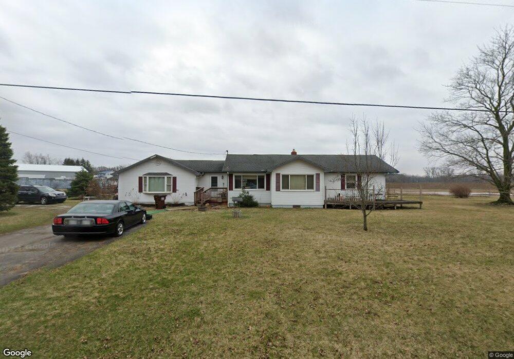
1347 Gady Rd Unit GADY Adrian, MI 49221
Estimated Value: $194,000 - $260,890
3
Beds
2
Baths
1,739
Sq Ft
$137/Sq Ft
Est. Value
About This Home
This home is located at 1347 Gady Rd Unit GADY, Adrian, MI 49221 and is currently estimated at $238,297, approximately $137 per square foot. 1347 Gady Rd Unit GADY is a home located in Lenawee County with nearby schools including Adrian High School and St. Joseph's Academy.
Ownership History
Date
Name
Owned For
Owner Type
Purchase Details
Closed on
Nov 22, 2010
Sold by
Jpmorgan Chase Bank
Bought by
Burnette David E and Burnette Elizabeth
Current Estimated Value
Home Financials for this Owner
Home Financials are based on the most recent Mortgage that was taken out on this home.
Original Mortgage
$68,128
Outstanding Balance
$44,835
Interest Rate
4.22%
Mortgage Type
New Conventional
Estimated Equity
$193,462
Purchase Details
Closed on
Sep 2, 2010
Sold by
Smalt Gary L and Smalt Connie K
Bought by
Jpmorgan Chase Bank Na
Purchase Details
Closed on
Nov 18, 2009
Sold by
Smalt Connie K
Bought by
Smalt Gary L
Create a Home Valuation Report for This Property
The Home Valuation Report is an in-depth analysis detailing your home's value as well as a comparison with similar homes in the area
Home Values in the Area
Average Home Value in this Area
Purchase History
| Date | Buyer | Sale Price | Title Company |
|---|---|---|---|
| Burnette David E | $85,160 | Title2land Llc | |
| Jpmorgan Chase Bank Na | $71,250 | None Available | |
| Smalt Gary L | -- | None Available |
Source: Public Records
Mortgage History
| Date | Status | Borrower | Loan Amount |
|---|---|---|---|
| Open | Burnette David E | $68,128 |
Source: Public Records
Tax History Compared to Growth
Tax History
| Year | Tax Paid | Tax Assessment Tax Assessment Total Assessment is a certain percentage of the fair market value that is determined by local assessors to be the total taxable value of land and additions on the property. | Land | Improvement |
|---|---|---|---|---|
| 2025 | $1,817 | $97,700 | $0 | $0 |
| 2024 | $1,110 | $94,000 | $0 | $0 |
| 2022 | $1,675 | $77,200 | $0 | $0 |
| 2021 | $1,656 | $72,600 | $0 | $0 |
| 2020 | $1,656 | $67,600 | $0 | $0 |
| 2019 | $151,253 | $62,700 | $0 | $0 |
| 2018 | $1,702 | $62,678 | $0 | $0 |
| 2017 | $1,643 | $59,941 | $0 | $0 |
| 2016 | $1,632 | $54,739 | $0 | $0 |
| 2014 | -- | $50,777 | $0 | $0 |
Source: Public Records
Map
Nearby Homes
- 4126 Mckenna Dr
- 4705 Robin Hood Trail
- 4623 N Adrian Hwy
- 5000 N Adrian Hwy
- 2000 Sutton Rd Unit Parcel C
- 2000 Sutton Rd Unit Parcel B
- 2265 Occidental Hwy
- 2765 Gady Rd
- 2771 Gady Rd
- 1000 E 1st St
- 1428 E 1st St
- 41 Bailey Dr
- 6000 Occidental Hwy Unit 6000 Blk Occidental
- 1010 W Valley Rd
- 3219 Breckel Hwy
- 3852 Tanner Marie Dr
- 3311 N Adrian Hwy
- 3811 Torin Ln Unit Parcel G
- 1000 Dinius Rd Unit 1000 Blk.
- 3508 N Wilmoth Hwy