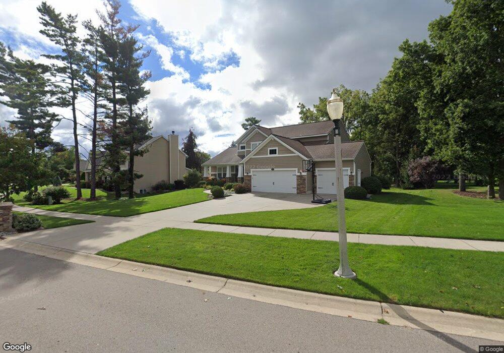
13470 Blaisdell Dr Dewitt, MI 48820
Estimated Value: $529,744 - $603,000
About This Home
This home is located at 13470 Blaisdell Dr, Dewitt, MI 48820 and is currently estimated at $551,686, approximately $500 per square foot. 13470 Blaisdell Dr is a home located in Clinton County with nearby schools including Schavey Road Elementary School, Herbison Woods Elementary School, and Scott Elementary School.
Ownership History
We collect this data history from publicly available records. To have your information removed, we recommend requesting removal directly through your county’s website.
Purchase Details
Home Financials for this Owner
Home Financials are based on the most recent Mortgage that was taken out on this home.Purchase Details
Home Values in the Area
Average Home Value in this Area
Purchase History
We collect this data history from publicly available records. To have your information removed, we recommend requesting removal directly through your county’s website.
| Date | Buyer | Sale Price | Title Company |
|---|---|---|---|
| $45,000 | First American Title Ins Co | ||
| $205,000 | None Available |
Mortgage History
We collect this data history from publicly available records. To have your information removed, we recommend requesting removal directly through your county’s website.
| Date | Status | Borrower | Loan Amount |
|---|---|---|---|
| Open | $200,000 |
Tax History
We collect this data history from publicly available records. To have your information removed, we recommend requesting removal directly through your county’s website.
| Year | Tax Paid | Tax Assessment Tax Assessment Total Assessment is a certain percentage of the fair market value that is determined by local assessors to be the total taxable value of land and additions on the property. | Land | Improvement |
|---|---|---|---|---|
| 2026 | $4,532 | $251,300 | $39,200 | $212,100 |
| 2025 | $4,532 | $241,300 | $36,600 | $204,700 |
| 2024 | $37 | $226,800 | $33,700 | $193,100 |
| 2023 | $4,177 | $203,200 | $0 | $0 |
| 2022 | $6,451 | $189,100 | $28,700 | $160,400 |
| 2021 | $6,266 | $179,700 | $27,300 | $152,400 |
| 2020 | $6,095 | $177,400 | $26,700 | $150,700 |
| 2019 | $5,859 | $174,500 | $25,100 | $149,400 |
| 2018 | $5,606 | $168,800 | $24,100 | $144,700 |
| 2017 | $5,530 | $163,200 | $23,500 | $139,700 |
| 2016 | $5,465 | $155,700 | $23,200 | $132,500 |
| 2015 | $5,477 | $149,300 | $0 | $0 |
| 2011 | -- | $20,900 | $0 | $0 |
Map
- 1507 Wellman Rd
- 13337 Tucker Dr
- 1395 Primrose Ln
- 14055 Pristine Ct
- 14065 Pristine Ct
- 14070 Pristine Ct
- 13201 Watercrest Dr
- 14054 Ambrosia Ave
- 14103 Ambrosia Ave
- 14200 Ambrosia Ave
- 12717 Houghton Dr
- 12410 Sea Pines Dr
- 1695 W Solon Rd
- 0 W Solon Rd
- 214 Ayla Dr
- 12321 Sea Pines Dr
- 238 Noleigh Ln
- 1212 Wineleaf Ln
- 606 Locust St
- 13158 Wood Rd
- 13480 Blaisdell Dr
- 13460 Blaisdell Dr
- 13490 Blaisdell Dr
- 13525 Heathrow Cir
- 13450 Blaisdell Dr
- 13441 Blaisdell Dr
- 13461 Blaisdell Dr
- 13471 Blaisdell Dr
- 13533 Heathrow Cir
- 13500 Blaisdell Dr
- 13524 Heathrow Cir
- 13440 Blaisdell Dr
- 13481 Blaisdell Dr
- 1460 Wellman Rd
- 13491 Blaisdell Dr
- 1480 Wellman Rd
- 1509 Sanborn Dr
- 1517 Sanborn Dr
- 13501 Blaisdell Dr
- 13510 Blaisdell Dr
Ask me questions while you tour the home.