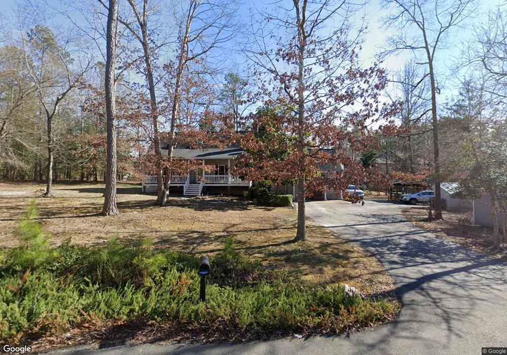
13491 Hensley Rd Midlothian, VA 23112
Estimated Value: $359,000 - $517,000
5
Beds
3
Baths
2,400
Sq Ft
$176/Sq Ft
Est. Value
About This Home
This home is located at 13491 Hensley Rd, Midlothian, VA 23112 and is currently estimated at $423,236, approximately $176 per square foot. 13491 Hensley Rd is a home located in Chesterfield County with nearby schools including Spring Run Elementary School, Bailey Bridge Middle School, and Manchester High.
Ownership History
Date
Name
Owned For
Owner Type
Purchase Details
Closed on
Nov 5, 1999
Sold by
Howerton Richard M and Howerton Adele I
Bought by
Carter Ralph S and Carter Pamela L
Current Estimated Value
Home Financials for this Owner
Home Financials are based on the most recent Mortgage that was taken out on this home.
Original Mortgage
$112,300
Outstanding Balance
$34,232
Interest Rate
7.73%
Mortgage Type
New Conventional
Estimated Equity
$389,004
Create a Home Valuation Report for This Property
The Home Valuation Report is an in-depth analysis detailing your home's value as well as a comparison with similar homes in the area
Home Values in the Area
Average Home Value in this Area
Purchase History
| Date | Buyer | Sale Price | Title Company |
|---|---|---|---|
| Carter Ralph S | $123,500 | -- |
Source: Public Records
Mortgage History
| Date | Status | Borrower | Loan Amount |
|---|---|---|---|
| Open | Carter Ralph S | $112,300 |
Source: Public Records
Tax History Compared to Growth
Tax History
| Year | Tax Paid | Tax Assessment Tax Assessment Total Assessment is a certain percentage of the fair market value that is determined by local assessors to be the total taxable value of land and additions on the property. | Land | Improvement |
|---|---|---|---|---|
| 2025 | $2,738 | $304,800 | $67,200 | $237,600 |
| 2024 | $2,738 | $291,900 | $63,400 | $228,500 |
| 2023 | $2,405 | $264,300 | $61,400 | $202,900 |
| 2022 | $2,531 | $275,100 | $57,600 | $217,500 |
| 2021 | $2,390 | $248,900 | $55,700 | $193,200 |
| 2020 | $2,262 | $238,100 | $55,700 | $182,400 |
| 2019 | $2,181 | $229,600 | $53,800 | $175,800 |
| 2018 | $2,150 | $226,300 | $53,800 | $172,500 |
| 2017 | $2,021 | $210,500 | $52,800 | $157,700 |
| 2016 | $1,926 | $200,600 | $51,800 | $148,800 |
| 2015 | $1,827 | $190,300 | $49,900 | $140,400 |
| 2014 | $1,787 | $186,100 | $48,000 | $138,100 |
Source: Public Records
Map
Nearby Homes
- 13100 Fieldfare Dr
- 14219 Ashleyville Ln
- 10001 Craftsbury Dr
- 12900 Craftsbury Ct
- 14300 Brading Ct
- 9400 Kinnerton Dr
- 10119 Cravensford Terrace
- 14412 Mission Hills Loop
- 14537 Parracombe Ln
- 13824 Brandycrest Dr
- 14536 Forest Row Trail
- 13306 Prince James Dr
- 9018 Mahogany Dr
- 9313 Mahogany Dr
- 8937 Sawgrass Place
- 10302 Teelin Ct
- 9318 Mahogany Dr
- 13800 Summerlook Ln
- 14007 Palomino Way
- 14706 Collington Turn
- 10400 Beachcrest Place
- 13496 Hensley Rd
- 13481 Hensley Rd
- 10407 Beachcrest Place
- 13490 Hensley Rd
- 13490 Spring Run Rd
- 10406 Beachcrest Place
- 13471 Hensley Rd
- 9913 Greywell Terrace
- 9907 Greywell Terrace
- 9919 Greywell Terrace
- 9901 Greywell Terrace
- 9925 Greywell Terrace
- 9825 Greywell Terrace
- 9819 Greywell Terrace
- 9931 Greywell Terrace
- 9937 Greywell Terrace
- 9813 Greywell Terrace
- 10413 Beachcrest Place
- 10412 Beachcrest Place