Estimated Value: $195,000 - $249,000
3
Beds
1
Bath
1,502
Sq Ft
$148/Sq Ft
Est. Value
About This Home
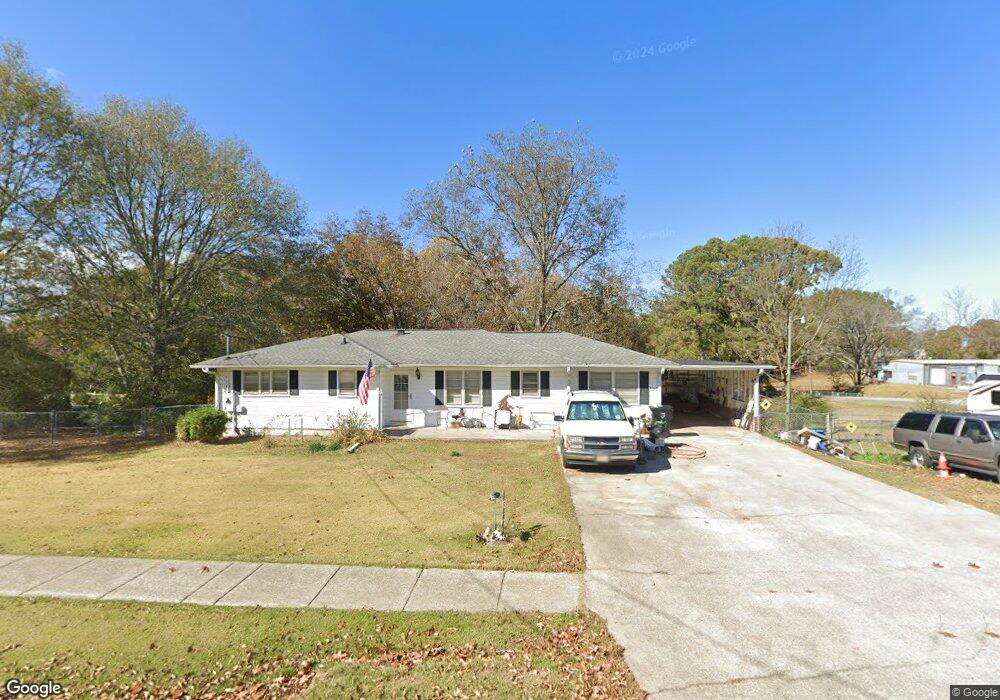
This home is located at 135 Atlantic Ave, Waco, GA 30182 and is currently estimated at $222,442, approximately $148 per square foot. 135 Atlantic Ave is a home located in Haralson County with nearby schools including Haralson County High School.
Ownership History
Date
Name
Owned For
Owner Type
Purchase Details
Closed on
Jun 1, 2009
Sold by
City Of Waco
Bought by
Anderson Susan D
Current Estimated Value
Purchase Details
Closed on
Feb 19, 2004
Sold by
Anderson Susan D
Bought by
Anderson Susan D and Anderson Ronnie L
Purchase Details
Closed on
Jan 14, 2004
Sold by
Bailey Flint I and Bailey Peggy R
Bought by
Bailey Flint I and Bailey Peggy R
Purchase Details
Closed on
Jun 27, 2002
Sold by
Parker Maggie H Estate By Garrett Gwen
Bought by
Brock Douglas and Brock Karen
Create a Home Valuation Report for This Property
The Home Valuation Report is an in-depth analysis detailing your home's value as well as a comparison with similar homes in the area
Home Values in the Area
Average Home Value in this Area
Purchase History
| Date | Buyer | Sale Price | Title Company |
|---|---|---|---|
| Anderson Susan D | -- | -- | |
| Anderson Susan D | -- | -- | |
| Anderson Susan D | $71,000 | -- | |
| Bailey Flint I | -- | -- | |
| Brock Douglas | -- | -- | |
| Bailey Flint | $52,500 | -- |
Source: Public Records
Tax History
| Year | Tax Paid | Tax Assessment Tax Assessment Total Assessment is a certain percentage of the fair market value that is determined by local assessors to be the total taxable value of land and additions on the property. | Land | Improvement |
|---|---|---|---|---|
| 2025 | $1,690 | $97,143 | $10,800 | $86,343 |
| 2024 | $1,690 | $56,117 | $5,088 | $51,029 |
| 2023 | $1,175 | $58,495 | $4,800 | $53,695 |
| 2022 | $1,327 | $47,299 | $4,800 | $42,499 |
| 2021 | $1,316 | $44,843 | $4,800 | $40,043 |
| 2020 | $1,361 | $46,265 | $4,800 | $41,465 |
| 2019 | $1,389 | $45,839 | $4,800 | $41,039 |
| 2018 | $768 | $25,853 | $4,800 | $21,053 |
| 2017 | $750 | $23,215 | $4,800 | $18,415 |
| 2016 | $894 | $31,183 | $4,800 | $26,383 |
| 2015 | $891 | $31,054 | $4,800 | $26,255 |
| 2014 | $964 | $33,932 | $7,200 | $26,732 |
Source: Public Records
Map
Nearby Homes
- 67 Depot St
- 381 King St
- 0 Blvd
- 1817 Buncombe Waco Rd
- 1830 US Highway 27
- 0 Stonebridge Blvd Unit 143588
- 0 Stonebridge Blvd Unit 7742415
- 0 Mt Zion St Unit 7399245
- 415 Mount Zion St
- 101 Bush Creek Way
- TBD Bremen Mount Zion Rd
- 111 Ayers St
- 201 Stonebridge Blvd
- 273 Sewell Rd
- 6315 Highway 78
- 1050 Waddell St
- 327 Crest Pointe S
- 321 Stonebridge Blvd
- 319 Stonebridge Blvd
- 0 Sewell Rd Unit 7665305
- 121 Atlantic Ave
- 149 Atlantic Ave
- 150 Atlantic Ave
- 138 Atlantic Ave
- 31 McBurnett St
- 158 Atlantic Ave
- 145 Wall St
- 158 Wall St
- 158 Wall St
- 164 Atlantic Ave
- 35 McBurnett St
- 176 Atlantic Ave
- 121 Wall St
- 154 Wall St
- 188 Atlantic Ave
- 79 Atlantic Ave
- 55 Commercial Ave
- 71 Atlantic Ave
- 148 Carrollton St
- 198 Atlantic Ave
Your Personal Tour Guide
Ask me questions while you tour the home.