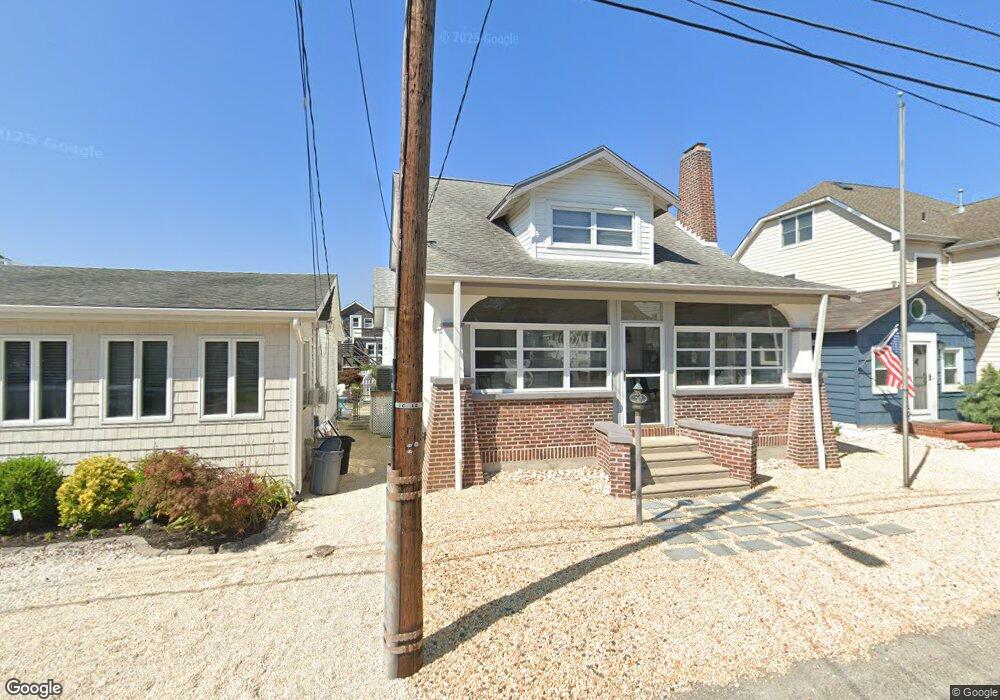
135 E Longport Ave Ocean Gate, NJ 08740
Estimated Value: $416,000 - $534,000
3
Beds
2
Baths
1,695
Sq Ft
$283/Sq Ft
Est. Value
About This Home
This home is located at 135 E Longport Ave, Ocean Gate, NJ 08740 and is currently estimated at $478,896, approximately $282 per square foot. 135 E Longport Ave is a home located in Ocean County with nearby schools including Ocean Gate Elementary School, Central Regional Middle School, and Central Regional High School.
Ownership History
Date
Name
Owned For
Owner Type
Purchase Details
Closed on
May 13, 2022
Sold by
Edward Brink Chris
Bought by
Szpila Jennifer and Szpila Christopher
Current Estimated Value
Purchase Details
Closed on
Nov 4, 2008
Sold by
Brink Edward C and Brink Edward C
Bought by
Brink Edward C
Purchase Details
Closed on
Sep 30, 2008
Sold by
Brink Edward C
Bought by
Brink Edward C and Brink Edward C
Purchase Details
Closed on
Jun 30, 1999
Sold by
Paxon Ronald Fred and Reinhard Jeanette
Bought by
Brink Edward C
Create a Home Valuation Report for This Property
The Home Valuation Report is an in-depth analysis detailing your home's value as well as a comparison with similar homes in the area
Home Values in the Area
Average Home Value in this Area
Purchase History
| Date | Buyer | Sale Price | Title Company |
|---|---|---|---|
| Szpila Jennifer | $328,000 | Kosylo John D | |
| Brink Edward C | -- | Gibraltar Title Agency Inc | |
| Brink Edward C | -- | None Available | |
| Brink Edward C | $87,000 | -- |
Source: Public Records
Tax History
| Year | Tax Paid | Tax Assessment Tax Assessment Total Assessment is a certain percentage of the fair market value that is determined by local assessors to be the total taxable value of land and additions on the property. | Land | Improvement |
|---|---|---|---|---|
| 2025 | $8,131 | $446,500 | $151,000 | $295,500 |
| 2024 | $6,313 | $446,500 | $151,000 | $295,500 |
| 2023 | $5,815 | $209,100 | $60,700 | $148,400 |
| 2022 | $5,815 | $209,100 | $60,700 | $148,400 |
| 2021 | $5,566 | $209,100 | $60,700 | $148,400 |
| 2020 | $5,610 | $209,100 | $60,700 | $148,400 |
| 2019 | $5,474 | $209,100 | $60,700 | $148,400 |
| 2018 | $5,284 | $209,100 | $60,700 | $148,400 |
| 2017 | $5,244 | $209,100 | $60,700 | $148,400 |
| 2016 | $5,202 | $209,100 | $60,700 | $148,400 |
| 2015 | $5,081 | $249,300 | $100,000 | $149,300 |
| 2014 | $5,103 | $249,300 | $100,000 | $149,300 |
Source: Public Records
Map
Nearby Homes
- 32 E Long Branch Ave
- 207 Ocean Gate Ave
- 24 W Point Pleasant Ave
- 375 E Barnegat Ave
- 36 W Point Pleasant Ave
- 319 Monmouth Ave
- 318 E Cape May Ave
- 553 Ocean Gate Dr
- 0 Jane Ave
- 2 Jane Ave
- 117 W Arverne Ave
- 3 Sheila Ct
- 39 Ivy Ct
- 277 Bayville Ave
- 521 E Long Branch Ave
- 521 E Point Pleasant Ave
- 803 Ocean Gate Dr
- 409 Newport Ave
- 243 Lakewood Ave
- 639 E Bayview Ave
- 139 E Longport Ave
- 133 E Longport Ave
- 141 E Longport Ave
- 129 E Longport Ave
- 132 E Chelsea Ave
- 125 E Longport Ave
- 130 E Chelsea Ave
- 148 E Riviera Ave
- 138 E Longport Ave
- 124 E Chelsea Ave
- 134 E Longport Ave
- 150 E Riviera Ave
- 130 E Longport Ave
- 121 E Longport Ave
- 122 E Chelsea Ave
- 142 E Longport Ave
- 142 E Longport Ave Unit 358
- 126 E Longport Ave
- 128 E Longport Ave
- 146 E Longport Ave
Your Personal Tour Guide
Ask me questions while you tour the home.