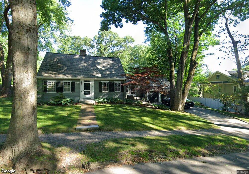
135 Fairway Rd Chestnut Hill, MA 02467
Chestnut Hill NeighborhoodEstimated Value: $1,901,000 - $2,610,000
3
Beds
3
Baths
2,009
Sq Ft
$1,058/Sq Ft
Est. Value
About This Home
This home is located at 135 Fairway Rd, Chestnut Hill, MA 02467 and is currently estimated at $2,125,363, approximately $1,057 per square foot. 135 Fairway Rd is a home located in Norfolk County with nearby schools including Heath Elementary School, Brimmer & May School, and The Chestnut Hill School.
Ownership History
Date
Name
Owned For
Owner Type
Purchase Details
Closed on
May 1, 1991
Sold by
Winslow Virginia B
Bought by
Condon Stephen H
Current Estimated Value
Home Financials for this Owner
Home Financials are based on the most recent Mortgage that was taken out on this home.
Original Mortgage
$289,800
Interest Rate
9.55%
Mortgage Type
Purchase Money Mortgage
Create a Home Valuation Report for This Property
The Home Valuation Report is an in-depth analysis detailing your home's value as well as a comparison with similar homes in the area
Home Values in the Area
Average Home Value in this Area
Purchase History
| Date | Buyer | Sale Price | Title Company |
|---|---|---|---|
| Condon Stephen H | $322,000 | -- |
Source: Public Records
Mortgage History
| Date | Status | Borrower | Loan Amount |
|---|---|---|---|
| Open | Condon Stephen H | $360,000 | |
| Closed | Condon Stephen H | $288,300 | |
| Closed | Condon Stephen H | $289,800 |
Source: Public Records
Tax History Compared to Growth
Tax History
| Year | Tax Paid | Tax Assessment Tax Assessment Total Assessment is a certain percentage of the fair market value that is determined by local assessors to be the total taxable value of land and additions on the property. | Land | Improvement |
|---|---|---|---|---|
| 2025 | $19,105 | $1,935,700 | $1,410,500 | $525,200 |
| 2024 | $18,196 | $1,862,400 | $1,356,200 | $506,200 |
| 2023 | $16,408 | $1,645,700 | $1,113,700 | $532,000 |
| 2022 | $15,972 | $1,567,400 | $1,060,700 | $506,700 |
| 2021 | $14,770 | $1,507,100 | $1,019,900 | $487,200 |
| 2020 | $13,301 | $1,407,500 | $927,200 | $480,300 |
| 2019 | $12,560 | $1,340,400 | $883,000 | $457,400 |
| 2018 | $12,572 | $1,329,000 | $886,400 | $442,600 |
| 2017 | $12,388 | $1,253,800 | $836,200 | $417,600 |
| 2016 | $12,210 | $1,171,800 | $781,500 | $390,300 |
| 2015 | $11,696 | $1,095,100 | $730,400 | $364,700 |
| 2014 | $11,475 | $1,007,500 | $664,000 | $343,500 |
Source: Public Records
Map
Nearby Homes
- 142 Crafts Rd
- 1014 Boylston St
- 76 Norfolk Rd
- 174 Middlesex Rd
- 335 Heath St
- 130 Cabot St
- 88 Cutler Ln
- 30 Ackers Ave
- 55 Reservoir Rd Unit 2
- 675 Chestnut Hill Ave
- 540 Chestnut Hill Ave
- 2400 Beacon St Unit 112
- 0 Glenoe Rd
- 85 Gate House Rd
- 9 Willard Rd
- 3 Glenoe Rd
- 6 Sutherland Rd Unit 41
- 44 Orkney Rd Unit 3
- 39 Clyde St
- 41 Orkney Rd