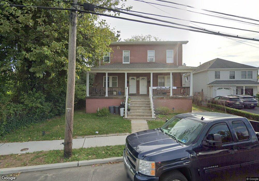
135 Long Branch Ave Long Branch, NJ 07740
Estimated Value: $531,599 - $935,000
4
Beds
2
Baths
1,428
Sq Ft
$535/Sq Ft
Est. Value
About This Home
This home is located at 135 Long Branch Ave, Long Branch, NJ 07740 and is currently estimated at $764,400, approximately $535 per square foot. 135 Long Branch Ave is a home located in Monmouth County with nearby schools including Long Branch High School and Holy Trinity School.
Ownership History
Date
Name
Owned For
Owner Type
Purchase Details
Closed on
Aug 10, 2017
Sold by
Monmouth County Sheriff
Bought by
135 Long Branch Llc
Current Estimated Value
Purchase Details
Closed on
Aug 1, 2005
Sold by
Bianco Jon L
Bought by
Jon L Bianco
Purchase Details
Closed on
Oct 26, 1995
Sold by
Oci Mtg Corp
Bought by
Bianco Devel Corp
Create a Home Valuation Report for This Property
The Home Valuation Report is an in-depth analysis detailing your home's value as well as a comparison with similar homes in the area
Home Values in the Area
Average Home Value in this Area
Purchase History
| Date | Buyer | Sale Price | Title Company |
|---|---|---|---|
| 135 Long Branch Llc | $250,000 | -- | |
| Jon L Bianco | -- | -- | |
| Bianco Devel Corp | $40,000 | -- |
Source: Public Records
Tax History Compared to Growth
Tax History
| Year | Tax Paid | Tax Assessment Tax Assessment Total Assessment is a certain percentage of the fair market value that is determined by local assessors to be the total taxable value of land and additions on the property. | Land | Improvement |
|---|---|---|---|---|
| 2025 | $8,649 | $637,800 | $299,600 | $338,200 |
| 2024 | $7,986 | $562,700 | $254,600 | $308,100 |
| 2023 | $7,986 | $514,200 | $244,600 | $269,600 |
| 2022 | $7,088 | $451,000 | $224,600 | $226,400 |
| 2021 | $7,088 | $354,800 | $143,200 | $211,600 |
| 2020 | $8,193 | $392,000 | $121,200 | $270,800 |
| 2019 | $7,809 | $371,500 | $113,200 | $258,300 |
| 2018 | $7,399 | $350,000 | $101,200 | $248,800 |
| 2017 | $6,950 | $337,200 | $93,200 | $244,000 |
| 2016 | $6,687 | $330,900 | $93,200 | $237,700 |
| 2015 | $7,060 | $317,000 | $61,800 | $255,200 |
| 2014 | $6,434 | $304,500 | $78,000 | $226,500 |
Source: Public Records
Map
Nearby Homes
- 18 Seaview Ave
- 40 Seaview Ave Unit A
- 56 Seaview Ave
- 78 Ocean Terrace
- 33 Cooper Ave Unit 213
- 33 Cooper Ave Unit 410
- 231 Long Branch Ave
- 200 Ocean Ave N Unit 19
- 22 Cooper Ave Unit 113
- 22 Cooper Ave Unit 309
- 22 Cooper Ave Unit 110
- 179 Joline Ave
- 40 University Dr
- 138 Rosewood Ave
- 422 Ocean Blvd N Unit 5H
- 172 Chelton Ave
- 432 Ocean Blvd Unit 208
- 188 Chelton Ave
- 432 Ocean Blvd N Unit 118
- 432 Ocean Blvd N Unit 506
- 133 Long Branch Ave
- 143 Long Branch Ave
- 115 Long Branch Ave
- 111 Long Branch Ave
- 138 Seaview Ave
- 136 Seaview Ave
- 109 Long Branch Ave
- 144 Long Branch Ave
- 134 Seaview Ave
- 107 Long Branch Ave
- 144 Seaview Ave
- 132 Seaview Ave
- 130 Seaview Ave
- 150 Long Branch Ave
- 128 Seaview Ave
- 101 Long Branch Ave
- 152 Long Branch Ave Unit 3
- 152 Long Branch Ave
- 152 Long Branch Ave Unit 1
- 152 Long Branch Ave Unit 4