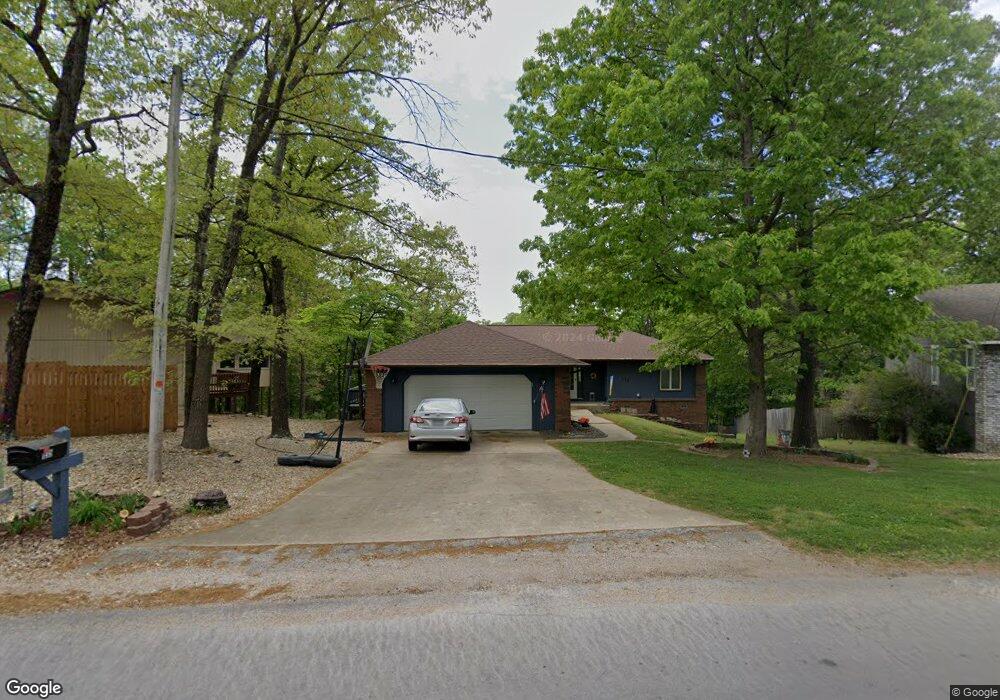
135 Mayfair Dr Bella Vista, AR 72715
Estimated Value: $300,000 - $334,000
3
Beds
2
Baths
1,853
Sq Ft
$170/Sq Ft
Est. Value
About This Home
This home is located at 135 Mayfair Dr, Bella Vista, AR 72715 and is currently estimated at $315,524, approximately $170 per square foot. 135 Mayfair Dr is a home located in Benton County with nearby schools including Cooper Elementary School, Old High Middle School, and Washington Junior High School.
Ownership History
Date
Name
Owned For
Owner Type
Purchase Details
Closed on
Jul 11, 2003
Bought by
Winters
Current Estimated Value
Purchase Details
Closed on
Sep 24, 2001
Bought by
Mckasson
Purchase Details
Closed on
May 13, 1994
Bought by
Bundy
Purchase Details
Closed on
Mar 4, 1991
Bought by
Mcquary
Purchase Details
Closed on
Aug 4, 1989
Bought by
Mcquary
Purchase Details
Closed on
Jan 27, 1989
Bought by
Hendricks
Create a Home Valuation Report for This Property
The Home Valuation Report is an in-depth analysis detailing your home's value as well as a comparison with similar homes in the area
Home Values in the Area
Average Home Value in this Area
Purchase History
| Date | Buyer | Sale Price | Title Company |
|---|---|---|---|
| Winters | $135,000 | -- | |
| Mckasson | $128,000 | -- | |
| Bundy | $94,000 | -- | |
| Mcquary | -- | -- | |
| Mcquary | $86,000 | -- | |
| Hendricks | $5,000 | -- |
Source: Public Records
Tax History Compared to Growth
Tax History
| Year | Tax Paid | Tax Assessment Tax Assessment Total Assessment is a certain percentage of the fair market value that is determined by local assessors to be the total taxable value of land and additions on the property. | Land | Improvement |
|---|---|---|---|---|
| 2025 | $1,505 | $56,079 | $1,600 | $54,479 |
| 2024 | $1,490 | $56,079 | $1,600 | $54,479 |
| 2023 | $1,490 | $36,500 | $800 | $35,700 |
| 2022 | $1,162 | $36,500 | $800 | $35,700 |
| 2021 | $1,159 | $36,500 | $800 | $35,700 |
| 2020 | $1,173 | $24,810 | $600 | $24,210 |
| 2019 | $1,173 | $24,810 | $600 | $24,210 |
| 2018 | $1,198 | $24,810 | $600 | $24,210 |
| 2017 | $1,171 | $24,810 | $600 | $24,210 |
| 2016 | $1,171 | $24,810 | $600 | $24,210 |
| 2015 | $1,465 | $24,300 | $1,000 | $23,300 |
| 2014 | $1,115 | $24,300 | $1,000 | $23,300 |
Source: Public Records
Map
Nearby Homes
- Lot 14 of Block 4 Heather Cir
- 18 Worstead Ln
- Lot 9 Clive Ln
- 1 Thetford Dr
- 55 Portsmouth Dr
- 30 Cromer Dr
- Lot 17 Block 1 Oak Knoll Ln
- 17 Burnham Dr
- 4 Frensham Ln
- 26 Cromer Dr
- 2 Wreston Ln
- 6 Neffwood Ln
- 0 Portsmouth Dr Unit 1319021
- 53 Pimlico Dr
- Lot 5 Neffwood Ln
- 0 Porlock Ln
- TBD Porlock Ln
- Lot 3 of Block 1 Ryde Ln
- Lot 4 of Block 1 Ryde Ln
- 71 Wandsworth Dr