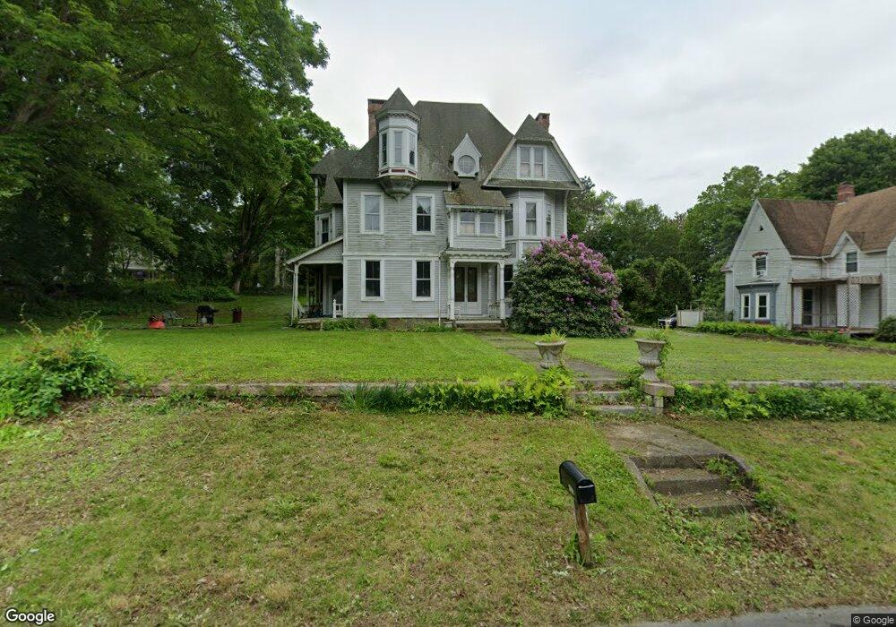
135 Route 2a Preston, CT 06365
Estimated Value: $390,000 - $582,000
6
Beds
2
Baths
3,878
Sq Ft
$123/Sq Ft
Est. Value
About This Home
This home is located at 135 Route 2a, Preston, CT 06365 and is currently estimated at $476,705, approximately $122 per square foot. 135 Route 2a is a home located in New London County with nearby schools including Integrated Day Charter School and St. Joseph School.
Ownership History
Date
Name
Owned For
Owner Type
Purchase Details
Closed on
Sep 1, 2017
Sold by
Coleman Carol A
Bought by
Coleman David
Current Estimated Value
Purchase Details
Closed on
Dec 12, 2000
Sold by
Bank United
Bought by
Coleman Carol Ann and Coleman David
Home Financials for this Owner
Home Financials are based on the most recent Mortgage that was taken out on this home.
Original Mortgage
$148,800
Interest Rate
7.64%
Purchase Details
Closed on
May 25, 1993
Sold by
Fermanis Michael and Fermanis Arlean
Bought by
Benham Justin T and Benham Christine
Home Financials for this Owner
Home Financials are based on the most recent Mortgage that was taken out on this home.
Original Mortgage
$162,000
Interest Rate
6%
Mortgage Type
Unknown
Create a Home Valuation Report for This Property
The Home Valuation Report is an in-depth analysis detailing your home's value as well as a comparison with similar homes in the area
Home Values in the Area
Average Home Value in this Area
Purchase History
| Date | Buyer | Sale Price | Title Company |
|---|---|---|---|
| Coleman David | -- | -- | |
| Coleman Carol Ann | $165,375 | -- | |
| Benham Justin T | $161,000 | -- |
Source: Public Records
Mortgage History
| Date | Status | Borrower | Loan Amount |
|---|---|---|---|
| Previous Owner | Benham Justin T | $50,000 | |
| Previous Owner | Benham Justin T | $147,000 | |
| Previous Owner | Benham Justin T | $148,800 | |
| Previous Owner | Benham Justin T | $162,000 |
Source: Public Records
Tax History Compared to Growth
Tax History
| Year | Tax Paid | Tax Assessment Tax Assessment Total Assessment is a certain percentage of the fair market value that is determined by local assessors to be the total taxable value of land and additions on the property. | Land | Improvement |
|---|---|---|---|---|
| 2025 | $7,801 | $310,660 | $44,450 | $266,210 |
| 2024 | $7,260 | $310,660 | $44,450 | $266,210 |
| 2023 | $7,130 | $310,660 | $44,450 | $266,210 |
| 2022 | $5,780 | $207,300 | $36,300 | $171,000 |
| 2021 | $5,585 | $207,300 | $36,300 | $171,000 |
| 2020 | $5,576 | $207,300 | $36,300 | $171,000 |
| 2019 | $5,479 | $207,300 | $36,300 | $171,000 |
| 2018 | $5,396 | $207,300 | $36,300 | $171,000 |
| 2017 | $4,990 | $207,900 | $37,500 | $170,400 |
| 2016 | $4,938 | $207,900 | $37,500 | $170,400 |
| 2015 | $4,782 | $207,900 | $37,500 | $170,400 |
| 2014 | $4,811 | $207,900 | $37,500 | $170,400 |
Source: Public Records
Map
Nearby Homes
- 5 Arrowhead Dr
- 104 Route 2a
- 7 Barn Rd
- 6 Route 117
- 178 Route 2a
- 11 Willow Ln
- 59 Harris Fuller Rd
- 3 Webster Dr
- 15 Paster Rd
- 18 Maynard Hill Rd
- 3 Holdsworth Rd
- 16 Marlene Dr
- 15 Drawbridge Rd
- 5 Bittersweet Dr
- 34 Ridgewood Dr
- 552 Laurel Hill Rd
- 5 Mount Laurel Rd
- 39 Doolittle Rd
- 547 Old Laurel Hill Rd
- 50 N Glenwoods Rd
- 131 Route 2a
- 134 2a Route
- 134 Rt2a Route
- 138 Route 2a
- 129 Route 2a
- 136 Route 2a
- 9 Shingle Point Rd
- 134 Route 2a
- 13 Shingle Point Rd
- 5 Shingle Point Rd
- 132 Route 2a
- 140 Route 2a
- 125 Route 2a
- 125 Route 2a Unit cottage - unit 2
- 130 Route 2a
- 127 Route 2a
- 1 Shingle Point Rd
- 126 Route 2a
- 142 Connecticut 2a
- 143 Route 2a