
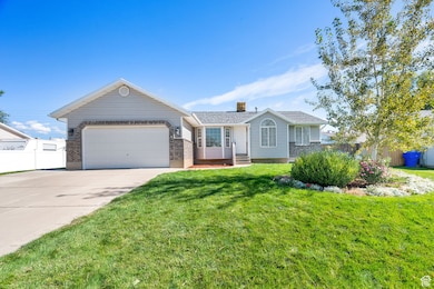
135 S 1525 W Clearfield, UT 84015
Estimated payment $2,709/month
Highlights
- Rambler Architecture
- 2 Car Attached Garage
- Landscaped
- No HOA
- Tile Flooring
- Forced Air Heating and Cooling System
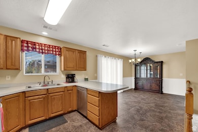
About This Home
Welcome to this charming rambler nestled in the heart of West Point. This single family home offers comfortable single level living with a bright and open floor plan perfect for relaxing and entertaining. This home has been well maintained and cared for. The well maintained yard provides plenty of space for outdoor enjoyment, while being conveniently located close to shopping, schools, churches, and recreation. Whether you're enjoying nearby parks or local amenities, this home combines small town comfort with easy access to everything you need.
Home Details
Home Type
- Single Family
Est. Annual Taxes
- $2,472
Year Built
- Built in 1997
Lot Details
- 9,148 Sq Ft Lot
- Lot Dimensions are 86.0x106.0x86.0
- Partially Fenced Property
- Landscaped
- Sprinkler System
- Property is zoned Single-Family
Parking
- 2 Car Attached Garage
- 4 Open Parking Spaces
Home Design
- Rambler Architecture
- Brick Exterior Construction
Interior Spaces
- 2,678 Sq Ft Home
- 2-Story Property
- Blinds
- Basement Fills Entire Space Under The House
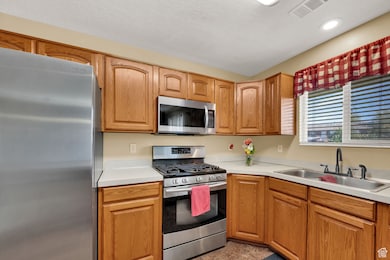
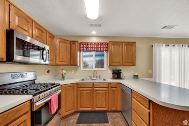
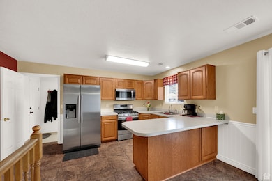
Kitchen
- Free-Standing Range
- Disposal
Flooring
- Carpet
- Linoleum
- Tile
Bedrooms and Bathrooms
- 3 Main Level Bedrooms
- 2 Full Bathrooms
Laundry
- Dryer
- Washer
Schools
- Lakeside Elementary School
- West Point Middle School
- Syracuse High School
Utilities
- Forced Air Heating and Cooling System
- Natural Gas Connected
Community Details
- No Home Owners Association
- Oakcrest Estates Subdivision
Listing and Financial Details
- Assessor Parcel Number 12-237-0108
Map
Home Values in the Area
Average Home Value in this Area
Tax History
| Year | Tax Paid | Tax Assessment Tax Assessment Total Assessment is a certain percentage of the fair market value that is determined by local assessors to be the total taxable value of land and additions on the property. | Land | Improvement |
|---|---|---|---|---|
| 2025 | $2,600 | $243,650 | $101,834 | $141,816 |
| 2024 | $2,472 | $232,651 | $91,735 | $140,916 |
| 2023 | $2,293 | $397,000 | $111,129 | $285,871 |
| 2022 | $2,466 | $233,750 | $56,928 | $176,822 |
| 2021 | $2,200 | $312,000 | $92,388 | $219,612 |
| 2020 | $1,923 | $269,000 | $76,978 | $192,022 |
| 2019 | $1,899 | $262,000 | $74,872 | $187,128 |
| 2018 | $1,691 | $230,000 | $76,283 | $153,717 |
| 2016 | $1,501 | $107,415 | $29,454 | $77,961 |
| 2015 | $1,445 | $97,295 | $29,454 | $67,841 |
| 2014 | $102 | $96,830 | $29,454 | $67,376 |
| 2013 | -- | $85,833 | $28,435 | $57,398 |
Property History
| Date | Event | Price | List to Sale | Price per Sq Ft |
|---|---|---|---|---|
| 10/14/2025 10/14/25 | For Sale | $475,000 | -- | $177 / Sq Ft |
Purchase History
| Date | Type | Sale Price | Title Company |
|---|---|---|---|
| Interfamily Deed Transfer | -- | -- | |
| Deed | -- | For Title | |
| Interfamily Deed Transfer | -- | For Title | |
| Warranty Deed | -- | Founders Title Co | |
| Warranty Deed | -- | Bonneville Title Company | |
| Quit Claim Deed | -- | First American Title Co | |
| Warranty Deed | -- | Old Republic Title Co | |
| Warranty Deed | -- | Bonneville Title Company Inc | |
| Warranty Deed | -- | Bonneville Title Company Inc | |
| Warranty Deed | -- | Meridian Title Company |
Mortgage History
| Date | Status | Loan Amount | Loan Type |
|---|---|---|---|
| Open | $140,000 | New Conventional | |
| Previous Owner | $100,000 | New Conventional | |
| Previous Owner | $128,426 | FHA | |
| Previous Owner | $80,000 | No Value Available |
Source: UtahRealEstate.com
MLS Number: 2117487
APN: 12-237-0108
Disclaimer: Certain information contained herein is derived from information provided by parties other than Homes.com. All information provided is deemed reliable, but is not guaranteed to be accurate and should be independently verified.
![]() IDX information is provided exclusively for consumers’ personal, non-commercial use, that it may not be used for any purpose other than to identify prospective properties consumers may be interested in purchasing, and that the data is deemed reliable but is not guaranteed accurate by the MLS. Licensor is only providing the MLS Content and not other sources of data provided in the Product.
IDX information is provided exclusively for consumers’ personal, non-commercial use, that it may not be used for any purpose other than to identify prospective properties consumers may be interested in purchasing, and that the data is deemed reliable but is not guaranteed accurate by the MLS. Licensor is only providing the MLS Content and not other sources of data provided in the Product.
Based on information from the Wasatch Front Regional Multiple Listing Service, Inc.. All data, including all measurements and calculations of area, is obtained from various sources and has not been, and will not be, verified by broker or the MLS. All information should be independently reviewed and verified for accuracy. Properties may or may not be listed by the office/agent presenting the information.
- 1648 W 150 S
- 16 N 1300 W
- 1828 W 75 S
- 47 N 1750 W
- 4284 W 350 S Unit 615
- 4296 W 350 S Unit 614
- 12 N 2000 W Unit 1
- 587 S 1400 W
- 303 N Canterbury Way
- 575 N 1350 W Unit 137
- 423 N 1250 W Unit 118
- 1774 W 400 N
- 417 N 1200 W Unit 84
- 1337 W 550 N Unit 195
- 1350 W 300 N Unit 49
- 1350 W 300 N Unit 38
- 1350 W 300 N Unit 29
- 563 N 1350 W Unit 139
- 1652 W 560 N
- 817 S 1350 W
- 1733 W 300 S
- 1205 W Canterbury Cir
- 101 N 2000 W
- 662 N 1500 W
- 956 S 1525 W Unit ID1250670P
- 777 N 1000 W Unit B
- 514 W 150 S
- 342 N 75 W
- 684 W 800 N
- 652 W 800 N
- 652 W 800 N Unit 90
- 125 S 150 W
- 1262 N 1000 W
- 101 N Main St
- 854 W 1300 N
- 180 S State St
- 1699 W 1700 S
- 1283 W 1700 S
- 1496 N 2150 W
- 444 S State St
