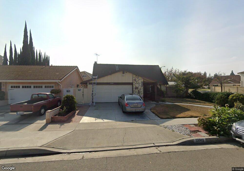
13502 Andy St Cerritos, CA 90703
Estimated Value: $1,031,000 - $1,338,000
3
Beds
3
Baths
2,050
Sq Ft
$593/Sq Ft
Est. Value
About This Home
This home is located at 13502 Andy St, Cerritos, CA 90703 and is currently estimated at $1,216,480, approximately $593 per square foot. 13502 Andy St is a home located in Los Angeles County with nearby schools including Cerritos Elementary School, Carmenita Middle School, and Cerritos High School.
Ownership History
Date
Name
Owned For
Owner Type
Purchase Details
Closed on
Dec 22, 2017
Sold by
Law
Bought by
Law
Current Estimated Value
Home Financials for this Owner
Home Financials are based on the most recent Mortgage that was taken out on this home.
Interest Rate
3.94%
Purchase Details
Closed on
Oct 19, 1993
Sold by
Great Western Bank
Bought by
Law Henry T and Law Janice R
Home Financials for this Owner
Home Financials are based on the most recent Mortgage that was taken out on this home.
Original Mortgage
$186,400
Interest Rate
6.88%
Create a Home Valuation Report for This Property
The Home Valuation Report is an in-depth analysis detailing your home's value as well as a comparison with similar homes in the area
Home Values in the Area
Average Home Value in this Area
Purchase History
We collect this data history from publicly available records. To have your information removed, we recommend requesting removal directly through your county’s website.
| Date | Buyer | Sale Price | Title Company |
|---|---|---|---|
| Law | -- | -- | |
| Law Henry T | $233,000 | Chicago Title Insurance Co |
Source: Public Records
Mortgage History
We collect this data history from publicly available records. To have your information removed, we recommend requesting removal directly through your county’s website.
| Date | Status | Borrower | Loan Amount |
|---|---|---|---|
| Previous Owner | Law | -- | |
| Previous Owner | Law Henry T | $186,400 |
Source: Public Records
Tax History
| Year | Tax Paid | Tax Assessment Tax Assessment Total Assessment is a certain percentage of the fair market value that is determined by local assessors to be the total taxable value of land and additions on the property. | Land | Improvement |
|---|---|---|---|---|
| 2025 | $5,207 | $395,995 | $201,228 | $194,767 |
| 2024 | $4,979 | $388,232 | $197,283 | $190,949 |
| 2023 | $4,822 | $380,620 | $193,415 | $187,205 |
| 2022 | $4,749 | $373,158 | $189,623 | $183,535 |
| 2021 | $4,634 | $365,842 | $185,905 | $179,937 |
| 2019 | $4,529 | $354,992 | $180,392 | $174,600 |
| 2018 | $4,169 | $348,032 | $176,855 | $171,177 |
| 2016 | $3,991 | $334,520 | $169,989 | $164,531 |
| 2015 | $3,941 | $329,496 | $167,436 | $162,060 |
| 2014 | $3,868 | $323,043 | $164,157 | $158,886 |
Source: Public Records
Map
Nearby Homes
- 13508 Caravel Place
- 13613 Edgefield St
- 13618 Edgefield St
- 18420 Heather Ave
- 18520 Linda Cir
- 5372 Bransford Dr
- 17918 Pires Ave
- 19003 Vickie Ave
- 13138 Sutton St
- 13557 Semora Place
- 19008 Jeffrey Ave
- 5374 Houston Ave
- 12947 Arabella Place
- 13130 Rose St
- 17826 Caliente Cir
- 18622 Kamstra Ave
- 5602 Oak Dr
- 5692 Conifer Dr
- 7722 Laurelwood Ln
- 4922 El Rancho Verde Dr
- 13508 Andy St
- 18712 Alexander Cir
- 13512 Andy St
- 13426 Andy St
- 18716 Alexander Cir
- 13501 Andy St
- 13507 Andy St
- 13518 Andy St
- 13433 Andy St
- 13511 Andy St
- 13420 Andy St
- 18713 Alexander Cir
- 18720 Alexander Cir
- 13427 Andy St
- 13517 Andy St
- 13507 Droxford St
- 13524 Andy St
- 18717 Alexander Cir
- 18721 Alexander Cir
- 13503 Droxford St
Your Personal Tour Guide
Ask me questions while you tour the home.