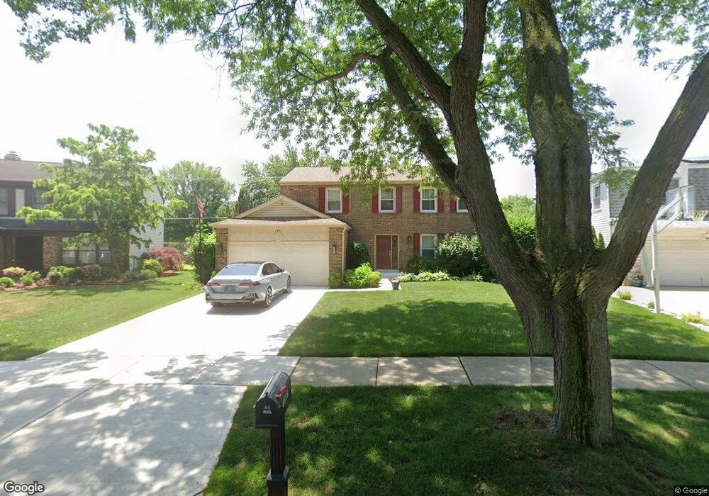
1351 Devonshire Rd Buffalo Grove, IL 60089
Prairie Park-Lake County NeighborhoodEstimated Value: $523,202 - $608,000
Studio
3
Baths
2,199
Sq Ft
$257/Sq Ft
Est. Value
About This Home
This home is located at 1351 Devonshire Rd, Buffalo Grove, IL 60089 and is currently estimated at $565,301, approximately $257 per square foot. 1351 Devonshire Rd is a home located in Lake County with nearby schools including Prairie Elementary School, Twin Groves Middle School, and Adlai E Stevenson High School.
Ownership History
Date
Name
Owned For
Owner Type
Purchase Details
Closed on
Feb 18, 1997
Sold by
Singer Cindy and Singer Cynthia L
Bought by
Factor Ronald B and Factor Sherry L
Current Estimated Value
Home Financials for this Owner
Home Financials are based on the most recent Mortgage that was taken out on this home.
Original Mortgage
$80,000
Interest Rate
7.92%
Purchase Details
Closed on
Jun 15, 1995
Sold by
Singer Kerry H and Singer Cynthia L
Bought by
Singer Kerry H
Create a Home Valuation Report for This Property
The Home Valuation Report is an in-depth analysis detailing your home's value as well as a comparison with similar homes in the area
Home Values in the Area
Average Home Value in this Area
Purchase History
| Date | Buyer | Sale Price | Title Company |
|---|---|---|---|
| Factor Ronald B | $188,500 | Chicago Title Insurance Co | |
| Singer Kerry H | -- | -- |
Source: Public Records
Mortgage History
| Date | Status | Borrower | Loan Amount |
|---|---|---|---|
| Closed | Factor Ronald B | $80,000 |
Source: Public Records
Tax History
| Year | Tax Paid | Tax Assessment Tax Assessment Total Assessment is a certain percentage of the fair market value that is determined by local assessors to be the total taxable value of land and additions on the property. | Land | Improvement |
|---|---|---|---|---|
| 2024 | $13,387 | $155,267 | $28,386 | $126,881 |
| 2023 | $12,943 | $146,506 | $26,784 | $119,722 |
| 2022 | $12,943 | $135,127 | $24,704 | $110,423 |
| 2021 | $12,447 | $133,670 | $24,438 | $109,232 |
| 2020 | $12,155 | $134,126 | $24,521 | $109,605 |
| 2019 | $12,301 | $136,779 | $24,431 | $112,348 |
| 2018 | $11,834 | $135,996 | $24,145 | $111,851 |
| 2017 | $11,692 | $132,821 | $23,581 | $109,240 |
| 2016 | $11,281 | $127,187 | $22,581 | $104,606 |
| 2015 | $10,950 | $118,945 | $21,118 | $97,827 |
| 2014 | $9,671 | $104,958 | $22,681 | $82,277 |
| 2012 | $9,485 | $105,168 | $22,726 | $82,442 |
Source: Public Records
Map
Nearby Homes
- 1152 Courtland Dr Unit 406
- 1234 Devonshire Rd
- 1161 Parker Ln
- 1120 Courtland Dr
- 1265 Devonshire Rd
- 1328 Larchmont Dr
- 1135 Thompson Blvd
- 962 Thompson Blvd
- 1318 Gail Dr Unit 4
- 5107 N Arlington Heights Rd
- 810 Silver Rock Ln
- 1217 Franklin Ln Unit G5
- 327 Lasalle Ln
- 5152 Bridlewood Ln
- 736 Clohesey Dr
- 5176 Aptakisic Rd
- 1602 Brittany Ln
- 711 Woodhollow Ln
- 1005 Cooper Ct
- 5135 Bridlewood Ct
- 1353 Devonshire Rd
- 1349 Devonshire Rd Unit 2
- 1355 Devonshire Rd
- 1347 Devonshire Rd
- 1350 Devonshire Rd
- 1357 Devonshire Rd
- 1345 Devonshire Rd
- 1354 Devonshire Rd
- 1344 Devonshire Rd
- 991 Belmar Ln
- 981 Belmar Ln
- 1356 Devonshire Rd
- 971 Belmar Ln
- 1001 Belmar Ln Unit 11
- 1343 Devonshire Rd
- 1359 Devonshire Rd
- 1342 Devonshire Rd
- 961 Belmar Ln
- 1358 Devonshire Rd
- 1011 Belmar Ln
Your Personal Tour Guide
Ask me questions while you tour the home.