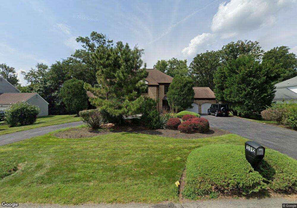
13512 Montvale Dr Silver Spring, MD 20904
Estimated Value: $794,000 - $927,000
4
Beds
3
Baths
3,138
Sq Ft
$268/Sq Ft
Est. Value
About This Home
This home is located at 13512 Montvale Dr, Silver Spring, MD 20904 and is currently estimated at $841,997, approximately $268 per square foot. 13512 Montvale Dr is a home located in Montgomery County with nearby schools including Westover Elementary School, White Oak Middle School, and Springbrook High School.
Ownership History
Date
Name
Owned For
Owner Type
Purchase Details
Closed on
Nov 1, 2011
Sold by
Dicesare Constance B and Dicesare Anthony C
Bought by
Broadus Kevin L and Broadus Belinda J
Current Estimated Value
Home Financials for this Owner
Home Financials are based on the most recent Mortgage that was taken out on this home.
Original Mortgage
$300,000
Outstanding Balance
$203,581
Interest Rate
3.92%
Mortgage Type
New Conventional
Estimated Equity
$638,416
Create a Home Valuation Report for This Property
The Home Valuation Report is an in-depth analysis detailing your home's value as well as a comparison with similar homes in the area
Home Values in the Area
Average Home Value in this Area
Purchase History
| Date | Buyer | Sale Price | Title Company |
|---|---|---|---|
| Broadus Kevin L | $550,000 | None Available |
Source: Public Records
Mortgage History
| Date | Status | Borrower | Loan Amount |
|---|---|---|---|
| Open | Broadus Kevin L | $300,000 |
Source: Public Records
Tax History
| Year | Tax Paid | Tax Assessment Tax Assessment Total Assessment is a certain percentage of the fair market value that is determined by local assessors to be the total taxable value of land and additions on the property. | Land | Improvement |
|---|---|---|---|---|
| 2025 | $7,609 | $655,200 | -- | -- |
| 2024 | $7,609 | $596,300 | $0 | $0 |
| 2023 | $6,205 | $537,400 | $233,900 | $303,500 |
| 2022 | $5,831 | $531,867 | $0 | $0 |
| 2021 | $5,599 | $526,333 | $0 | $0 |
| 2020 | $5,599 | $520,800 | $233,900 | $286,900 |
| 2019 | $5,480 | $512,833 | $0 | $0 |
| 2018 | $5,376 | $504,867 | $0 | $0 |
| 2017 | $5,381 | $496,900 | $0 | $0 |
| 2016 | -- | $488,533 | $0 | $0 |
| 2015 | $6,041 | $480,167 | $0 | $0 |
| 2014 | $6,041 | $471,800 | $0 | $0 |
Source: Public Records
Map
Nearby Homes
- 13524 Sherwood Forest Dr
- 13719 Notley Rd
- 13711 Notley Rd
- 13707 Notley Rd
- 13715 Notley Rd
- 13704 New Hampshire Ave
- 421 Beaumont Rd
- 12916 Shaw Place
- 3 Shannon Ct
- 513 Beaumont Rd
- 216 Paula Lynn Dr
- 604 Hawkesbury Terrace
- 600 Seminole Creek Way
- 609 Seminole Creek Way
- 14212 Notley Rd
- 13137 Broadmore Rd
- 14212 Northwyn Dr
- 605 Rosemere Ave
- 111 Marine Terrace
- 14350 Stilton Cir
- 13516 Montvale Dr
- 13508 Montvale Dr
- 2 Montvale Ct
- 13505 Sherwood Forest Terrace
- 13520 Montvale Dr
- 13504 Montvale Dr
- 13511 Sherwood Forest Terrace
- 13505 Montvale Dr
- 13517 Montvale Dr
- 6 Montvale Ct
- 13524 Montvale Dr
- 51 Beaumont Rd
- 13407 Sherwood Forest Dr
- 205 Montvale Terrace
- 5 Montvale Ct
- 13501 Montvale Dr
- 13401 Sherwood Forest Dr
- 13528 Montvale Dr
- 13512 Sherwood Forest Terrace
- 13532 Montvale Dr
Your Personal Tour Guide
Ask me questions while you tour the home.