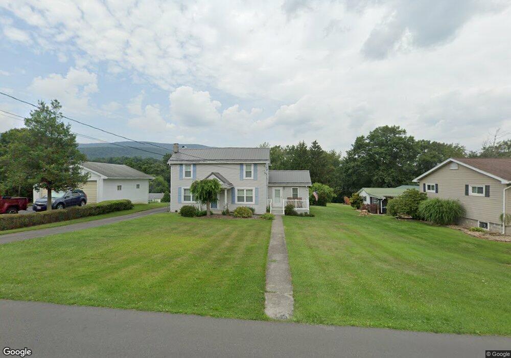
13523 Brant Rd SW Cumberland, MD 21502
Estimated Value: $145,119 - $209,000
--
Bed
1
Bath
1,336
Sq Ft
$130/Sq Ft
Est. Value
About This Home
This home is located at 13523 Brant Rd SW, Cumberland, MD 21502 and is currently estimated at $173,780, approximately $130 per square foot. 13523 Brant Rd SW is a home located in Allegany County with nearby schools including Cresaptown Elementary School, Braddock Middle School, and Allegany High School.
Ownership History
Date
Name
Owned For
Owner Type
Purchase Details
Closed on
Feb 22, 1996
Sold by
Walsh Joseph H
Bought by
Walsh Joseph H and Walsh Sherri L
Current Estimated Value
Purchase Details
Closed on
Sep 2, 1986
Sold by
Walsh Annie Elizabeth
Bought by
Walsh Joseph H
Home Financials for this Owner
Home Financials are based on the most recent Mortgage that was taken out on this home.
Original Mortgage
$22,500
Interest Rate
9.93%
Create a Home Valuation Report for This Property
The Home Valuation Report is an in-depth analysis detailing your home's value as well as a comparison with similar homes in the area
Home Values in the Area
Average Home Value in this Area
Purchase History
| Date | Buyer | Sale Price | Title Company |
|---|---|---|---|
| Walsh Joseph H | -- | -- | |
| Walsh Joseph H | $23,500 | -- |
Source: Public Records
Mortgage History
| Date | Status | Borrower | Loan Amount |
|---|---|---|---|
| Previous Owner | Walsh Joseph H | $22,500 | |
| Closed | Walsh Joseph H | -- |
Source: Public Records
Tax History Compared to Growth
Tax History
| Year | Tax Paid | Tax Assessment Tax Assessment Total Assessment is a certain percentage of the fair market value that is determined by local assessors to be the total taxable value of land and additions on the property. | Land | Improvement |
|---|---|---|---|---|
| 2025 | $1,471 | $131,300 | $27,600 | $103,700 |
| 2024 | $1,566 | $120,133 | $0 | $0 |
| 2023 | $1,112 | $108,967 | $0 | $0 |
| 2022 | $1,435 | $97,800 | $21,600 | $76,200 |
| 2021 | $1,396 | $96,067 | $0 | $0 |
| 2020 | $1,384 | $94,333 | $0 | $0 |
| 2019 | $1,358 | $92,600 | $22,200 | $70,400 |
| 2018 | $1,326 | $90,367 | $0 | $0 |
| 2017 | $1,294 | $88,133 | $0 | $0 |
| 2016 | $0 | $85,900 | $0 | $0 |
| 2015 | -- | $85,900 | $0 | $0 |
| 2014 | -- | $85,900 | $0 | $0 |
Source: Public Records
Map
Nearby Homes
- 14619 Redwood St
- 14620 Redwood St
- 0 Fir Tree Ln Unit MDAL2012106
- 14804 Bell St
- 14801 Connecticut Ave
- 11813 Illinois Ave
- 14716 Howard St
- LOT 127 Howard St
- 14526 Mcmullen Hwy SW
- 14527 Mcmullen Hwy SW
- 0 Oakwood St
- 14129 Louise Dr SW
- 14104 Louise Dr SW
- 14003 Cedarwood Dr SW
- 12706 Darrows Ave
- 14308L Greenfield Crescent SW
- 14200 Stonefield Ln
- 15509 Westwood Rd SW
- 15708 Downing St SW
- 14407 N Bel Air Dr SW
- 13521 Brant Rd SW
- 13603 Brant Rd SW
- 13604 Cecil Ave
- 13515 Brant Rd SW
- 13519 Brant Rd SW
- 13607 Brant Rd SW
- 13605 Cecil Ave
- 13609 Cecil Ave
- 13518 Brant Rd SW
- 13609 Brant Rd SW
- 13516 Brant Rd SW
- 13611 Brant Rd SW
- 13514 Brant Rd SW
- 13517 Brant Rd SW
- 13513 Brant Rd SW
- 14700 Ridgeway Ave
- 13611 Cecil Ave
- 13613 Brant Rd SW
- 13510 Brant Rd SW
- 14802 Hill St