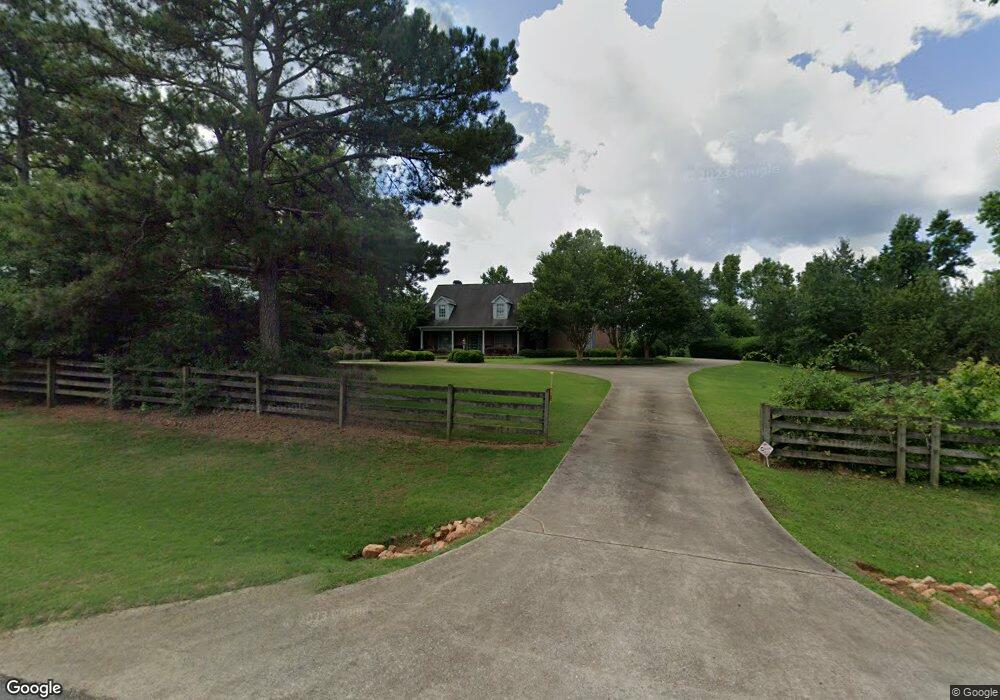
1353 Austin Rd Winder, GA 30680
Estimated Value: $705,000 - $1,597,360
4
Beds
3
Baths
3,239
Sq Ft
$355/Sq Ft
Est. Value
About This Home
This home is located at 1353 Austin Rd, Winder, GA 30680 and is currently estimated at $1,151,180, approximately $355 per square foot. 1353 Austin Rd is a home located in Barrow County with nearby schools including Bethlehem Elementary School, Haymon-Morris Middle School, and Apalachee High School.
Ownership History
Date
Name
Owned For
Owner Type
Purchase Details
Closed on
Mar 10, 2000
Sold by
Lanthier Ludger W
Bought by
Adamson Robert W and Adamson Nancy P
Current Estimated Value
Create a Home Valuation Report for This Property
The Home Valuation Report is an in-depth analysis detailing your home's value as well as a comparison with similar homes in the area
Home Values in the Area
Average Home Value in this Area
Purchase History
| Date | Buyer | Sale Price | Title Company |
|---|---|---|---|
| Adamson Robert W | -- | -- | |
| Adamson Robert W | $714,300 | -- |
Source: Public Records
Tax History Compared to Growth
Tax History
| Year | Tax Paid | Tax Assessment Tax Assessment Total Assessment is a certain percentage of the fair market value that is determined by local assessors to be the total taxable value of land and additions on the property. | Land | Improvement |
|---|---|---|---|---|
| 2024 | $3,705 | $559,949 | $331,275 | $228,674 |
| 2023 | $3,398 | $559,949 | $331,275 | $228,674 |
| 2022 | $2,828 | $482,173 | $331,275 | $150,898 |
| 2021 | $2,718 | $471,848 | $331,275 | $140,573 |
| 2020 | $2,730 | $421,737 | $291,489 | $130,248 |
| 2019 | $2,623 | $421,737 | $291,489 | $130,248 |
| 2018 | $2,694 | $421,737 | $291,489 | $130,248 |
| 2017 | $11,809 | $405,573 | $291,489 | $114,084 |
| 2016 | $2,296 | $353,825 | $244,095 | $109,730 |
| 2015 | $2,561 | $354,744 | $244,095 | $110,649 |
| 2014 | -- | $265,348 | $153,780 | $111,568 |
| 2013 | -- | $259,000 | $153,779 | $105,220 |
Source: Public Records
Map
Nearby Homes
- 296 Westminster Trail
- 131 Wallace Dr
- 101 Westminster Ct
- 1210 Austin Rd
- 140 Westminster Ct
- 1216 Austin Rd
- 264 Westminster Ct
- 258 Westminster Ct
- 0 Manning Gin Rd Unit 10529477
- 0 Manning Gin Rd Unit 7585578
- 1221 Casper Ln
- 1625 Austin Rd
- 159 Mockingbird Ln Unit 16
- 111 Mockingbird Ln Unit 15
- 1301 Palmer Ln
- 199 Mockingbird Ln Unit 17
- 225 Mockingbird Ln Unit 18
- 3300 Jack Glass Rd
- 1330 Perry Sims Rd
- 0 Manning Gin Rd Unit 3112045
- 0 Manning Gin Rd Unit 8032140
- 0 Manning Gin Rd Unit 4263132
- 0 Manning Gin Rd Unit 4308319
- 00 Manning Gin Rd
- 0 Manning Gin Rd Unit CM923644
- 0 Manning Gin Rd Unit 7200789
- 0 Manning Gin Rd Unit 7160170
- 0 Manning Gin Rd Unit 7307191
- 0 Manning Gin Rd Unit 7339495
- 1085 Manning Gin Rd Unit B
- 1085 Manning Gin Rd
- 1356 Perry Sims Rd
- 1014 Manning Gin Rd
- 1344 Perry Sims Rd
- 1139 Manning Gin Rd
- 1334 Perry Sims Rd
- 1329 Austin Rd
- 1147 Manning Gin Rd