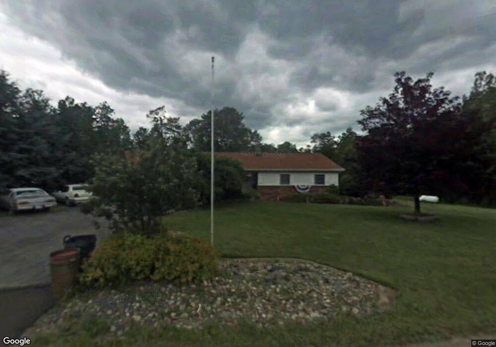
13549 Route 28 Brockway, PA 15824
Estimated Value: $183,000 - $204,153
--
Bed
--
Bath
1,438
Sq Ft
$137/Sq Ft
Est. Value
About This Home
This home is located at 13549 Route 28, Brockway, PA 15824 and is currently estimated at $196,288, approximately $136 per square foot. 13549 Route 28 is a home located in Jefferson County with nearby schools including Brockway Area Elementary School, Brockway Area Junior/Senior High School, and Hillside School.
Ownership History
Date
Name
Owned For
Owner Type
Purchase Details
Closed on
Aug 12, 2022
Sold by
Todd Watt
Bought by
Heibrun Chris Ray and Heilbrun Teresa
Current Estimated Value
Home Financials for this Owner
Home Financials are based on the most recent Mortgage that was taken out on this home.
Original Mortgage
$84,000
Outstanding Balance
$71,172
Interest Rate
4.67%
Mortgage Type
New Conventional
Estimated Equity
$125,116
Purchase Details
Closed on
Apr 14, 2021
Sold by
Donahue Barbara L
Bought by
Watt Todd
Purchase Details
Closed on
Apr 5, 2021
Sold by
Donahue Terry L
Bought by
Donahue Barbara L
Purchase Details
Closed on
May 6, 2015
Sold by
Donahue Terry L and Donahue Barbara L
Bought by
Donahue Terry L
Home Financials for this Owner
Home Financials are based on the most recent Mortgage that was taken out on this home.
Original Mortgage
$74,500
Interest Rate
3.69%
Mortgage Type
New Conventional
Create a Home Valuation Report for This Property
The Home Valuation Report is an in-depth analysis detailing your home's value as well as a comparison with similar homes in the area
Home Values in the Area
Average Home Value in this Area
Purchase History
| Date | Buyer | Sale Price | Title Company |
|---|---|---|---|
| Heibrun Chris Ray | $184,000 | None Listed On Document | |
| Watt Todd | -- | Key Settlement Services Llc | |
| Donahue Barbara L | $90,000 | None Available | |
| Donahue Terry L | -- | None Available |
Source: Public Records
Mortgage History
| Date | Status | Borrower | Loan Amount |
|---|---|---|---|
| Open | Heibrun Chris Ray | $84,000 | |
| Previous Owner | Donahue Terry L | $74,500 |
Source: Public Records
Tax History Compared to Growth
Tax History
| Year | Tax Paid | Tax Assessment Tax Assessment Total Assessment is a certain percentage of the fair market value that is determined by local assessors to be the total taxable value of land and additions on the property. | Land | Improvement |
|---|---|---|---|---|
| 2025 | $1,943 | $50,110 | $5,220 | $44,890 |
| 2024 | $2,278 | $50,110 | $5,220 | $44,890 |
| 2023 | $1,893 | $50,110 | $5,220 | $44,890 |
| 2022 | $1,893 | $50,110 | $5,220 | $44,890 |
| 2021 | $1,893 | $50,110 | $5,220 | $44,890 |
| 2020 | $1,893 | $50,110 | $5,220 | $44,890 |
| 2019 | $1,811 | $50,110 | $5,220 | $44,890 |
| 2018 | $1,764 | $50,110 | $5,220 | $44,890 |
| 2017 | $1,736 | $50,110 | $5,220 | $44,890 |
| 2016 | $1,581 | $50,110 | $5,220 | $44,890 |
| 2015 | -- | $50,110 | $5,220 | $44,890 |
| 2012 | -- | $50,110 | $5,220 | $44,890 |
Source: Public Records
Map
Nearby Homes
- 19 Salandra Ln
- 1074 10th Ave
- 970 Baghdad Rd
- 0 Coal Glen Rd
- 1549 Main St
- 0 U S 219
- 924 Elm St
- 5546 Stevenson Hill Rd
- 7956 U S 219
- 425 Zuccolotto Ln
- 00 Pennsylvania 830
- 1083 Rattlesnake Rd
- 725 Russel Rd
- 5850 U S 219
- 3539 Stevenson Hill Rd
- 559 Buskirk Rd
- 3243 Stevenson Hill Rd
- 101 Howard Rd
- 1032 Beechtree Rd
- 10217 Pennsylvania 28