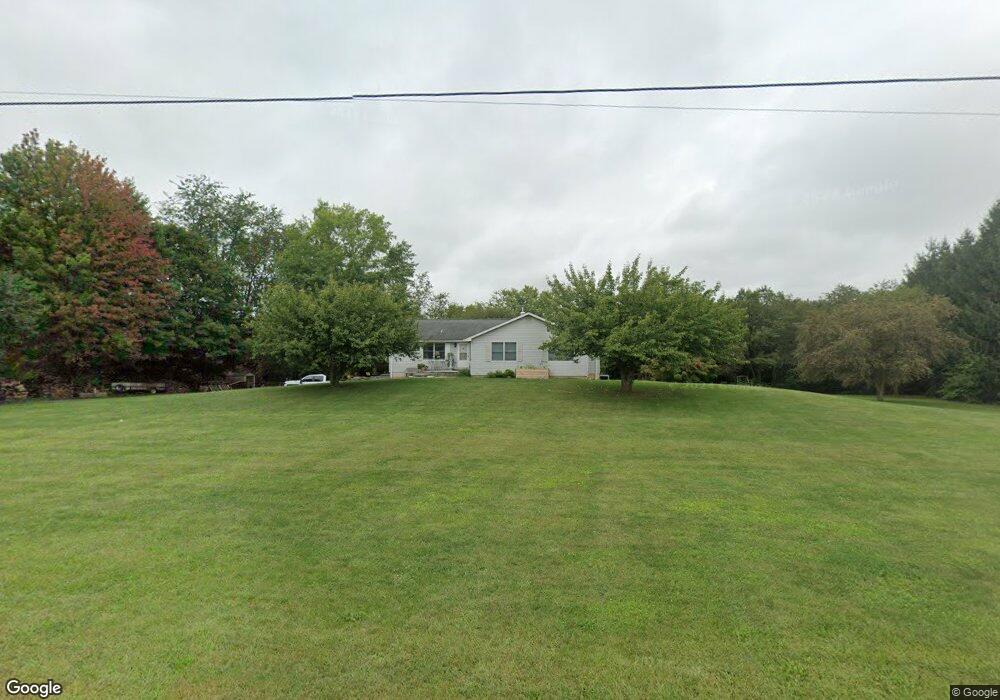
13567 Scott Rd Waynesboro, PA 17268
Estimated Value: $208,333 - $445,000
--
Bed
1
Bath
1,932
Sq Ft
$180/Sq Ft
Est. Value
About This Home
This home is located at 13567 Scott Rd, Waynesboro, PA 17268 and is currently estimated at $347,583, approximately $179 per square foot. 13567 Scott Rd is a home located in Franklin County with nearby schools including Waynesboro Area Senior High School, CITY LIGHT SCHOOL, and Shady Grove Mennonite School.
Ownership History
Date
Name
Owned For
Owner Type
Purchase Details
Closed on
Jun 6, 2006
Sold by
Walz Jesse James and Walz Janie L
Bought by
Mccann William C and Mccann Dawn
Current Estimated Value
Home Financials for this Owner
Home Financials are based on the most recent Mortgage that was taken out on this home.
Original Mortgage
$304,700
Outstanding Balance
$179,439
Interest Rate
6.6%
Mortgage Type
VA
Estimated Equity
$168,144
Purchase Details
Closed on
May 16, 2005
Sold by
Hill Ronald W
Bought by
Walz Jesse James and Walz Janie L
Home Financials for this Owner
Home Financials are based on the most recent Mortgage that was taken out on this home.
Original Mortgage
$53,980
Interest Rate
5.95%
Mortgage Type
Purchase Money Mortgage
Create a Home Valuation Report for This Property
The Home Valuation Report is an in-depth analysis detailing your home's value as well as a comparison with similar homes in the area
Home Values in the Area
Average Home Value in this Area
Purchase History
| Date | Buyer | Sale Price | Title Company |
|---|---|---|---|
| Mccann William C | $295,000 | None Available | |
| Walz Jesse James | $569,900 | None Available |
Source: Public Records
Mortgage History
| Date | Status | Borrower | Loan Amount |
|---|---|---|---|
| Open | Mccann William C | $304,700 | |
| Previous Owner | Walz Jesse James | $53,980 |
Source: Public Records
Tax History Compared to Growth
Tax History
| Year | Tax Paid | Tax Assessment Tax Assessment Total Assessment is a certain percentage of the fair market value that is determined by local assessors to be the total taxable value of land and additions on the property. | Land | Improvement |
|---|---|---|---|---|
| 2025 | $4,144 | $26,980 | $5,780 | $21,200 |
| 2024 | $4,023 | $26,980 | $5,780 | $21,200 |
| 2023 | $3,781 | $26,130 | $5,780 | $20,350 |
| 2022 | $3,669 | $26,130 | $5,780 | $20,350 |
| 2021 | $3,565 | $26,130 | $5,780 | $20,350 |
| 2020 | $3,510 | $26,130 | $5,780 | $20,350 |
| 2019 | $3,431 | $26,130 | $5,780 | $20,350 |
| 2018 | $3,320 | $26,130 | $5,780 | $20,350 |
| 2017 | $3,248 | $26,130 | $5,780 | $20,350 |
| 2016 | $749 | $26,130 | $5,780 | $20,350 |
| 2015 | $698 | $26,130 | $5,780 | $20,350 |
| 2014 | $698 | $26,130 | $5,780 | $20,350 |
Source: Public Records
Map
Nearby Homes
- 4594 Salem Church Rd
- 4798 Gray Hawk Dr Unit 17
- 12152 Red Hawk Dr
- 15365 Wingerton Rd
- 12041 Koons Rd
- 5377 Harrier Way
- TBD Whippet Trail
- 5385 Harrier Way
- TBD Harrier Way
- 6287 Marsh Rd
- 12093 Gearhart Rd
- 6668 Marsh Rd
- 462 Scott Ave Unit 4
- 607 Chicory Spring Ct
- 911 Park St
- 417 Fairview Ave
- 14287 Ridge Rd
- 511 Hamilton Ave
- 305 W 7th St