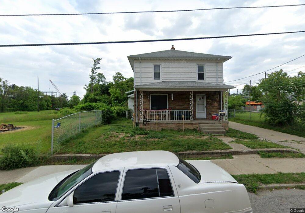
1357 Bennett Ave Flint, MI 48506
Eastside NeighborhoodEstimated Value: $53,000 - $72,000
4
Beds
2
Baths
1,406
Sq Ft
$45/Sq Ft
Est. Value
About This Home
This home is located at 1357 Bennett Ave, Flint, MI 48506 and is currently estimated at $63,350, approximately $45 per square foot. 1357 Bennett Ave is a home located in Genesee County with nearby schools including Potter School, Flint Cultural Center Academy, and WAY Academy of Flint.
Ownership History
Date
Name
Owned For
Owner Type
Purchase Details
Closed on
May 2, 2008
Sold by
Wamsley Doris O and Parker Timothy J
Bought by
Wamsley Doris O and Parker Thomas C
Current Estimated Value
Purchase Details
Closed on
Jul 2, 2001
Sold by
Wamsley Doris
Bought by
Wamsley Doris and Parker Timothy J
Purchase Details
Closed on
Oct 4, 2000
Sold by
Bender William C
Bought by
Wamsley Doris O
Create a Home Valuation Report for This Property
The Home Valuation Report is an in-depth analysis detailing your home's value as well as a comparison with similar homes in the area
Home Values in the Area
Average Home Value in this Area
Purchase History
| Date | Buyer | Sale Price | Title Company |
|---|---|---|---|
| Wamsley Doris O | -- | None Available | |
| Wamsley Doris | -- | -- | |
| Wamsley Doris O | $1,500 | Sargents Abstract & Title Co |
Source: Public Records
Tax History Compared to Growth
Tax History
| Year | Tax Paid | Tax Assessment Tax Assessment Total Assessment is a certain percentage of the fair market value that is determined by local assessors to be the total taxable value of land and additions on the property. | Land | Improvement |
|---|---|---|---|---|
| 2025 | $662 | $19,800 | $0 | $0 |
| 2024 | $624 | $19,200 | $0 | $0 |
| 2023 | $619 | $16,000 | $0 | $0 |
| 2022 | $0 | $12,900 | $0 | $0 |
| 2021 | $1,108 | $11,600 | $0 | $0 |
| 2020 | $583 | $13,200 | $0 | $0 |
| 2019 | $579 | $12,600 | $0 | $0 |
| 2018 | $544 | $14,000 | $0 | $0 |
| 2017 | $533 | $0 | $0 | $0 |
| 2016 | $530 | $0 | $0 | $0 |
| 2015 | -- | $0 | $0 | $0 |
| 2014 | -- | $0 | $0 | $0 |
Source: Public Records
Map
Nearby Homes
- 1215 Bennett Ave
- 1513 Jane Ave
- 1273 Broadway Blvd
- 1529 Broadway Blvd
- 1449 New York Ave
- 1454 Delaware Ave
- 1622 New York Ave
- 1445 Maryland Ave
- 1629 New York Ave
- 1379 Washington Ave
- 1805 Bennett Ave
- 1814 Mabel Ave
- 1721 New York Ave
- 1518 Leith St
- 1526 Montana Ave
- 1644 Pennsylvania Ave
- 2225 Arlington Ave
- 1733 Oklahoma Ave
- 1623 Montana Ave
- 2506 Arlington Ave
- 1354 Mabel Ave
- 1350 Mabel Ave
- 1346 Mabel Ave
- 1410 Mabel Ave
- 2212 Lewis St
- 2218 Lewis St
- 1413 Bennett Ave
- 1405 Bennett Ave
- 1347 Mabel Ave
- 1401 Mabel Ave
- 1341 Mabel Ave
- 1337 Mabel Ave
- 1333 Mabel Ave
- 1413 E Hamilton Ave
- 2311 Lewis St
- 1422 Bennett Ave
- 1422 Mabel Ave
- 1409 Mabel Ave
- 1409 E Hamilton Ave
- 1418 Mabel Ave