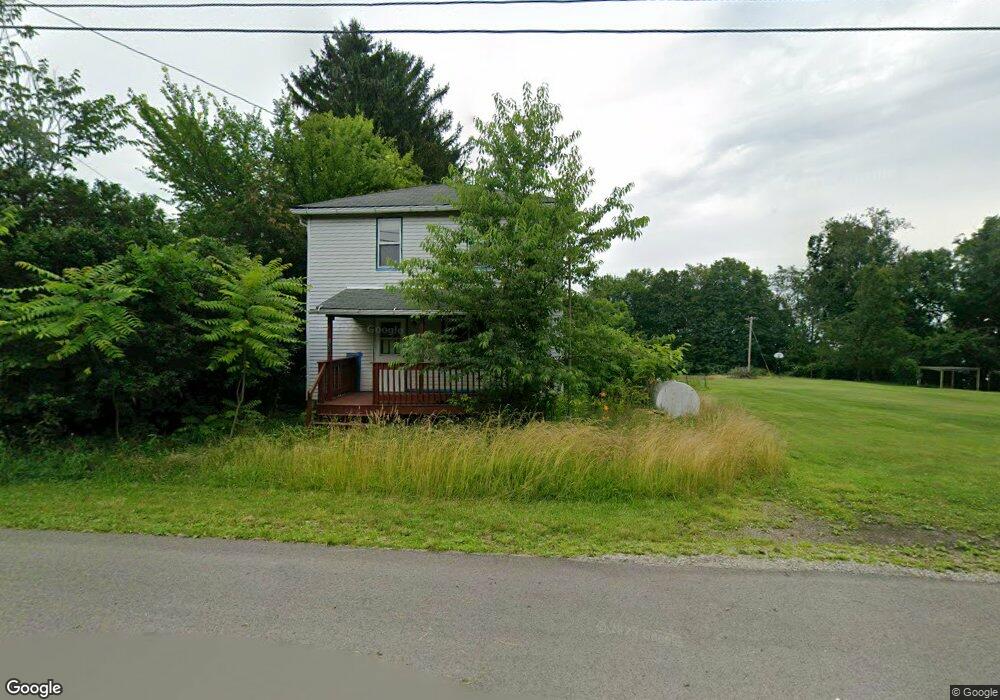
1359 Brownstown Rd Apollo, PA 15613
Kiskiminetas Township NeighborhoodEstimated Value: $76,000 - $187,000
3
Beds
1
Bath
1,186
Sq Ft
$100/Sq Ft
Est. Value
About This Home
This home is located at 1359 Brownstown Rd, Apollo, PA 15613 and is currently estimated at $118,263, approximately $99 per square foot. 1359 Brownstown Rd is a home located in Armstrong County with nearby schools including Apollo-Ridge Elementary School, Apollo-Ridge Middle School, and Apollo-Ridge High School.
Ownership History
Date
Name
Owned For
Owner Type
Purchase Details
Closed on
Mar 5, 2024
Sold by
Miller Andrew J
Bought by
Shaffer Kyle
Current Estimated Value
Purchase Details
Closed on
Mar 23, 2023
Sold by
Zerfoss Property Llc
Bought by
Miller Andrew J
Purchase Details
Closed on
Jun 13, 2022
Sold by
Tax Claim Bureau Of Armstrong County Pen
Bought by
Zerfoss Property Llc
Purchase Details
Closed on
May 10, 2013
Sold by
Reedy Ruby J
Bought by
Montgomery John M
Create a Home Valuation Report for This Property
The Home Valuation Report is an in-depth analysis detailing your home's value as well as a comparison with similar homes in the area
Home Values in the Area
Average Home Value in this Area
Purchase History
| Date | Buyer | Sale Price | Title Company |
|---|---|---|---|
| Shaffer Kyle | $9,500 | Keymax Settlement Services | |
| Miller Andrew J | $15,000 | Ciamacco Settlement Services | |
| Zerfoss Property Llc | $2,314 | None Listed On Document | |
| Montgomery John M | -- | None Available |
Source: Public Records
Tax History Compared to Growth
Tax History
| Year | Tax Paid | Tax Assessment Tax Assessment Total Assessment is a certain percentage of the fair market value that is determined by local assessors to be the total taxable value of land and additions on the property. | Land | Improvement |
|---|---|---|---|---|
| 2025 | $1,388 | $14,500 | $8,580 | $5,920 |
| 2024 | $1,289 | $14,500 | $8,580 | $5,920 |
| 2023 | $1,084 | $14,500 | $8,580 | $5,920 |
| 2022 | $1,072 | $14,500 | $8,580 | $5,920 |
| 2021 | $1,053 | $14,500 | $8,580 | $5,920 |
| 2020 | $1,053 | $14,500 | $8,580 | $5,920 |
| 2019 | $1,047 | $14,500 | $8,580 | $5,920 |
| 2018 | $1,047 | $12,260 | $3,800 | $8,460 |
| 2017 | $1,041 | $14,500 | $8,580 | $5,920 |
| 2016 | $1,041 | $14,500 | $8,580 | $5,920 |
| 2015 | -- | $14,500 | $8,580 | $5,920 |
| 2014 | -- | $14,500 | $8,580 | $5,920 |
Source: Public Records
Map
Nearby Homes
- Lot 10 Beulah Church Rd
- Lot 6 Horrell Rd
- Lot A Guthrie Rd
- 4416 State Route 819
- 140 High St
- 107 High St
- 107 Moglia Ln
- 115 Truxall Rd
- 4765 Pennsylvania 981
- 225 Kochka Dr
- 309 Whitesell St
- 957 Cherry Lane Rd
- 438 Weister Ln
- 718 Route 356
- 311 & 313 N 2nd St
- 1239 Old State Rd
- 527 Westmoreland Ave
- 604 Patterson Rd
- 149 Florida Ave
- 625 Rose St Unit 276
- 1363 Brownstown Rd
- 1367 Brownstown Rd
- 1349 Brownstown Rd
- 1373 Brownstown Rd
- 1364 Brownstown Rd
- 1352 Brownstown Rd
- 1368 Brownstown Rd
- 1343 Brownstown Rd
- 1372 Brownstown Rd
- 1372 Brownstown Rd
- 1376 Brownstown Rd
- 1425 2nd St
- 1280 Main St
- 1429 2nd St
- 1325 Brownstown Rd
- 1325 Brownstown Rd
- 1275 Main St
- 1433 2nd St
- 1319 Brownstown Rd
- 1437 2nd St