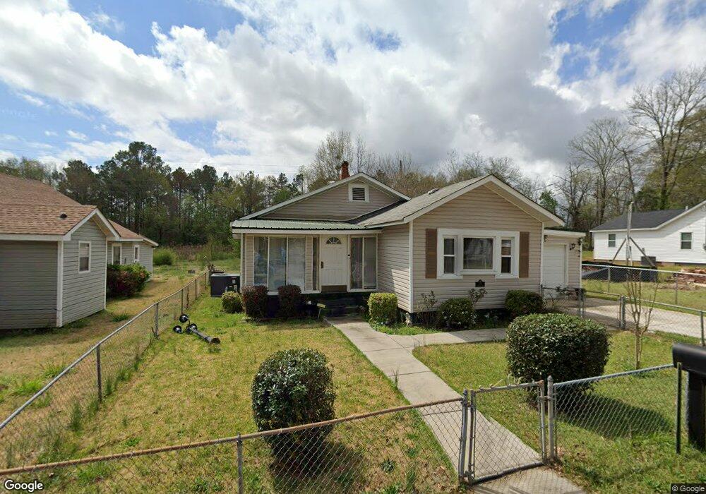
136 Auburn Ave Lagrange, GA 30241
Estimated Value: $157,608 - $189,000
3
Beds
2
Baths
1,776
Sq Ft
$96/Sq Ft
Est. Value
About This Home
This home is located at 136 Auburn Ave, Lagrange, GA 30241 and is currently estimated at $171,152, approximately $96 per square foot. 136 Auburn Ave is a home located in Troup County with nearby schools including Whitesville Road Elementary School, Berta Weathersbee Elementary School, and Rosemont Elementary School.
Ownership History
Date
Name
Owned For
Owner Type
Purchase Details
Closed on
Jun 11, 1998
Sold by
Curtis Williams
Bought by
Leslie Carol
Current Estimated Value
Purchase Details
Closed on
Jan 22, 1998
Sold by
Carol Leslie
Bought by
Curtis Williams
Purchase Details
Closed on
Oct 1, 1987
Sold by
Carol Willis and Carol Leslie
Bought by
Carol Leslie
Purchase Details
Closed on
Mar 1, 1974
Sold by
Bass
Bought by
Carol Willis and Carol Leslie
Purchase Details
Closed on
May 1, 1967
Sold by
Cantrell
Bought by
Bass
Create a Home Valuation Report for This Property
The Home Valuation Report is an in-depth analysis detailing your home's value as well as a comparison with similar homes in the area
Home Values in the Area
Average Home Value in this Area
Purchase History
| Date | Buyer | Sale Price | Title Company |
|---|---|---|---|
| Leslie Carol | -- | -- | |
| Curtis Williams | -- | -- | |
| Carol Leslie | -- | -- | |
| Carol Willis | $9,000 | -- | |
| Bass | -- | -- |
Source: Public Records
Tax History Compared to Growth
Tax History
| Year | Tax Paid | Tax Assessment Tax Assessment Total Assessment is a certain percentage of the fair market value that is determined by local assessors to be the total taxable value of land and additions on the property. | Land | Improvement |
|---|---|---|---|---|
| 2024 | $498 | $45,156 | $3,280 | $41,876 |
| 2023 | $142 | $36,076 | $3,280 | $32,796 |
| 2022 | $660 | $25,636 | $3,280 | $22,356 |
| 2021 | $385 | $14,740 | $1,640 | $13,100 |
| 2020 | $385 | $14,740 | $1,640 | $13,100 |
| 2019 | $348 | $13,536 | $1,640 | $11,896 |
| 2018 | $348 | $13,536 | $1,640 | $11,896 |
| 2017 | $348 | $13,536 | $1,640 | $11,896 |
| 2016 | $341 | $13,302 | $1,650 | $11,652 |
| 2015 | $342 | $13,302 | $1,650 | $11,652 |
| 2014 | $345 | $13,373 | $1,650 | $11,723 |
| 2013 | -- | $13,373 | $1,650 | $11,723 |
Source: Public Records
Map
Nearby Homes
- 0 Lanett Ave
- 213 Euclid Ave
- 216 Euclid Ave
- 0 Hamilton Rd Unit 10577713
- 1315 Hamilton Rd
- 1216 Hamilton Rd
- 130 Edgewood Ave
- 137 Edgewood Ave
- LOT 15 Edgewood Ave
- LOT 33 E Hillside Dr
- LOT 34 E Hillside Dr
- 1404 Hamilton Rd
- 114 Brenda Blvd
- 304 Butler St
- 0 Boggs St Unit 10550243
- 0 Boggs St Unit 10550231
- 0 Boggs St Unit 10550239
- 0 Boggs St Unit 10550250
- 901 Whiteline St
- 0 Bagley St