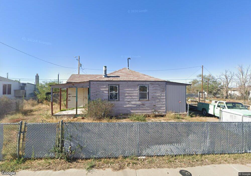
136 Cedar Rd East Carbon, UT 84520
Estimated Value: $122,000 - $163,000
2
Beds
1
Bath
692
Sq Ft
$195/Sq Ft
Est. Value
About This Home
This home is located at 136 Cedar Rd, East Carbon, UT 84520 and is currently estimated at $134,723, approximately $194 per square foot. 136 Cedar Rd is a home located in Carbon County with nearby schools including Wellington School, Mont Harmon Junior High School, and Carbon High School.
Ownership History
Date
Name
Owned For
Owner Type
Purchase Details
Closed on
Jan 23, 2018
Sold by
Roennebeck Myrna
Bought by
Mountford Steven
Current Estimated Value
Purchase Details
Closed on
Oct 23, 2017
Sold by
Ross Tamra
Bought by
Roennebeck Myrna and Roennebeck Family Living Trust
Purchase Details
Closed on
Sep 30, 2009
Sold by
Porter Garland and Porter Colleen
Bought by
Roennebeck Carl Fredrick W and Roennebeck Myrna C
Create a Home Valuation Report for This Property
The Home Valuation Report is an in-depth analysis detailing your home's value as well as a comparison with similar homes in the area
Home Values in the Area
Average Home Value in this Area
Purchase History
| Date | Buyer | Sale Price | Title Company |
|---|---|---|---|
| Mountford Steven | -- | South Eastern Utah Title Co | |
| Roennebeck Myrna | $17,106 | South Eastern Utah Title Co | |
| Roennebeck Carl Fredrick W | -- | South Eastern Utah Title Com |
Source: Public Records
Tax History Compared to Growth
Tax History
| Year | Tax Paid | Tax Assessment Tax Assessment Total Assessment is a certain percentage of the fair market value that is determined by local assessors to be the total taxable value of land and additions on the property. | Land | Improvement |
|---|---|---|---|---|
| 2024 | $651 | $37,075 | $9,488 | $27,587 |
| 2023 | $465 | $29,005 | $3,764 | $25,241 |
| 2022 | $418 | $24,250 | $2,805 | $21,445 |
| 2021 | $352 | $32,951 | $5,100 | $27,851 |
| 2020 | $357 | $17,611 | $0 | $0 |
| 2019 | $288 | $14,500 | $0 | $0 |
| 2018 | $284 | $14,500 | $0 | $0 |
| 2017 | $281 | $14,500 | $0 | $0 |
| 2016 | $254 | $14,500 | $0 | $0 |
| 2015 | $254 | $14,500 | $0 | $0 |
| 2014 | $292 | $16,959 | $0 | $0 |
| 2013 | $280 | $16,959 | $0 | $0 |
Source: Public Records
Map
Nearby Homes
- 100 Whitmore Dr
- 121 2nd W
- 130 2nd W
- 138 W Geneva Dr
- 154 W Geneva
- 117 Grassy Trail Dr
- 127 Grassy Trail Dr
- 217 Wilkins St
- 302 W Hwy 123
- 176 Grassy Trail Dr
- 207 N Rawlins St
- 141 Denver Ave
- 169 Carson Ave
- 607 E Geneva Dr
- 346 Columbia Dr
- 138 Valley View Dr
- 431 Pinion St
- 419 Edgehill Dr
- 429 Edgehill Dr
- 590 Parkway St
- 127 W Whitmore Dr
- 129 W Whitmore Dr
- 132 Cedar Rd Unit 7
- 131 W Whitmore Dr
- 142 Garden Rd
- 123 W Whitmore Dr
- 141 W Whitmore Dr
- 111 N 100 W
- 134 W Whitmore Dr
- 136 Whitmore Dr
- 139 Garden Ln
- 124 W Whitmore Dr
- 139 W Whitmore Dr
- 138 W Whitmore Dr
- 122 W Whitmore Dr
- 109 1st W
- 110 1st W
- 120 W Whitmore Dr
- 117 2nd W
- 115 2nd W