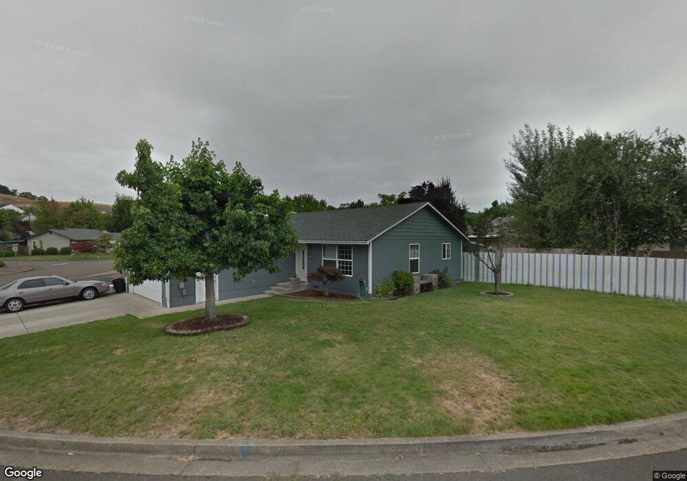
136 Corona Loop Rd Roseburg, OR 97471
Green NeighborhoodEstimated Value: $303,419 - $348,000
3
Beds
2
Baths
1,064
Sq Ft
$308/Sq Ft
Est. Value
About This Home
This home is located at 136 Corona Loop Rd, Roseburg, OR 97471 and is currently estimated at $327,605, approximately $307 per square foot. 136 Corona Loop Rd is a home located in Douglas County with nearby schools including Sunnyslope Elementary School, John C. Fremont Middle School, and Roseburg High School.
Ownership History
Date
Name
Owned For
Owner Type
Purchase Details
Closed on
Nov 29, 2007
Sold by
Rogers Derek W and Rogers Jodi A
Bought by
Valenzuela Benjamin
Current Estimated Value
Home Financials for this Owner
Home Financials are based on the most recent Mortgage that was taken out on this home.
Original Mortgage
$193,063
Outstanding Balance
$122,579
Interest Rate
6.36%
Mortgage Type
VA
Estimated Equity
$205,026
Create a Home Valuation Report for This Property
The Home Valuation Report is an in-depth analysis detailing your home's value as well as a comparison with similar homes in the area
Home Values in the Area
Average Home Value in this Area
Purchase History
| Date | Buyer | Sale Price | Title Company |
|---|---|---|---|
| Valenzuela Benjamin | $189,000 | First American Title Ins Co |
Source: Public Records
Mortgage History
| Date | Status | Borrower | Loan Amount |
|---|---|---|---|
| Open | Valenzuela Benjamin | $193,063 |
Source: Public Records
Tax History Compared to Growth
Tax History
| Year | Tax Paid | Tax Assessment Tax Assessment Total Assessment is a certain percentage of the fair market value that is determined by local assessors to be the total taxable value of land and additions on the property. | Land | Improvement |
|---|---|---|---|---|
| 2024 | $1,603 | $171,306 | -- | -- |
| 2023 | $1,556 | $166,317 | $0 | $0 |
| 2022 | $1,511 | $161,473 | $0 | $0 |
| 2021 | $1,467 | $156,770 | $0 | $0 |
| 2020 | $1,481 | $152,204 | $0 | $0 |
| 2019 | $1,454 | $147,771 | $0 | $0 |
| 2018 | $1,420 | $143,467 | $0 | $0 |
| 2017 | $1,378 | $139,289 | $0 | $0 |
| 2016 | $1,353 | $135,233 | $0 | $0 |
| 2015 | $1,093 | $107,805 | $0 | $0 |
| 2014 | $1,289 | $127,471 | $0 | $0 |
| 2013 | -- | $123,759 | $0 | $0 |
Source: Public Records
Map
Nearby Homes
- 248 Corona Loop Rd
- 225 Corona Loop Rd
- 150 Maywood Ct
- 157 Creekside Ct
- 129 Summerwood St
- 405 Corona Loop Rd
- 124 Aloha Ct
- 383 Little Valley Rd
- 1973 Castle Ave
- 1951 Austin Rd
- 275 Littlebrook Ln
- 231 Owyhee Ln
- 204 Rainbow Ridge Ave
- 2352 Castle Ave
- 120 Littlebrook Ln
- 129 S Park Ct
- 193 Owyhee Ln
- 122 Kristi Lee Ln
- 133 Jessica Lynn Ln
- 4033 Hanna St
- 105 Corona Loop Rd
- 112 Shaffer Ct
- 120 Shaffer Ct
- 145 Corona Loop Rd
- 608 Corona Loop Rd
- 155 Corona Loop Rd
- 135 Balboa Ave
- 137 Corona Loop Rd
- 119 Corona Loop Rd
- 129 Corona Loop Rd
- 169 Corona Loop Rd
- 130 Shaffer Ct
- 596 Corona Loop Rd
- 123 Shaffer Ct
- 607 Corona Loop Rd
- 189 Corona Loop Rd
- 113 Shaffer Ct
- 131 Little Valley Rd
- 113 Balboa Ave
- 162 Belmont Ave