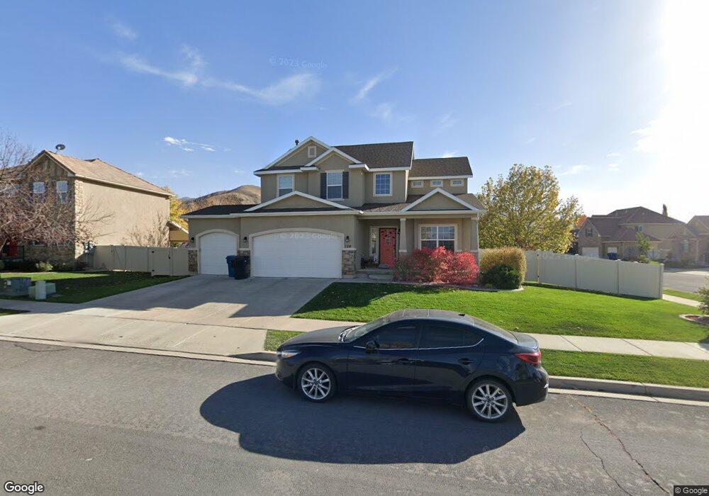
136 E 1170 S Payson, UT 84651
Estimated Value: $536,000 - $580,000
4
Beds
3
Baths
2,042
Sq Ft
$276/Sq Ft
Est. Value
About This Home
This home is located at 136 E 1170 S, Payson, UT 84651 and is currently estimated at $563,944, approximately $276 per square foot. 136 E 1170 S is a home located in Utah County with nearby schools including Park View Elementary, Payson High School, and Payson Junior High School.
Ownership History
Date
Name
Owned For
Owner Type
Purchase Details
Closed on
Sep 22, 2011
Sold by
Fratto Tracy C and Fratto Tim L
Bought by
Fratto Tim L and Fratto Tracy C
Current Estimated Value
Home Financials for this Owner
Home Financials are based on the most recent Mortgage that was taken out on this home.
Original Mortgage
$209,319
Outstanding Balance
$143,340
Interest Rate
4.26%
Mortgage Type
New Conventional
Estimated Equity
$420,604
Purchase Details
Closed on
Nov 19, 2009
Sold by
Homes By Harmony Inc
Bought by
Fratto Tim L and Fratto Tracy C
Home Financials for this Owner
Home Financials are based on the most recent Mortgage that was taken out on this home.
Original Mortgage
$212,826
Interest Rate
4.83%
Mortgage Type
New Conventional
Purchase Details
Closed on
Dec 23, 2008
Sold by
Richmond American Homes Of Utah Inc
Bought by
Salisbury Development Lc
Create a Home Valuation Report for This Property
The Home Valuation Report is an in-depth analysis detailing your home's value as well as a comparison with similar homes in the area
Home Values in the Area
Average Home Value in this Area
Purchase History
| Date | Buyer | Sale Price | Title Company |
|---|---|---|---|
| Fratto Tim L | -- | Provo Land Title Company | |
| Fratto Tim L | -- | Provo Land Title Company | |
| Salisbury Development Lc | -- | Equity Title Union Park |
Source: Public Records
Mortgage History
| Date | Status | Borrower | Loan Amount |
|---|---|---|---|
| Open | Fratto Tim L | $209,319 | |
| Closed | Fratto Tim L | $212,826 |
Source: Public Records
Tax History
| Year | Tax Paid | Tax Assessment Tax Assessment Total Assessment is a certain percentage of the fair market value that is determined by local assessors to be the total taxable value of land and additions on the property. | Land | Improvement |
|---|---|---|---|---|
| 2025 | $2,629 | $283,140 | -- | -- |
| 2024 | $2,629 | $267,575 | $0 | $0 |
| 2023 | $2,705 | $276,045 | $0 | $0 |
| 2022 | $2,713 | $272,305 | $0 | $0 |
| 2021 | $2,300 | $370,200 | $113,600 | $256,600 |
| 2020 | $2,182 | $343,600 | $103,300 | $240,300 |
| 2019 | $2,018 | $325,800 | $85,500 | $240,300 |
| 2018 | $1,919 | $298,600 | $74,800 | $223,800 |
| 2017 | $1,792 | $149,985 | $0 | $0 |
| 2016 | $1,716 | $142,725 | $0 | $0 |
| 2015 | $1,534 | $126,665 | $0 | $0 |
| 2014 | $1,401 | $116,545 | $0 | $0 |
Source: Public Records
Map
Nearby Homes
- 582 E 1250 S Unit 137
- 288 E 900 S
- 336 E 1330 S
- 876 Greenridge Ave
- 346 Jay Ln
- 252 E 670 S Unit 2
- 229 E 670 S Unit 7
- 88 W 700 S
- 420 E 600 S
- 1163 S 730 W
- 549 S Main St
- 609 W Saddlebrook Dr
- 245 W 1770 S
- 551 E 500 S
- 1836 S 100 E
- 1848 S 100 E Unit 3
- 1632 S 240 W Unit 47
- 1172 S 880 W
- 1631 S Highway 198
- 1835 S 410 W
Your Personal Tour Guide
Ask me questions while you tour the home.