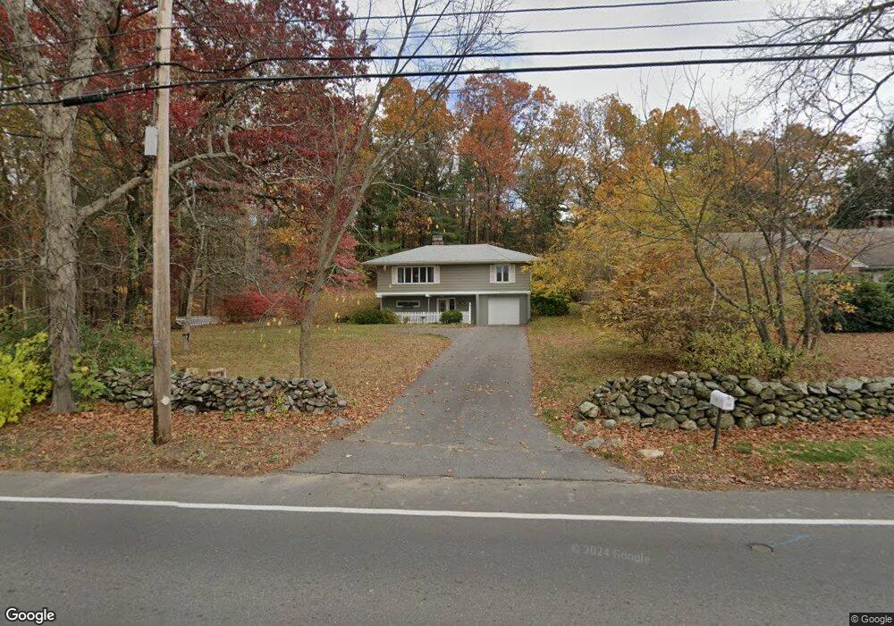
136 Main St Wilbraham, MA 01095
Estimated Value: $291,526 - $343,000
2
Beds
1
Bath
880
Sq Ft
$365/Sq Ft
Est. Value
About This Home
This home is located at 136 Main St, Wilbraham, MA 01095 and is currently estimated at $321,632, approximately $365 per square foot. 136 Main St is a home located in Hampden County with nearby schools including Minnechaug Regional High School and Wilbraham & Monson Academy.
Ownership History
Date
Name
Owned For
Owner Type
Purchase Details
Closed on
Jan 12, 2012
Sold by
Gaulin Linda J
Bought by
Monson Sb
Current Estimated Value
Purchase Details
Closed on
Nov 1, 2000
Sold by
Williston Alice L and Williston Eunice A
Bought by
Lovett Jayne E
Home Financials for this Owner
Home Financials are based on the most recent Mortgage that was taken out on this home.
Original Mortgage
$89,200
Interest Rate
7.83%
Mortgage Type
Purchase Money Mortgage
Purchase Details
Closed on
Dec 15, 1997
Sold by
Blodgett James K and Blodgett Linda L
Bought by
Gaulin Linda J
Home Financials for this Owner
Home Financials are based on the most recent Mortgage that was taken out on this home.
Original Mortgage
$55,650
Interest Rate
7.14%
Mortgage Type
Purchase Money Mortgage
Create a Home Valuation Report for This Property
The Home Valuation Report is an in-depth analysis detailing your home's value as well as a comparison with similar homes in the area
Home Values in the Area
Average Home Value in this Area
Purchase History
| Date | Buyer | Sale Price | Title Company |
|---|---|---|---|
| Monson Sb | $60,000 | -- | |
| Lovett Jayne E | $119,000 | -- | |
| Gaulin Linda J | $55,000 | -- |
Source: Public Records
Mortgage History
| Date | Status | Borrower | Loan Amount |
|---|---|---|---|
| Previous Owner | Gaulin Linda J | $40,000 | |
| Previous Owner | Gaulin Linda J | $89,200 | |
| Previous Owner | Gaulin Linda J | $55,650 | |
| Previous Owner | Gaulin Linda J | $50,000 |
Source: Public Records
Tax History
| Year | Tax Paid | Tax Assessment Tax Assessment Total Assessment is a certain percentage of the fair market value that is determined by local assessors to be the total taxable value of land and additions on the property. | Land | Improvement |
|---|---|---|---|---|
| 2025 | $4,722 | $264,100 | $76,800 | $187,300 |
| 2024 | $4,703 | $254,200 | $76,800 | $177,400 |
| 2023 | $4,506 | $258,500 | $76,800 | $181,700 |
| 2022 | $4,506 | $219,900 | $76,800 | $143,100 |
| 2021 | $4,319 | $188,100 | $82,600 | $105,500 |
| 2020 | $4,210 | $188,100 | $82,600 | $105,500 |
| 2019 | $3,939 | $180,700 | $82,600 | $98,100 |
| 2018 | $3,955 | $174,700 | $82,600 | $92,100 |
| 2017 | $3,843 | $174,700 | $82,600 | $92,100 |
| 2016 | $3,715 | $172,000 | $91,800 | $80,200 |
| 2015 | $3,591 | $172,000 | $91,800 | $80,200 |
Source: Public Records
Map
Nearby Homes
- 172 Main St
- 1 Aspen Dr
- 8 High Pine Cir
- 104 High Pine Cir
- 35 Lake Dr
- 4 Hillcrest Dr
- 16 Maple St
- 36 Maple St
- 20 Old Orchard Rd
- 474-480 Mountain Rd
- 46 Washington Rd
- 474 Mountain Rd
- 8 Patriot Ridge Ln
- 3076 Boston Rd
- 6 Hilltop Park
- 3 Mohawk St
- 6 Teak Terrace Unit 24
- 80 Elizabeth Dr
- 603 Glendale Rd
- 38 King Dr
Your Personal Tour Guide
Ask me questions while you tour the home.