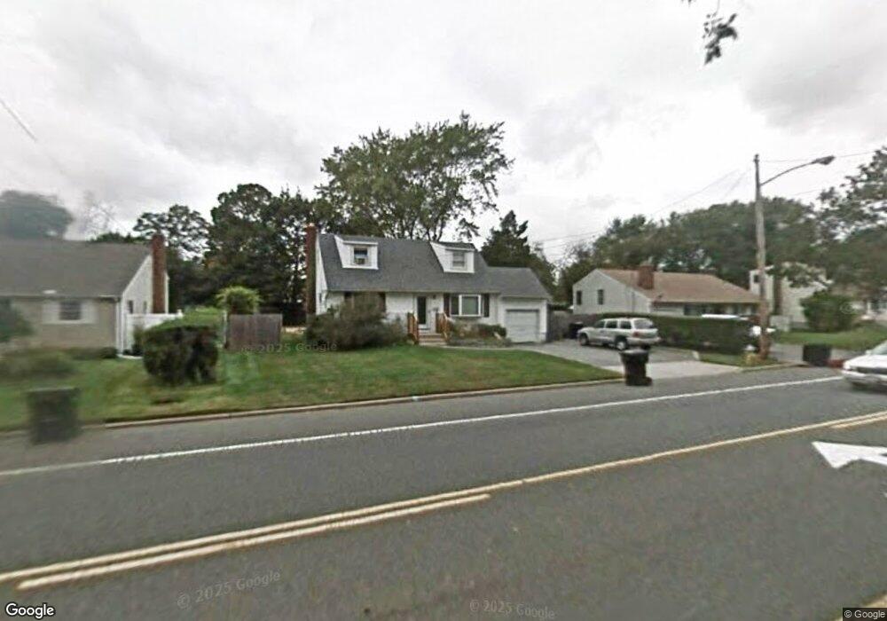
136 Udall Rd West Islip, NY 11795
Estimated Value: $477,947 - $689,000
--
Bed
--
Bath
--
Sq Ft
0.25
Acres
About This Home
This home is located at 136 Udall Rd, West Islip, NY 11795 and is currently estimated at $587,737. 136 Udall Rd is a home located in Suffolk County with nearby schools including Oquenock Elementary School, Udall Road Middle School, and West Islip Senior High School.
Ownership History
Date
Name
Owned For
Owner Type
Purchase Details
Closed on
Apr 18, 2024
Sold by
Gandolfo Charles
Bought by
Proiegt 2 King Llc
Current Estimated Value
Home Financials for this Owner
Home Financials are based on the most recent Mortgage that was taken out on this home.
Original Mortgage
$182,750
Interest Rate
6.87%
Mortgage Type
Commercial
Purchase Details
Closed on
Nov 13, 2003
Sold by
Nawrocki Bernard A
Bought by
Gandolfo Charles and Gandolfo Charles
Home Financials for this Owner
Home Financials are based on the most recent Mortgage that was taken out on this home.
Original Mortgage
$265,500
Interest Rate
5.9%
Mortgage Type
Purchase Money Mortgage
Purchase Details
Closed on
May 1, 1997
Sold by
Pilla Joseph and Pilla Iris
Bought by
Nawrocki Bernard A
Create a Home Valuation Report for This Property
The Home Valuation Report is an in-depth analysis detailing your home's value as well as a comparison with similar homes in the area
Home Values in the Area
Average Home Value in this Area
Purchase History
| Date | Buyer | Sale Price | Title Company |
|---|---|---|---|
| Proiegt 2 King Llc | $250,000 | None Available | |
| Proiegt 2 King Llc | $250,000 | None Available | |
| Gandolfo Charles | $295,000 | Commonwealth Land Title Insu | |
| Gandolfo Charles | $295,000 | Commonwealth Land Title Insu | |
| Nawrocki Bernard A | $112,000 | Commonwealth Land Title Ins | |
| Nawrocki Bernard A | $112,000 | Commonwealth Land Title Ins |
Source: Public Records
Mortgage History
| Date | Status | Borrower | Loan Amount |
|---|---|---|---|
| Previous Owner | Proiegt 2 King Llc | $182,750 | |
| Previous Owner | Proiegt 2 King Llc | $321,000 | |
| Previous Owner | Gandolfo Charles | $265,500 |
Source: Public Records
Tax History Compared to Growth
Tax History
| Year | Tax Paid | Tax Assessment Tax Assessment Total Assessment is a certain percentage of the fair market value that is determined by local assessors to be the total taxable value of land and additions on the property. | Land | Improvement |
|---|---|---|---|---|
| 2024 | $11,841 | $11,200 | $8,900 | $2,300 |
| 2023 | $11,841 | $40,000 | $8,900 | $31,100 |
| 2022 | $11,098 | $40,000 | $8,900 | $31,100 |
| 2021 | $11,098 | $40,000 | $8,900 | $31,100 |
| 2020 | $11,296 | $40,000 | $8,900 | $31,100 |
| 2019 | $11,296 | $0 | $0 | $0 |
| 2018 | -- | $40,000 | $8,900 | $31,100 |
| 2017 | $10,888 | $40,000 | $8,900 | $31,100 |
| 2016 | $10,912 | $40,000 | $8,900 | $31,100 |
| 2015 | -- | $40,000 | $8,900 | $31,100 |
| 2014 | -- | $40,000 | $8,900 | $31,100 |
Source: Public Records
Map
Nearby Homes
- 15 Anthony Dr
- 1280 Sunrise Hwy
- 47 Myson St
- 372 Hamilton Place
- 14 Gerek Ave
- 8 Gerek Ave
- 409 Capri Rd
- 166 W 2nd St
- 1345 Madison Ave
- 155 Reynolds Rd
- 118 W 6th St
- 2011 Orinoco Dr
- 1291 Minerva Ave
- 270 W 4th St
- 105 Graywood Ct
- 170 Wickfield Ln
- 134 Veronica Ln
- 16 Adams Place
- 43 Hitherdell Ln
- 801 Southside Ave