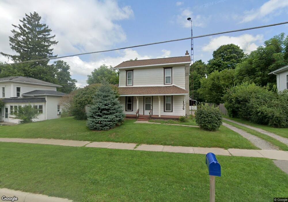
136 W Main St Springport, MI 49284
Estimated Value: $97,000 - $195,000
3
Beds
1
Bath
1,210
Sq Ft
$106/Sq Ft
Est. Value
About This Home
This home is located at 136 W Main St, Springport, MI 49284 and is currently estimated at $128,161, approximately $105 per square foot. 136 W Main St is a home located in Jackson County with nearby schools including Springport Elementary School, Springport Middle School, and Springport High School.
Ownership History
Date
Name
Owned For
Owner Type
Purchase Details
Closed on
Jun 27, 2018
Sold by
Barendregt Diana and The William J Barendregt And D
Bought by
Barendregt Diana
Current Estimated Value
Purchase Details
Closed on
Aug 6, 2009
Sold by
Ladd Gregg A
Bought by
Pierson Rick A and Pierson Victoria G
Home Financials for this Owner
Home Financials are based on the most recent Mortgage that was taken out on this home.
Original Mortgage
$24,000
Interest Rate
6.37%
Mortgage Type
Purchase Money Mortgage
Purchase Details
Closed on
Nov 10, 2005
Sold by
Mcclain Ronald F and Mcclain Phyllis M
Bought by
Mcclain Hardware Llc
Create a Home Valuation Report for This Property
The Home Valuation Report is an in-depth analysis detailing your home's value as well as a comparison with similar homes in the area
Purchase History
| Date | Buyer | Sale Price | Title Company |
|---|---|---|---|
| Barendregt Diana | -- | None Available | |
| Pearson Victoria Gail | -- | None Available | |
| Pierson Rick A | $30,000 | At | |
| Mcclain Hardware Llc | -- | -- |
Source: Public Records
Mortgage History
| Date | Status | Borrower | Loan Amount |
|---|---|---|---|
| Previous Owner | Pierson Rick A | $24,000 |
Source: Public Records
Tax History
| Year | Tax Paid | Tax Assessment Tax Assessment Total Assessment is a certain percentage of the fair market value that is determined by local assessors to be the total taxable value of land and additions on the property. | Land | Improvement |
|---|---|---|---|---|
| 2025 | $1,028 | $41,300 | $0 | $0 |
| 2024 | $6 | $44,700 | $0 | $0 |
| 2023 | $614 | $38,400 | $0 | $0 |
| 2022 | $1,221 | $32,300 | $0 | $0 |
| 2021 | $924 | $30,700 | $0 | $0 |
| 2020 | $277 | $29,900 | $0 | $0 |
| 2019 | $1,288 | $26,100 | $0 | $0 |
| 2018 | $869 | $23,700 | $0 | $0 |
| 2017 | $829 | $23,500 | $0 | $0 |
| 2016 | $261 | $23,200 | $23,200 | $0 |
| 2015 | -- | $26,000 | $26,000 | $0 |
| 2014 | -- | $31,600 | $0 | $0 |
| 2013 | -- | $31,600 | $31,600 | $0 |
Source: Public Records
Map
Nearby Homes
- 216 Bayport Cir Unit 10
- 252 Bay Port Cir Unit 19
- 598 E Main St
- 29510 S Dr N
- 16711 Stark Rd
- 10870 Eaton Rapids Rd
- 13025 Pope Church Rd
- 19822 27 1 2 Mile Rd
- 6600 Calhoun Rd
- 12261 Pope Church Rd
- 9733 Blue Heron
- 9761 Brown Rd
- 26854 Q-Drive N
- 12441 Town Rd
- 4371 Anderson Dr
- 5901 Monroe Rd
- 6950 Brown Rd
- 21133 26 Mile Rd
- 8840 Houston Rd
- V/L 26 1 2 Mile Rd
Your Personal Tour Guide
Ask me questions while you tour the home.