


1361 Peltier Dr Point Roberts, WA 98281
Estimated payment $661/month
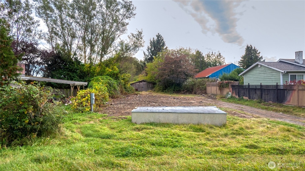
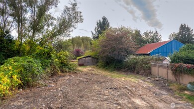
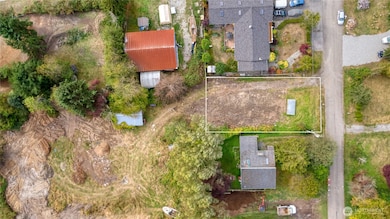
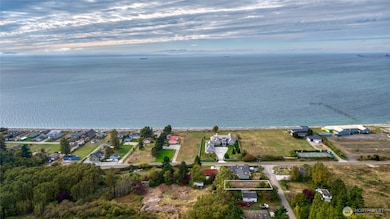
About This Lot
Located just steps from the Ocean, this Fully-serviced lot is the ideal property for you summer getaway or long term "retreat". Bring a trailer, mobile home or build your own house with the advantage of an existing septic system, connected water and power. Additionally, the lot behind can also be purchased to double your footprint and include an existing garage/shed. Call today for more details!
Source: Northwest Multiple Listing Service (NWMLS)
MLS#: 2444622
Property Details
Property Type
- Land
Est. Annual Taxes
- $320
Lot Details
- 6,273 Sq Ft Lot
Utilities
- Water Not Available
- Well Required
- Septic Design Installed
- Sewer Not Available
Community Details
- No Home Owners Association
- Point Roberts Subdivision
Listing and Financial Details
- Assessor Parcel Number 405304504048000
Map
Home Values in the Area
Average Home Value in this Area
Tax History
| Year | Tax Paid | Tax Assessment Tax Assessment Total Assessment is a certain percentage of the fair market value that is determined by local assessors to be the total taxable value of land and additions on the property. | Land | Improvement |
|---|---|---|---|---|
| 2024 | $1,057 | $119,680 | $119,680 | -- |
| 2023 | $1,057 | $108,800 | $108,800 | $0 |
| 2022 | $752 | $85,000 | $85,000 | $0 |
| 2021 | $760 | $57,665 | $57,665 | $0 |
| 2020 | $749 | $54,400 | $54,400 | $0 |
| 2019 | $530 | $50,750 | $50,750 | $0 |
| 2018 | $579 | $49,000 | $49,000 | $0 |
| 2017 | $505 | $49,000 | $49,000 | $0 |
| 2016 | $504 | $50,000 | $50,000 | $0 |
| 2015 | $522 | $48,565 | $48,565 | $0 |
| 2014 | -- | $49,445 | $49,445 | $0 |
| 2013 | -- | $55,000 | $55,000 | $0 |
Property History
| Date | Event | Price | List to Sale | Price per Sq Ft |
|---|---|---|---|---|
| 10/15/2025 10/15/25 | For Sale | $120,000 | -- | -- |
Purchase History
| Date | Type | Sale Price | Title Company |
|---|---|---|---|
| Quit Claim Deed | -- | None Available | |
| Warranty Deed | $180,280 | Chicago Title Insurance | |
| Warranty Deed | -- | Whatcom Land Title |
Mortgage History
| Date | Status | Loan Amount | Loan Type |
|---|---|---|---|
| Previous Owner | $144,000 | Purchase Money Mortgage |
Source: Northwest Multiple Listing Service (NWMLS)
MLS Number: 2444622
APN: 405304-504048-0000
Disclaimer: Certain information contained herein is derived from information provided by parties other than Homes.com. All information provided is deemed reliable, but is not guaranteed to be accurate and should be independently verified.
![]() All data is obtained from various sources and may not have been verified by broker or MLS GRID. Supplied Open House Information is subject to change without notice. All information should be independently reviewed and verified for accuracy. Properties may or may not be listed by the office/agent presenting the information. Listing information is provided by the Northwest Multiple Listing Service (NWMLS). Property information is based on available data that may include MLS information, county records, and other sources. Listings marked with the 3 tree icon and provided by NWMLS. All properties are subject to prior sale or withdrawal. IDX information is provided exclusively for consumers’ personal noncommercial use, that it may not be used for any purpose other than to identify prospective properties consumers may be interested in purchasing, that the data is deemed reliable but is not guaranteed by MLS GRID. ©2025 NWMLS.
All data is obtained from various sources and may not have been verified by broker or MLS GRID. Supplied Open House Information is subject to change without notice. All information should be independently reviewed and verified for accuracy. Properties may or may not be listed by the office/agent presenting the information. Listing information is provided by the Northwest Multiple Listing Service (NWMLS). Property information is based on available data that may include MLS information, county records, and other sources. Listings marked with the 3 tree icon and provided by NWMLS. All properties are subject to prior sale or withdrawal. IDX information is provided exclusively for consumers’ personal noncommercial use, that it may not be used for any purpose other than to identify prospective properties consumers may be interested in purchasing, that the data is deemed reliable but is not guaranteed by MLS GRID. ©2025 NWMLS.
Based on information submitted to the MLS GRID
- 581 Marine Dr
- 1379 Gulf Rd
- 631 Freemans Ln
- 0 Peltier Dr Unit NWM2406572
- 0 Peltier Dr Unit NWM2444621
- 1438 Gulf Rd
- Lot #8 Marine Dr
- 585 Marine Dr
- 421 W Bluff Rd
- 1561 Ocean View Ln
- 381 W Bluff Rd
- 1542 Columbia Vista Dr
- 230 Iris Blvd
- 11 Lot Rex St
- 329 Gulf View Crescent
- 0 Edwards Dr Unit Lot 2 11256474
- 1477 Edwards Dr
- 1453 Edwards Dr
- 1587 Harbor Seal Dr
- 1561 Edwards Dr
