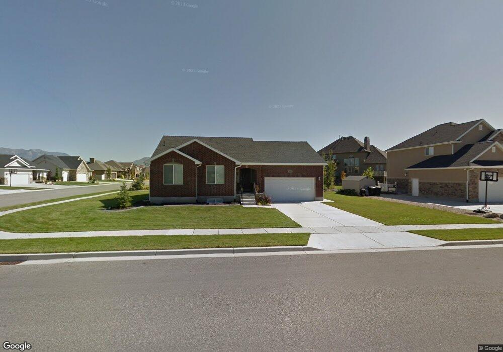
1361 W 1875 S Syracuse, UT 84075
Estimated Value: $504,000 - $539,000
3
Beds
2
Baths
1,360
Sq Ft
$383/Sq Ft
Est. Value
About This Home
This home is located at 1361 W 1875 S, Syracuse, UT 84075 and is currently estimated at $521,359, approximately $383 per square foot. 1361 W 1875 S is a home located in Davis County with nearby schools including Cook School, Legacy Junior High School, and Clearfield High School.
Ownership History
Date
Name
Owned For
Owner Type
Purchase Details
Closed on
Oct 19, 2017
Sold by
Bowles Allen and Bowles Cheryl
Bought by
Allen Bowels and Bowles Trust
Current Estimated Value
Home Financials for this Owner
Home Financials are based on the most recent Mortgage that was taken out on this home.
Original Mortgage
$160,000
Outstanding Balance
$133,681
Interest Rate
3.83%
Mortgage Type
New Conventional
Estimated Equity
$387,678
Purchase Details
Closed on
Sep 1, 2005
Sold by
Boyer Antelope Run Lc
Bought by
Hardy Karin
Home Financials for this Owner
Home Financials are based on the most recent Mortgage that was taken out on this home.
Original Mortgage
$187,000
Interest Rate
5.64%
Mortgage Type
Fannie Mae Freddie Mac
Create a Home Valuation Report for This Property
The Home Valuation Report is an in-depth analysis detailing your home's value as well as a comparison with similar homes in the area
Home Values in the Area
Average Home Value in this Area
Purchase History
| Date | Buyer | Sale Price | Title Company |
|---|---|---|---|
| Allen Bowels | -- | Integrated Title | |
| Bowles Allen | -- | Vanguard Title | |
| Hardy Karin | -- | Bonneville Title Company |
Source: Public Records
Mortgage History
| Date | Status | Borrower | Loan Amount |
|---|---|---|---|
| Open | Bowles Allen | $160,000 | |
| Closed | Allen Bowels | $160,000 | |
| Previous Owner | Hardy Karin | $187,000 |
Source: Public Records
Tax History Compared to Growth
Tax History
| Year | Tax Paid | Tax Assessment Tax Assessment Total Assessment is a certain percentage of the fair market value that is determined by local assessors to be the total taxable value of land and additions on the property. | Land | Improvement |
|---|---|---|---|---|
| 2025 | $2,753 | $265,650 | $116,172 | $149,478 |
| 2024 | $2,599 | $252,450 | $93,716 | $158,734 |
| 2023 | $2,514 | $445,000 | $130,715 | $314,285 |
| 2022 | $2,681 | $260,150 | $75,567 | $184,583 |
| 2021 | $2,330 | $350,000 | $111,404 | $238,596 |
| 2020 | $2,070 | $301,000 | $98,229 | $202,771 |
| 2019 | $2,020 | $290,000 | $94,569 | $195,431 |
| 2018 | $1,874 | $267,000 | $92,108 | $174,892 |
| 2016 | $1,623 | $121,275 | $35,406 | $85,869 |
| 2015 | $1,680 | $119,570 | $35,406 | $84,164 |
| 2014 | $1,555 | $112,803 | $35,406 | $77,397 |
| 2013 | -- | $101,449 | $38,775 | $62,674 |
Source: Public Records
Map
Nearby Homes
- 1876 S 1230 W
- 1153 W 1875 S
- 1154 W 1700 S
- 1142 W 2050 S
- 1148 W 2050 S
- 1079 W 2050 S
- 992 W 1910 S
- 1481 S Melanie Ln
- 1622 S 1000 W
- 929 W 1920 S Unit A
- 2082 S 1730 W
- 1306 W 2325 S
- 1286 W 2325 S
- 1276 W 2325 S
- 1384 S Melanie Ln
- 2355 S 1230 W
- 1196 W 2325 S
- 1137 W 2275 S
- 891 W 1920 S Unit C
- 891 W 1840 S Unit A