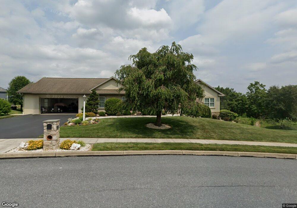
1364 Pheasant Run Rd Middletown, PA 17057
Estimated Value: $451,000 - $557,000
4
Beds
3
Baths
2,280
Sq Ft
$219/Sq Ft
Est. Value
About This Home
This home is located at 1364 Pheasant Run Rd, Middletown, PA 17057 and is currently estimated at $498,421, approximately $218 per square foot. 1364 Pheasant Run Rd is a home located in Dauphin County with nearby schools including Middletown Area Middle School, Middletown Area High School, and The Samuel School.
Ownership History
Date
Name
Owned For
Owner Type
Purchase Details
Closed on
Mar 29, 2018
Sold by
Dechant William A and Dechant Cheryl M
Bought by
The Dechant Family Protector Trust and Dechant William A
Current Estimated Value
Purchase Details
Closed on
Apr 25, 2008
Sold by
Ensminger Builders Inc
Bought by
Dechant William A
Home Financials for this Owner
Home Financials are based on the most recent Mortgage that was taken out on this home.
Original Mortgage
$85,000
Outstanding Balance
$54,780
Interest Rate
6.22%
Mortgage Type
New Conventional
Estimated Equity
$443,641
Create a Home Valuation Report for This Property
The Home Valuation Report is an in-depth analysis detailing your home's value as well as a comparison with similar homes in the area
Home Values in the Area
Average Home Value in this Area
Purchase History
| Date | Buyer | Sale Price | Title Company |
|---|---|---|---|
| The Dechant Family Protector Trust | -- | None Available | |
| Dechant William A | $365,000 | -- |
Source: Public Records
Mortgage History
| Date | Status | Borrower | Loan Amount |
|---|---|---|---|
| Open | Dechant William A | $85,000 |
Source: Public Records
Tax History
| Year | Tax Paid | Tax Assessment Tax Assessment Total Assessment is a certain percentage of the fair market value that is determined by local assessors to be the total taxable value of land and additions on the property. | Land | Improvement |
|---|---|---|---|---|
| 2025 | $7,057 | $186,200 | $31,700 | $154,500 |
| 2024 | $6,607 | $186,200 | $31,700 | $154,500 |
| 2023 | $6,460 | $186,200 | $31,700 | $154,500 |
| 2022 | $6,367 | $186,200 | $31,700 | $154,500 |
| 2021 | $6,367 | $186,200 | $31,700 | $154,500 |
| 2020 | $6,385 | $186,200 | $31,700 | $154,500 |
| 2019 | $6,285 | $186,200 | $31,700 | $154,500 |
| 2018 | $6,285 | $186,200 | $31,700 | $154,500 |
| 2017 | $6,267 | $186,200 | $31,700 | $154,500 |
| 2016 | $0 | $186,200 | $31,700 | $154,500 |
| 2015 | -- | $186,200 | $31,700 | $154,500 |
| 2014 | -- | $273,800 | $31,700 | $242,100 |
Source: Public Records
Map
Nearby Homes
- 481 Longview Dr
- 905 Ebenezer Rd
- 859 Anthony Dr
- 126 East Ln
- 0 Anthony Dr
- 6136 Friar Rd
- 551 Strites Rd
- 7736 Chambers Hill Rd
- 771 Hoffman Dr
- 6470 Colchester Ave
- 6481 Chambers Hill Rd
- 857 Gregs Dr
- 861 Gregs Dr
- 8050 Chambers Hill Rd
- 8157 Spruce Dr
- 721 S 82nd St Unit L111
- 119 Andrew Dr
- 2400 Fulling Mill Rd
- 1 Rovak Dr
- 1290 Woodridge Dr
- 1372 Pheasant Run Rd
- 1356 Pheasant Run Rd
- 1365 Pheasant Run Rd
- 1380 Pheasant Run Rd
- 1326 Butter Churn Rd Unit L320
- 1375 Pheasant Run Rd
- 1316 Butter Churn Rd Unit L319
- 1336 Butter Churn Rd Unit L322
- 1388 Pheasant Run Rd
- 1385 Pheasant Run Rd
- 1306 Butter Churn Rd Unit L318
- 1355 Pheasant Run Rd
- 1348 Pheasant Run Rd
- 1395 Pheasant Run Rd
- 2085 Powderhorn Rd
- 0 Butter Churn Rd Unit 1000784479
- 0 Butter Churn Rd Unit 1000784457
- 0 Butter Churn Rd Unit 1000784397
- 1325 Butter Churn Rd Unit L332
- 1315 Butter Churn Rd Unit L333
Your Personal Tour Guide
Ask me questions while you tour the home.