Estimated Value: $540,000 - $587,000
4
Beds
2
Baths
1,763
Sq Ft
$320/Sq Ft
Est. Value
About This Home
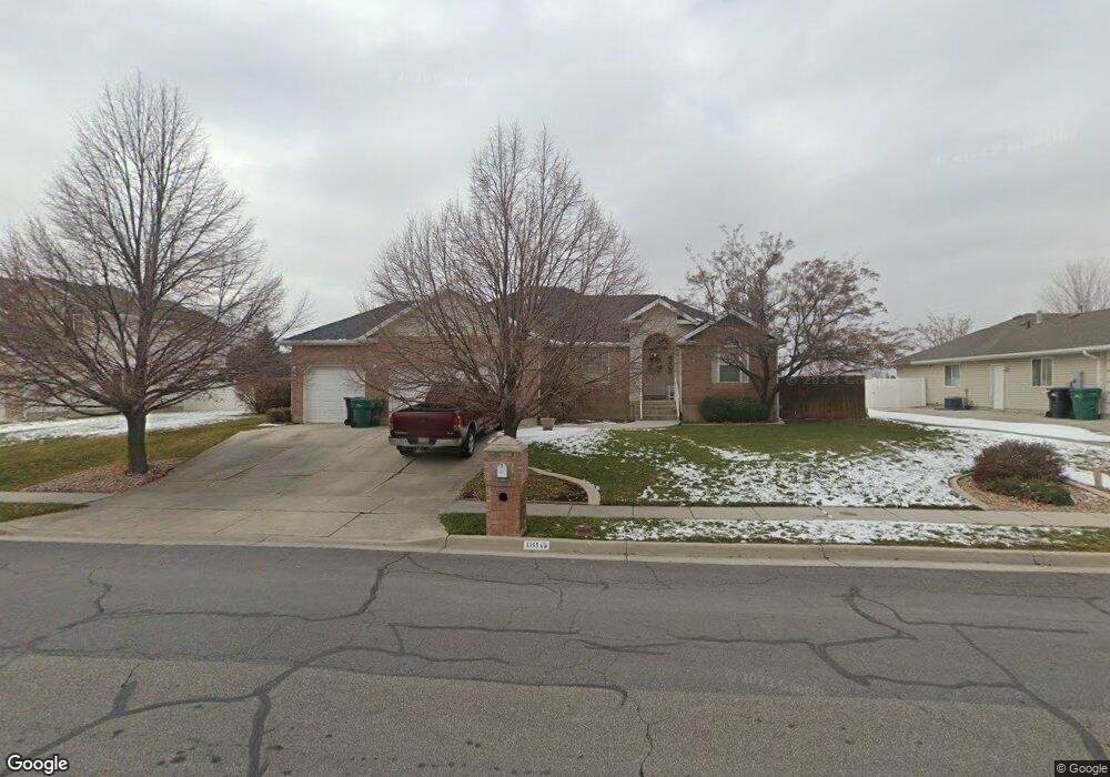
This home is located at 1365 N 100 E, Ogden, UT 84404 and is currently estimated at $563,366, approximately $319 per square foot. 1365 N 100 E is a home located in Weber County with nearby schools including Pioneer School, Orion Junior High School, and Fremont High School.
Ownership History
Date
Name
Owned For
Owner Type
Purchase Details
Closed on
Feb 25, 2025
Sold by
Colvin Roger L and Colvin Sonya H
Bought by
Roger And Sonya Colvin Family Trust and Colvin
Current Estimated Value
Purchase Details
Closed on
Jan 6, 1998
Sold by
Singleton Gary L
Bought by
Colvin Roger L and Colvin Sonya H
Home Financials for this Owner
Home Financials are based on the most recent Mortgage that was taken out on this home.
Original Mortgage
$112,000
Interest Rate
7.16%
Create a Home Valuation Report for This Property
The Home Valuation Report is an in-depth analysis detailing your home's value as well as a comparison with similar homes in the area
Home Values in the Area
Average Home Value in this Area
Purchase History
| Date | Buyer | Sale Price | Title Company |
|---|---|---|---|
| Roger And Sonya Colvin Family Trust | -- | None Listed On Document | |
| Colvin Roger L | -- | Mountain View Title |
Source: Public Records
Mortgage History
| Date | Status | Borrower | Loan Amount |
|---|---|---|---|
| Previous Owner | Colvin Roger L | $112,000 |
Source: Public Records
Tax History
| Year | Tax Paid | Tax Assessment Tax Assessment Total Assessment is a certain percentage of the fair market value that is determined by local assessors to be the total taxable value of land and additions on the property. | Land | Improvement |
|---|---|---|---|---|
| 2025 | $4,211 | $619,644 | $142,255 | $477,389 |
| 2024 | $4,129 | $334,399 | $78,240 | $256,159 |
| 2023 | $3,598 | $292,050 | $78,240 | $213,810 |
| 2022 | $3,691 | $307,450 | $67,182 | $240,268 |
| 2021 | $2,707 | $408,000 | $76,889 | $331,111 |
| 2020 | $2,557 | $356,000 | $61,285 | $294,715 |
| 2019 | $2,490 | $328,000 | $51,249 | $276,751 |
| 2018 | $2,494 | $315,000 | $51,249 | $263,751 |
| 2017 | $2,229 | $263,000 | $51,249 | $211,751 |
| 2016 | $2,263 | $145,279 | $28,491 | $116,788 |
| 2015 | $2,054 | $129,667 | $25,729 | $103,938 |
| 2014 | $1,994 | $123,294 | $25,729 | $97,565 |
Source: Public Records
Map
Nearby Homes
- 1307 N 225 W
- 116 E 1150 N
- 1212 N Virginia Ave
- 302 E 1275 N Unit 109
- 293 E 1500 North St
- 1268 N 300 E Unit 177
- 1262 N 300 E Unit 178
- 1256 N 300 E Unit 179
- 318 E 1275 N Unit 115
- 1252 N 300 E Unit 180
- 322 E 1275 N Unit 117
- 1263 N 325 E Unit 173
- 324 E 1275 N Unit 118
- 328 E 1275 N Unit 120
- 330 E 1275 N Unit 121
- 1273 N 375 E Unit 153
- 2440 U S Highway 89
- 315 E 1650 N Unit 124
- 315 E 1650 N Unit 125
- 315 E 1650 N Unit 127
Your Personal Tour Guide
Ask me questions while you tour the home.