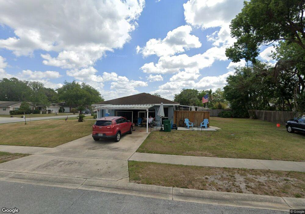
137 Dellwood Dr Longwood, FL 32750
Estimated Value: $352,592 - $441,000
3
Beds
2
Baths
1,560
Sq Ft
$254/Sq Ft
Est. Value
About This Home
This home is located at 137 Dellwood Dr, Longwood, FL 32750 and is currently estimated at $396,898, approximately $254 per square foot. 137 Dellwood Dr is a home located in Seminole County with nearby schools including Lyman High School, Woodlands Elementary School, and Rock Lake Middle School.
Ownership History
Date
Name
Owned For
Owner Type
Purchase Details
Closed on
Oct 13, 2015
Sold by
Epps Beverly L
Bought by
Lewis Linda
Current Estimated Value
Home Financials for this Owner
Home Financials are based on the most recent Mortgage that was taken out on this home.
Original Mortgage
$292,500
Outstanding Balance
$226,883
Interest Rate
3.47%
Mortgage Type
Reverse Mortgage Home Equity Conversion Mortgage
Estimated Equity
$170,015
Purchase Details
Closed on
May 1, 1980
Bought by
Lewis Linda
Purchase Details
Closed on
Dec 1, 1978
Bought by
Lewis Linda
Create a Home Valuation Report for This Property
The Home Valuation Report is an in-depth analysis detailing your home's value as well as a comparison with similar homes in the area
Home Values in the Area
Average Home Value in this Area
Purchase History
| Date | Buyer | Sale Price | Title Company |
|---|---|---|---|
| Lewis Linda | $195,000 | First Intl Title Inc | |
| Lewis Linda | $73,000 | -- | |
| Lewis Linda | $57,500 | -- |
Source: Public Records
Mortgage History
| Date | Status | Borrower | Loan Amount |
|---|---|---|---|
| Open | Lewis Linda | $292,500 |
Source: Public Records
Tax History Compared to Growth
Tax History
| Year | Tax Paid | Tax Assessment Tax Assessment Total Assessment is a certain percentage of the fair market value that is determined by local assessors to be the total taxable value of land and additions on the property. | Land | Improvement |
|---|---|---|---|---|
| 2024 | $1,713 | $187,647 | -- | -- |
| 2023 | $1,642 | $182,182 | $0 | $0 |
| 2021 | $1,617 | $171,724 | $0 | $0 |
| 2020 | $1,595 | $169,353 | $0 | $0 |
| 2019 | $1,562 | $165,545 | $0 | $0 |
| 2018 | $1,811 | $162,458 | $0 | $0 |
| 2017 | $1,790 | $159,117 | $0 | $0 |
| 2016 | $1,865 | $156,935 | $0 | $0 |
| 2015 | $1,311 | $110,695 | $0 | $0 |
| 2014 | $1,300 | $109,816 | $0 | $0 |
Source: Public Records
Map
Nearby Homes
- 119 Glendale Dr
- 1200 Waverly Way
- 101 Ardsdale Ct
- 107 Palm Springs Dr
- 225 Slade Dr
- 212 Sheridan Ave
- TBD Rock Lake Rd
- 114 Rock Lake Rd
- 104 Rock Lake Rd
- 1501 Pearl St
- 204 Adair Ave
- 334 Maple Dr
- 342 Maple Dr
- 111 Tarrytown Trail
- 113 Tarrytown Trail
- 120 Lake Oaks Blvd
- 1143 Autumn Brook Cir
- 204 Brom Bones Ln
- 1415 W Marvin St
- 635 Cambridge Ct
- 135 Dellwood Dr
- 136 Glendale Dr
- 105 Pine Crest
- 103 Pine Crescent
- 134 Glendale Dr
- 136 Dellwood Dr
- 133 Dellwood Dr
- 101 Pine Crest
- 134 Dellwood Dr
- 138 Dellwood Dr
- 132 Glendale Dr
- 132 Dellwood Dr
- 129 Dellwood Dr
- 107 Pine Crest
- 102 Tollgate Trail
- 123 Sheridan Ct
- 130 Glendale Dr
- 121 Sheridan Ct
- 130 Dellwood Dr
- 104 Tollgate Trail