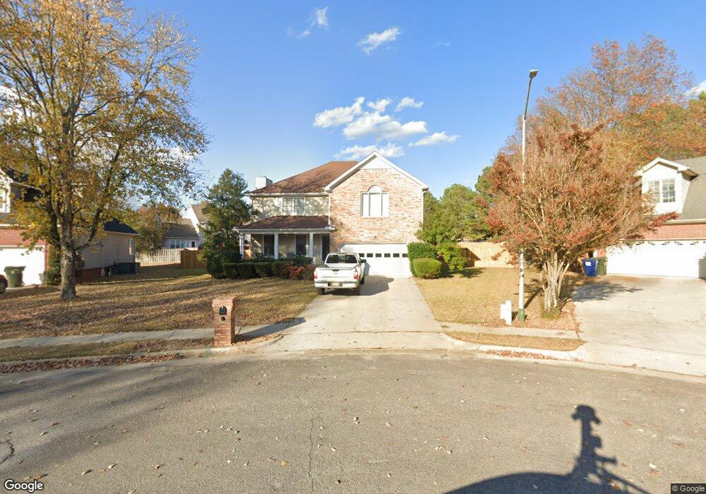
137 Leabrook Cir Madison, AL 35758
Estimated Value: $420,345 - $457,000
Studio
1
Bath
1,080
Sq Ft
$401/Sq Ft
Est. Value
About This Home
This home is located at 137 Leabrook Cir, Madison, AL 35758 and is currently estimated at $433,586, approximately $401 per square foot. 137 Leabrook Cir is a home with nearby schools including Rainbow Elementary School, Discovery Middle School, and Bob Jones High School.
Ownership History
Date
Name
Owned For
Owner Type
Purchase Details
Closed on
Aug 12, 2005
Sold by
Cotton Francis Paul and Cotton Robin
Bought by
Blue Gregory L and Blue Michelle
Current Estimated Value
Home Financials for this Owner
Home Financials are based on the most recent Mortgage that was taken out on this home.
Original Mortgage
$188,977
Outstanding Balance
$96,873
Interest Rate
5.48%
Mortgage Type
VA
Estimated Equity
$336,713
Create a Home Valuation Report for This Property
The Home Valuation Report is an in-depth analysis detailing your home's value as well as a comparison with similar homes in the area
Home Values in the Area
Average Home Value in this Area
Purchase History
| Date | Buyer | Sale Price | Title Company |
|---|---|---|---|
| Blue Gregory L | -- | None Available |
Source: Public Records
Mortgage History
| Date | Status | Borrower | Loan Amount |
|---|---|---|---|
| Open | Blue Gregory L | $188,977 |
Source: Public Records
Tax History
| Year | Tax Paid | Tax Assessment Tax Assessment Total Assessment is a certain percentage of the fair market value that is determined by local assessors to be the total taxable value of land and additions on the property. | Land | Improvement |
|---|---|---|---|---|
| 2025 | $2,892 | $42,160 | $7,500 | $34,660 |
| 2024 | $2,892 | $41,340 | $7,500 | $33,840 |
| 2023 | $2,835 | $39,980 | $7,500 | $32,480 |
| 2022 | $2,300 | $33,640 | $5,400 | $28,240 |
| 2021 | $1,857 | $27,260 | $2,040 | $25,220 |
| 2020 | $1,758 | $25,820 | $2,030 | $23,790 |
| 2019 | $1,379 | $24,620 | $2,030 | $22,590 |
| 2018 | $1,299 | $23,260 | $0 | $0 |
| 2017 | $1,288 | $23,060 | $0 | $0 |
| 2016 | $1,288 | $23,060 | $0 | $0 |
| 2015 | $1,288 | $23,060 | $0 | $0 |
| 2014 | $1,261 | $22,760 | $0 | $0 |
Source: Public Records
Map
Nearby Homes
- 104 Brookdel Dr
- 1231 Hughes Rd
- 203 Silverado Dr
- 108 Whitehall
- 131 Silver Lake Cir
- 303 Bradford Farms Dr
- 3.44 acres Highway 72
- 4.9 Acres Highway 72
- 104 Patra Dr
- 102 Wildweed Ct
- 144 Arabian Dr
- 29111 Highway 72
- 141 Antique Rose Dr
- 325 Bradford Farms Dr
- 501 Gooch Ln
- 150 Antique Rose Dr
- 111 Lonesome Ct
- 1 Thomas Dr
- 6001 Wall Triana Hwy
- 5190 Wall Triana Hwy
- 135 Leabrook Cir
- 139 Leabrook Cir
- 104 Ramble Cir
- 106 Ramble Cir
- 138 Leabrook Cir
- 133 Leabrook Cir
- 202 Pebblebrook Dr
- 202 Pebblebrook Dr
- 136 Leabrook Cir
- 134 Leabrook Cir
- 108 Ramble Cir
- 132 Leabrook Cir
- 12 Gatehouse Ct
- 130 Lea Brook Cir
- 130 Leabrook Cir
- 127 Leabrook Cir
- 204 Pebblebrook Dr
- 10 Gatehouse Ct
- 204 Pebble Brook Dr
- 14 Gatehouse Ct
Your Personal Tour Guide
Ask me questions while you tour the home.