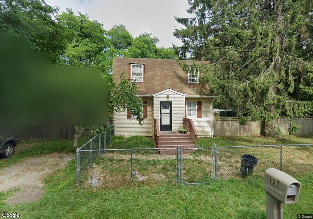
137 Locust Dr Mastic Beach, NY 11951
Estimated Value: $426,000 - $509,000
--
Bed
--
Bath
--
Sq Ft
10,019
Sq Ft Lot
About This Home
This home is located at 137 Locust Dr, Mastic Beach, NY 11951 and is currently estimated at $456,639. 137 Locust Dr is a home located in Suffolk County with nearby schools including Tangier Smith Elementary School, William Paca Middle School, and William Floyd High School.
Ownership History
Date
Name
Owned For
Owner Type
Purchase Details
Closed on
Mar 22, 2010
Sold by
Abbate Thomas A and Curry Paul
Bought by
Island Equity Group Inc
Current Estimated Value
Purchase Details
Closed on
Feb 17, 2006
Purchase Details
Closed on
Sep 26, 2003
Sold by
Debenedetto Thomas J and Debenedetto Barbara A
Bought by
Curry Paul
Home Financials for this Owner
Home Financials are based on the most recent Mortgage that was taken out on this home.
Original Mortgage
$188,000
Interest Rate
7.25%
Mortgage Type
Purchase Money Mortgage
Purchase Details
Closed on
Oct 11, 2001
Sold by
Hartsouth John and Hartsough Lori
Bought by
Debenedetto Thomas J and Debenedetto Barbara A
Home Financials for this Owner
Home Financials are based on the most recent Mortgage that was taken out on this home.
Original Mortgage
$134,950
Interest Rate
6.92%
Mortgage Type
FHA
Create a Home Valuation Report for This Property
The Home Valuation Report is an in-depth analysis detailing your home's value as well as a comparison with similar homes in the area
Home Values in the Area
Average Home Value in this Area
Purchase History
| Date | Buyer | Sale Price | Title Company |
|---|---|---|---|
| Island Equity Group Inc | $110,200 | -- | |
| -- | -- | -- | |
| Curry Paul | $235,000 | -- | |
| Debenedetto Thomas J | $143,000 | First American Title Ins Co |
Source: Public Records
Mortgage History
| Date | Status | Borrower | Loan Amount |
|---|---|---|---|
| Previous Owner | Curry Paul | $188,000 | |
| Previous Owner | Debenedetto Thomas J | $134,950 |
Source: Public Records
Tax History Compared to Growth
Tax History
| Year | Tax Paid | Tax Assessment Tax Assessment Total Assessment is a certain percentage of the fair market value that is determined by local assessors to be the total taxable value of land and additions on the property. | Land | Improvement |
|---|---|---|---|---|
| 2024 | $6,986 | $1,900 | $200 | $1,700 |
| 2023 | $6,986 | $1,900 | $200 | $1,700 |
| 2022 | $7,294 | $1,900 | $200 | $1,700 |
| 2021 | $7,294 | $1,900 | $200 | $1,700 |
| 2020 | $7,505 | $1,900 | $200 | $1,700 |
| 2019 | $7,505 | $0 | $0 | $0 |
| 2018 | -- | $1,900 | $200 | $1,700 |
Source: Public Records
Map
Nearby Homes
- 145 Monroe Dr
- New Construction Neighborhood Rd
- 0 Hemlock Dr
- 13 Hamilton Rd
- 10 Phyllis Dr
- 150 Beaver Dr
- 34 Hemlock Dr
- 178 Magnolia Dr
- 124 Cypress Dr
- 38 Barclay Rd
- 19 Doris Dr
- 242 Bayview Dr
- 8 Barclay Rd
- 8 King Rd W
- 115 Dahlia Dr
- 108 Mckinley Dr
- 159 Forest Rd E
- 29 Edwards Rd
- 249 Mckinley Dr
- 11 Edwards Rd