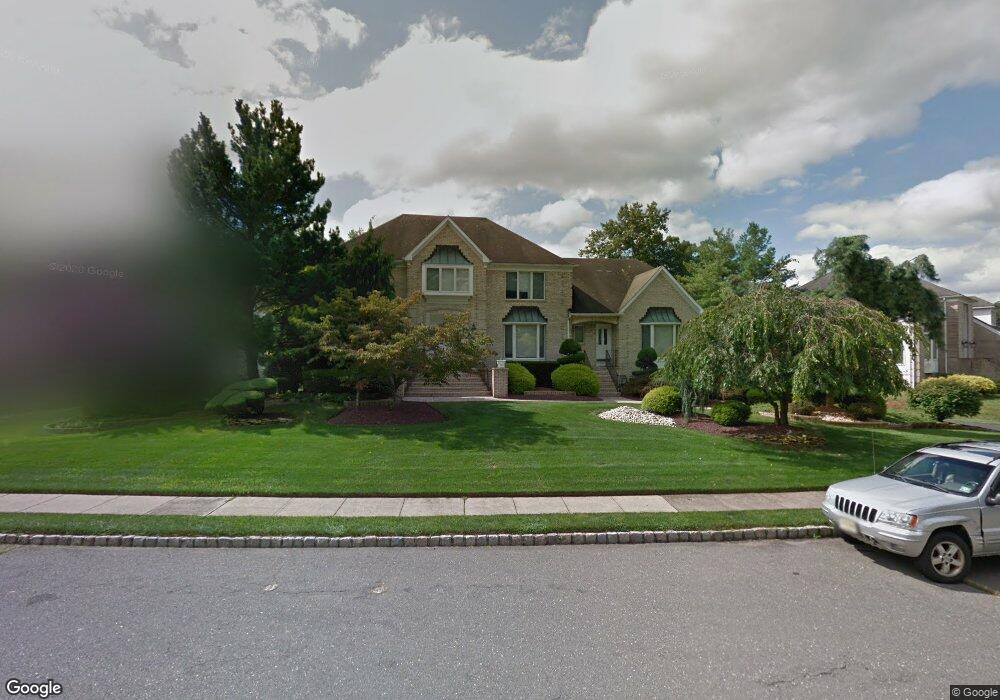
137 Micki Dr Morganville, NJ 07751
Estimated Value: $1,307,725 - $1,530,000
5
Beds
2
Baths
4,322
Sq Ft
$332/Sq Ft
Est. Value
About This Home
This home is located at 137 Micki Dr, Morganville, NJ 07751 and is currently estimated at $1,432,931, approximately $331 per square foot. 137 Micki Dr is a home located in Monmouth County with nearby schools including Asher Holmes Elementary School, Marlboro Middle School, and Marlboro High School.
Ownership History
Date
Name
Owned For
Owner Type
Purchase Details
Closed on
Feb 12, 2010
Sold by
Bauer Elliot
Bought by
Bauer Beth
Current Estimated Value
Purchase Details
Closed on
Jan 26, 1998
Sold by
Patterson Teresa Weber
Bought by
Bauer Beth
Home Financials for this Owner
Home Financials are based on the most recent Mortgage that was taken out on this home.
Original Mortgage
$220,000
Outstanding Balance
$38,773
Interest Rate
6.95%
Estimated Equity
$1,394,158
Purchase Details
Closed on
Oct 31, 1996
Sold by
Gerstel Linda
Bought by
Patterson Teresa Webe
Home Financials for this Owner
Home Financials are based on the most recent Mortgage that was taken out on this home.
Original Mortgage
$385,000
Interest Rate
7.99%
Create a Home Valuation Report for This Property
The Home Valuation Report is an in-depth analysis detailing your home's value as well as a comparison with similar homes in the area
Home Values in the Area
Average Home Value in this Area
Purchase History
| Date | Buyer | Sale Price | Title Company |
|---|---|---|---|
| Bauer Beth | -- | Coastal Title Agency Inc | |
| Bauer Beth | $520,000 | -- | |
| Patterson Teresa Webe | $427,500 | -- |
Source: Public Records
Mortgage History
| Date | Status | Borrower | Loan Amount |
|---|---|---|---|
| Open | Bauer Beth | $220,000 | |
| Previous Owner | Patterson Teresa Webe | $385,000 |
Source: Public Records
Tax History Compared to Growth
Tax History
| Year | Tax Paid | Tax Assessment Tax Assessment Total Assessment is a certain percentage of the fair market value that is determined by local assessors to be the total taxable value of land and additions on the property. | Land | Improvement |
|---|---|---|---|---|
| 2025 | $18,710 | $747,500 | $236,300 | $511,200 |
| 2024 | $17,933 | $747,500 | $236,300 | $511,200 |
| 2023 | $17,933 | $747,500 | $236,300 | $511,200 |
| 2022 | $17,499 | $747,500 | $236,300 | $511,200 |
| 2021 | $17,305 | $747,500 | $236,300 | $511,200 |
| 2020 | $17,305 | $747,500 | $236,300 | $511,200 |
| 2019 | $17,305 | $747,500 | $236,300 | $511,200 |
| 2018 | $17,013 | $747,500 | $236,300 | $511,200 |
| 2017 | $16,669 | $747,500 | $236,300 | $511,200 |
| 2016 | $16,609 | $747,500 | $236,300 | $511,200 |
| 2015 | $16,074 | $734,300 | $236,300 | $498,000 |
| 2014 | $15,780 | $713,700 | $236,300 | $477,400 |
Source: Public Records
Map
Nearby Homes
- 9 Bennett Ct
- 23 Eli Cir
- 7 Syngle Way
- 11 Woodview Dr
- 102 Parker Chase
- 308 Pilot St
- 102 Pilot St
- 218 Medford Ct Unit A
- 236 Medford Ct Unit G
- 11 Churchill Ct
- 21 Wickatunk Rd
- 34 Brookside Cir
- 230 Medford Ct Unit C
- 37 Willow Grove Way
- 205 Covered Bridge Blvd Unit K
- 28 Aspen Ave
- 126 Wyncrest Rd
- 25 Highland Dr
- 201 Forsythia Ln
- 351 Sunshine Ct Unit 231